James Topo Map Georgia
To zoom in, hover over the map of James
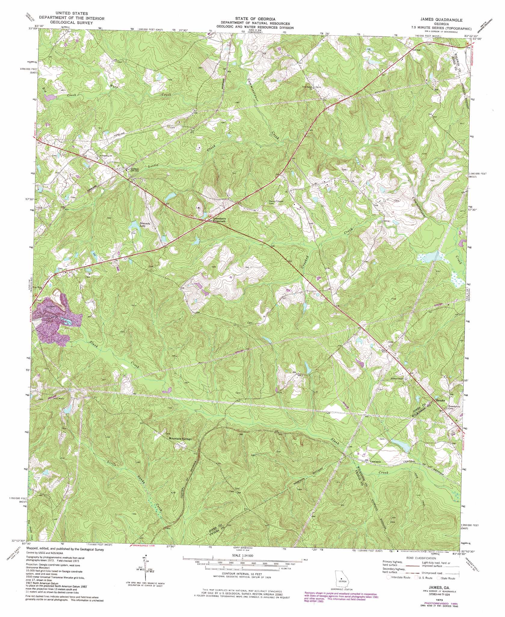
USGS Topo Quad 32083h4 - 1:24,000 scale
| Topo Map Name: | James |
| USGS Topo Quad ID: | 32083h4 |
| Print Size: | ca. 21 1/4" wide x 27" high |
| Southeast Coordinates: | 32.875° N latitude / 83.375° W longitude |
| Map Center Coordinates: | 32.9375° N latitude / 83.4375° W longitude |
| U.S. State: | GA |
| Filename: | o32083h4.jpg |
| Download Map JPG Image: | James topo map 1:24,000 scale |
| Map Type: | Topographic |
| Topo Series: | 7.5´ |
| Map Scale: | 1:24,000 |
| Source of Map Images: | United States Geological Survey (USGS) |
| Alternate Map Versions: |
James GA 1973, updated 1977 Download PDF Buy paper map James GA 1973, updated 1985 Download PDF Buy paper map James GA 2011 Download PDF Buy paper map James GA 2014 Download PDF Buy paper map |
1:24,000 Topo Quads surrounding James
Hillsboro |
Stanfordville |
Resseaus Crossroads |
Lake Sinclair West |
Lake Sinclair East |
Dames Ferry |
Gray |
Haddock |
Browns Crossing |
Milledgeville |
Macon Nw |
Macon Ne |
James |
Gordon |
Napier Pond |
Macon West |
Macon East |
Dry Branch |
Massey Hill |
Irwinton |
Warner Robins Nw |
Warner Robins Ne |
Marion |
Jeffersonville |
Stuckey Boone Lake |
> Back to 32083e1 at 1:100,000 scale
> Back to 32082a1 at 1:250,000 scale
> Back to U.S. Topo Maps home
James topo map: Gazetteer
James: Dams
Griffin Lake Dam elevation 173m 567′Jones Lake Dam elevation 150m 492′
Oetter Lake Dam elevation 117m 383′
Ray Lake Dam elevation 166m 544′
Slocumbs Lake Dam elevation 153m 501′
James: Populated Places
Brooks elevation 159m 521′Greenberry Crossroads elevation 174m 570′
James elevation 150m 492′
Lewiston elevation 117m 383′
Mountain Springs elevation 164m 538′
James: Reservoirs
Griffin Lake elevation 173m 567′Jones Lake elevation 150m 492′
Oetter Lake elevation 117m 383′
Otter Lake elevation 116m 380′
Ray Lake elevation 166m 544′
Slocumbs Lake elevation 153m 501′
James: Streams
Big Creek elevation 132m 433′Crooked Creek elevation 103m 337′
Little Creek elevation 124m 406′
Wolf Creek elevation 124m 406′
James digital topo map on disk
Buy this James topo map showing relief, roads, GPS coordinates and other geographical features, as a high-resolution digital map file on DVD:
South Carolina, Western North Carolina & Northeastern Georgia
Buy digital topo maps: South Carolina, Western North Carolina & Northeastern Georgia