Macon Ne Topo Map Georgia
To zoom in, hover over the map of Macon Ne
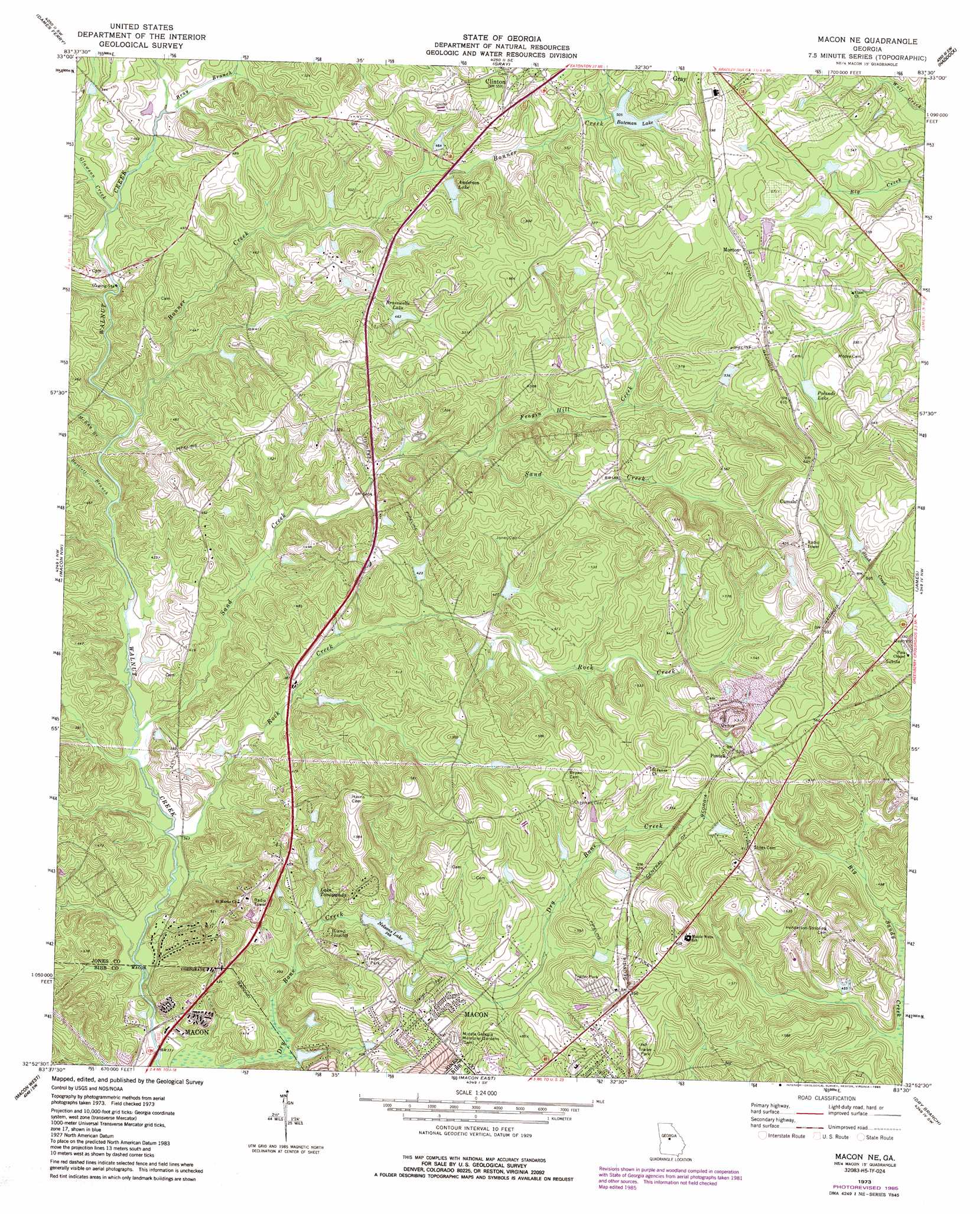
USGS Topo Quad 32083h5 - 1:24,000 scale
| Topo Map Name: | Macon Ne |
| USGS Topo Quad ID: | 32083h5 |
| Print Size: | ca. 21 1/4" wide x 27" high |
| Southeast Coordinates: | 32.875° N latitude / 83.5° W longitude |
| Map Center Coordinates: | 32.9375° N latitude / 83.5625° W longitude |
| U.S. State: | GA |
| Filename: | o32083h5.jpg |
| Download Map JPG Image: | Macon Ne topo map 1:24,000 scale |
| Map Type: | Topographic |
| Topo Series: | 7.5´ |
| Map Scale: | 1:24,000 |
| Source of Map Images: | United States Geological Survey (USGS) |
| Alternate Map Versions: |
Macon NE GA 1973, updated 1977 Download PDF Buy paper map Macon NE GA 1973, updated 1985 Download PDF Buy paper map Macon NE GA 2011 Download PDF Buy paper map Macon NE GA 2014 Download PDF Buy paper map |
1:24,000 Topo Quads surrounding Macon Ne
Berner |
Hillsboro |
Stanfordville |
Resseaus Crossroads |
Lake Sinclair West |
East Juliette |
Dames Ferry |
Gray |
Haddock |
Browns Crossing |
Bolingbroke |
Macon Nw |
Macon Ne |
James |
Gordon |
Lizella |
Macon West |
Macon East |
Dry Branch |
Massey Hill |
Byron |
Warner Robins Nw |
Warner Robins Ne |
Marion |
Jeffersonville |
> Back to 32083e1 at 1:100,000 scale
> Back to 32082a1 at 1:250,000 scale
> Back to U.S. Topo Maps home
Macon Ne topo map: Gazetteer
Macon Ne: Dams
Anderson Lake Dam elevation 142m 465′Bateman Lake Dam elevation 154m 505′
Brasswells Lake Dam elevation 140m 459′
Ethridge Dam elevation 163m 534′
Lake Tonowanda Dam elevation 109m 357′
Martin-Marietta Dam elevation 155m 508′
Nelsons Lake Dam elevation 112m 367′
Newberry Dam elevation 140m 459′
Polands Lake Dam elevation 172m 564′
Smith Dam elevation 122m 400′
Walker Dam elevation 157m 515′
Washburn Dam elevation 165m 541′
Macon Ne: Parks
Old Clinton Historic District elevation 168m 551′Macon Ne: Populated Places
Bowden Hills elevation 138m 452′Clinton elevation 167m 547′
Cumslo elevation 194m 636′
Jones Acres elevation 163m 534′
Joycliff Estates elevation 137m 449′
Kings View elevation 135m 442′
Morton elevation 171m 561′
Pitts elevation 161m 528′
Postell elevation 167m 547′
Macon Ne: Reservoirs
Anderson Lake elevation 142m 465′Bateman Lake elevation 154m 505′
Brasswells Lake elevation 140m 459′
Ethridge Lake elevation 163m 534′
Lake Tonawanda elevation 108m 354′
Lake Tonowanda elevation 109m 357′
Martin-Marietta Lake elevation 155m 508′
Nelsons Lake elevation 112m 367′
Newberry Lake elevation 140m 459′
Polands Lake elevation 172m 564′
Smith Lake elevation 122m 400′
Walker Lake elevation 157m 515′
Washburn Lake elevation 165m 541′
Macon Ne: Streams
Bartlett Branch elevation 109m 357′Bonner Creek elevation 110m 360′
Bray Branch elevation 121m 396′
Feagin Hill Creek elevation 127m 416′
Glawson Creek elevation 117m 383′
McKay Branch elevation 109m 357′
Rock Creek elevation 101m 331′
Sand Creek elevation 102m 334′
Macon Ne digital topo map on disk
Buy this Macon Ne topo map showing relief, roads, GPS coordinates and other geographical features, as a high-resolution digital map file on DVD:
South Carolina, Western North Carolina & Northeastern Georgia
Buy digital topo maps: South Carolina, Western North Carolina & Northeastern Georgia