Macon Nw Topo Map Georgia
To zoom in, hover over the map of Macon Nw
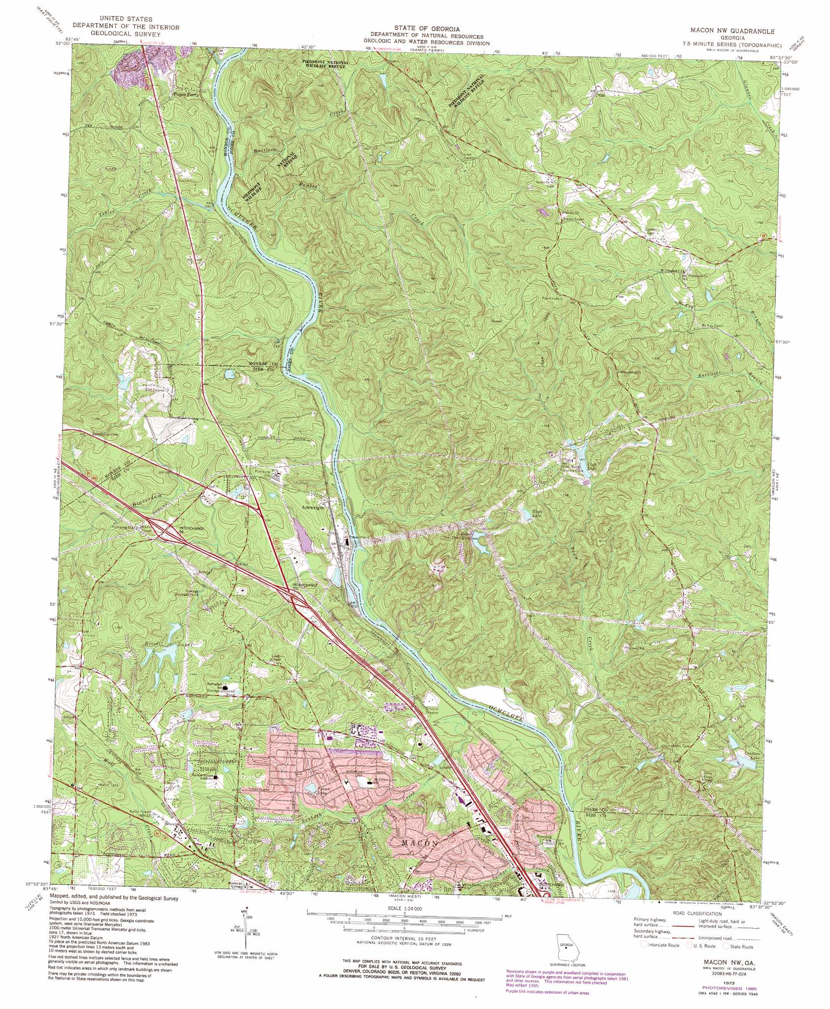
USGS Topo Quad 32083h6 - 1:24,000 scale
| Topo Map Name: | Macon Nw |
| USGS Topo Quad ID: | 32083h6 |
| Print Size: | ca. 21 1/4" wide x 27" high |
| Southeast Coordinates: | 32.875° N latitude / 83.625° W longitude |
| Map Center Coordinates: | 32.9375° N latitude / 83.6875° W longitude |
| U.S. State: | GA |
| Filename: | o32083h6.jpg |
| Download Map JPG Image: | Macon Nw topo map 1:24,000 scale |
| Map Type: | Topographic |
| Topo Series: | 7.5´ |
| Map Scale: | 1:24,000 |
| Source of Map Images: | United States Geological Survey (USGS) |
| Alternate Map Versions: |
Macon NW GA 1973, updated 1977 Download PDF Buy paper map Macon NW GA 1973, updated 1985 Download PDF Buy paper map Macon NW GA 2011 Download PDF Buy paper map Macon NW GA 2014 Download PDF Buy paper map |
1:24,000 Topo Quads surrounding Macon Nw
Indian Springs |
Berner |
Hillsboro |
Stanfordville |
Resseaus Crossroads |
Forsyth |
East Juliette |
Dames Ferry |
Gray |
Haddock |
Smarr |
Bolingbroke |
Macon Nw |
Macon Ne |
James |
Moran |
Lizella |
Macon West |
Macon East |
Dry Branch |
Knoxville |
Byron |
Warner Robins Nw |
Warner Robins Ne |
Marion |
> Back to 32083e1 at 1:100,000 scale
> Back to 32082a1 at 1:250,000 scale
> Back to U.S. Topo Maps home
Macon Nw topo map: Gazetteer
Macon Nw: Bars
Toms Shoals elevation 96m 314′Macon Nw: Crossings
Exit 55 elevation 107m 351′Exit 55A elevation 110m 360′
Exit 56 elevation 123m 403′
Holton Ferry (historical) elevation 92m 301′
Popes Ferry (historical) elevation 96m 314′
Toms Ford elevation 96m 314′
Macon Nw: Dams
Club Lake Dam elevation 128m 419′Coulters Lake Dam elevation 117m 383′
Howell Lake Dam elevation 123m 403′
Lake Deer Run Dam elevation 134m 439′
Rivoli Lake Dam elevation 123m 403′
Macon Nw: Mines
Macon Quarry elevation 132m 433′Macon Nw: Populated Places
Arkwright elevation 107m 351′Billingwood elevation 154m 505′
Castlegate elevation 139m 456′
Forest Lake elevation 133m 436′
Glen Cove elevation 120m 393′
Glenwood Forest elevation 130m 426′
Lokchapee elevation 124m 406′
McKibben Lane elevation 111m 364′
Parker (historical) elevation 101m 331′
Pine Forest elevation 118m 387′
Plentitude (historical) elevation 160m 524′
Riverside Park elevation 107m 351′
Riverview elevation 108m 354′
Rivoli (historical) elevation 147m 482′
Stratford Oaks elevation 120m 393′
Thornwood elevation 124m 406′
Three Points elevation 159m 521′
Wesleyan elevation 146m 479′
Wesleyan Estates elevation 147m 482′
Wesleyan Hills elevation 125m 410′
Wesleyan Woods elevation 128m 419′
Whitehouse Plantation elevation 142m 465′
Wimbish Hills elevation 130m 426′
Wimbish Wood elevation 123m 403′
Woodcrest elevation 156m 511′
Macon Nw: Reservoirs
Club Lake elevation 128m 419′Coulters Lake elevation 117m 383′
Eagle Lake elevation 137m 449′
Forest Lake elevation 112m 367′
Howell Lake elevation 123m 403′
Lake Deer Run elevation 134m 439′
Rivoli Lake elevation 123m 403′
Rivoli Lakes elevation 123m 403′
Macon Nw: Streams
Beaverdam Creek elevation 91m 298′Buttlers Creek elevation 97m 318′
Pratts Creek elevation 97m 318′
Rum Creek elevation 96m 314′
Sabbath Creek elevation 88m 288′
Savage Branch elevation 93m 305′
Tobler Creek elevation 96m 314′
Town Creek elevation 88m 288′
Macon Nw digital topo map on disk
Buy this Macon Nw topo map showing relief, roads, GPS coordinates and other geographical features, as a high-resolution digital map file on DVD:
South Carolina, Western North Carolina & Northeastern Georgia
Buy digital topo maps: South Carolina, Western North Carolina & Northeastern Georgia