Plains Topo Map Georgia
To zoom in, hover over the map of Plains
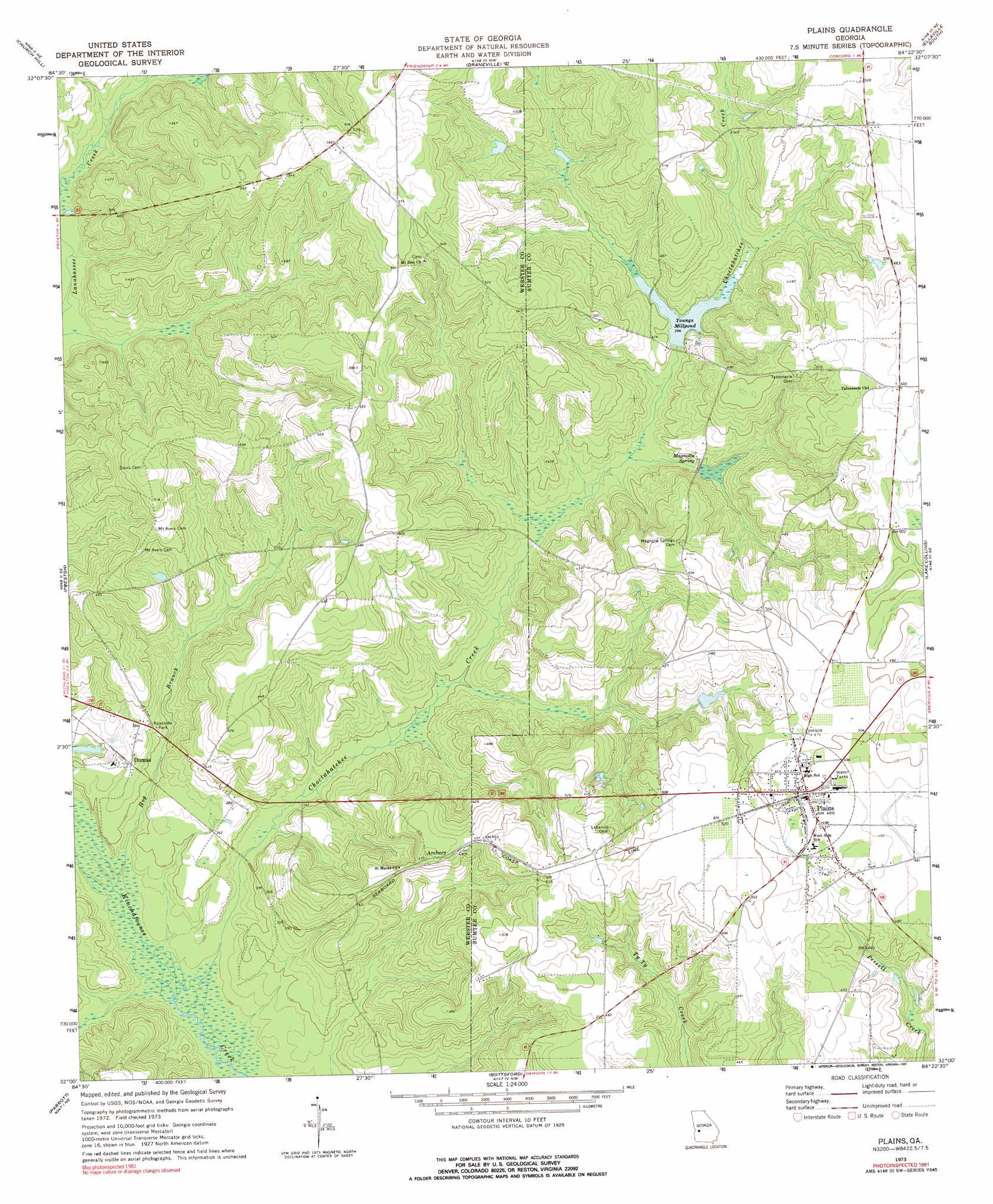
USGS Topo Quad 32084a4 - 1:24,000 scale
| Topo Map Name: | Plains |
| USGS Topo Quad ID: | 32084a4 |
| Print Size: | ca. 21 1/4" wide x 27" high |
| Southeast Coordinates: | 32° N latitude / 84.375° W longitude |
| Map Center Coordinates: | 32.0625° N latitude / 84.4375° W longitude |
| U.S. State: | GA |
| Filename: | o32084a4.jpg |
| Download Map JPG Image: | Plains topo map 1:24,000 scale |
| Map Type: | Topographic |
| Topo Series: | 7.5´ |
| Map Scale: | 1:24,000 |
| Source of Map Images: | United States Geological Survey (USGS) |
| Alternate Map Versions: |
Plains GA 1973, updated 1975 Download PDF Buy paper map Plains GA 1973, updated 1991 Download PDF Buy paper map Plains GA 2011 Download PDF Buy paper map Plains GA 2014 Download PDF Buy paper map |
1:24,000 Topo Quads surrounding Plains
Glen Alta |
Buena Vista |
Tazewell South |
Ellaville North |
Ideal South |
Brooklyn |
Church Hill |
Draneville |
Ellaville South |
Andersonville |
Richland |
Preston |
Plains |
Lake Collins |
Americus |
Benevolence |
Parrott |
Bottsford |
Smithville West |
Smithville East |
Brooksville |
Shellman |
Dawson |
Bronwood |
Neyami |
> Back to 32084a1 at 1:100,000 scale
> Back to 32084a1 at 1:250,000 scale
> Back to U.S. Topo Maps home
Plains topo map: Gazetteer
Plains: Dams
Hagerson Lake Dam elevation 125m 410′Youngs Millpond Dam elevation 120m 393′
Plains: Parks
Jimmy Carter National Historic Site elevation 144m 472′Logan Park elevation 152m 498′
Plains City Park elevation 153m 501′
Plains Historic District elevation 153m 501′
Plains: Populated Places
Archery elevation 145m 475′Dumas elevation 112m 367′
Lebanon (historical) elevation 157m 515′
Magnolia Springs (historical) elevation 147m 482′
Plains elevation 152m 498′
Plains: Post Offices
Plains Post Office elevation 152m 498′Plains: Reservoirs
Hagerson Lake elevation 125m 410′Youngs Millpond elevation 120m 393′
Plains: Springs
Magnolia Spring elevation 121m 396′Plains: Streams
Choctahatchee Creek elevation 97m 318′Hog Branch elevation 97m 318′
Rabbit Branch elevation 106m 347′
Plains digital topo map on disk
Buy this Plains topo map showing relief, roads, GPS coordinates and other geographical features, as a high-resolution digital map file on DVD:
Gulf Coast (LA, MS, AL, FL) & Southwestern Georgia
Buy digital topo maps: Gulf Coast (LA, MS, AL, FL) & Southwestern Georgia
 & Southwestern Georgia map DVD")