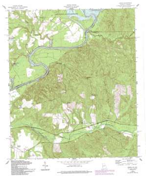
Union Topo Map Georgia
To zoom in, hover over the map of Union
USGS Topo Quad 32084b8 - 1:24,000 scale
| Topo Map Name: | Union |
| USGS Topo Quad ID: | 32084b8 |
| Print Size: | ca. 21 1/4" wide x 27" high |
| Southeast Coordinates: | 32.125° N latitude / 84.875° W longitude |
| Map Center Coordinates: | 32.1875° N latitude / 84.9375° W longitude |
| U.S. States: | GA, AL |
| Filename: | o32084b8.jpg |
| Download Map JPG Image: | Union topo map 1:24,000 scale |
| Map Type: | Topographic |
| Topo Series: | 7.5´ |
| Map Scale: | 1:24,000 |
| Source of Map Images: | United States Geological Survey (USGS) |
| Alternate Map Versions: |
Julia GA 1949 Download PDF Buy paper map Union GA 1955, updated 1959 Download PDF Buy paper map Union GA 1955, updated 1994 Download PDF Buy paper map Union GA 2011 Download PDF Buy paper map Union GA 2014 Download PDF Buy paper map |
1:24,000 Topo Quads surrounding Union
> Back to 32084a1 at 1:100,000 scale
> Back to 32084a1 at 1:250,000 scale
> Back to U.S. Topo Maps home
Union topo map: Gazetteer
Union: Parks
River Bend Park elevation 61m 200′Union: Populated Places
Blufftown (historical) elevation 115m 377′Childs Place elevation 101m 331′
Gillis Place elevation 130m 426′
Heard Place elevation 110m 360′
Orletta (historical) elevation 131m 429′
Perkins Place elevation 99m 324′
Power Place elevation 96m 314′
Union elevation 80m 262′
Upper Bradley Place elevation 76m 249′
Union: Reservoirs
Lonesome Duck Lake elevation 79m 259′Union: Streams
Dry Creek elevation 62m 203′Hichitee Creek elevation 58m 190′
Hollman Creek elevation 73m 239′
Ihagee Creek elevation 58m 190′
Sand Branch elevation 71m 232′
Snake Creek elevation 58m 190′
Union digital topo map on disk
Buy this Union topo map showing relief, roads, GPS coordinates and other geographical features, as a high-resolution digital map file on DVD:
Gulf Coast (LA, MS, AL, FL) & Southwestern Georgia
Buy digital topo maps: Gulf Coast (LA, MS, AL, FL) & Southwestern Georgia


