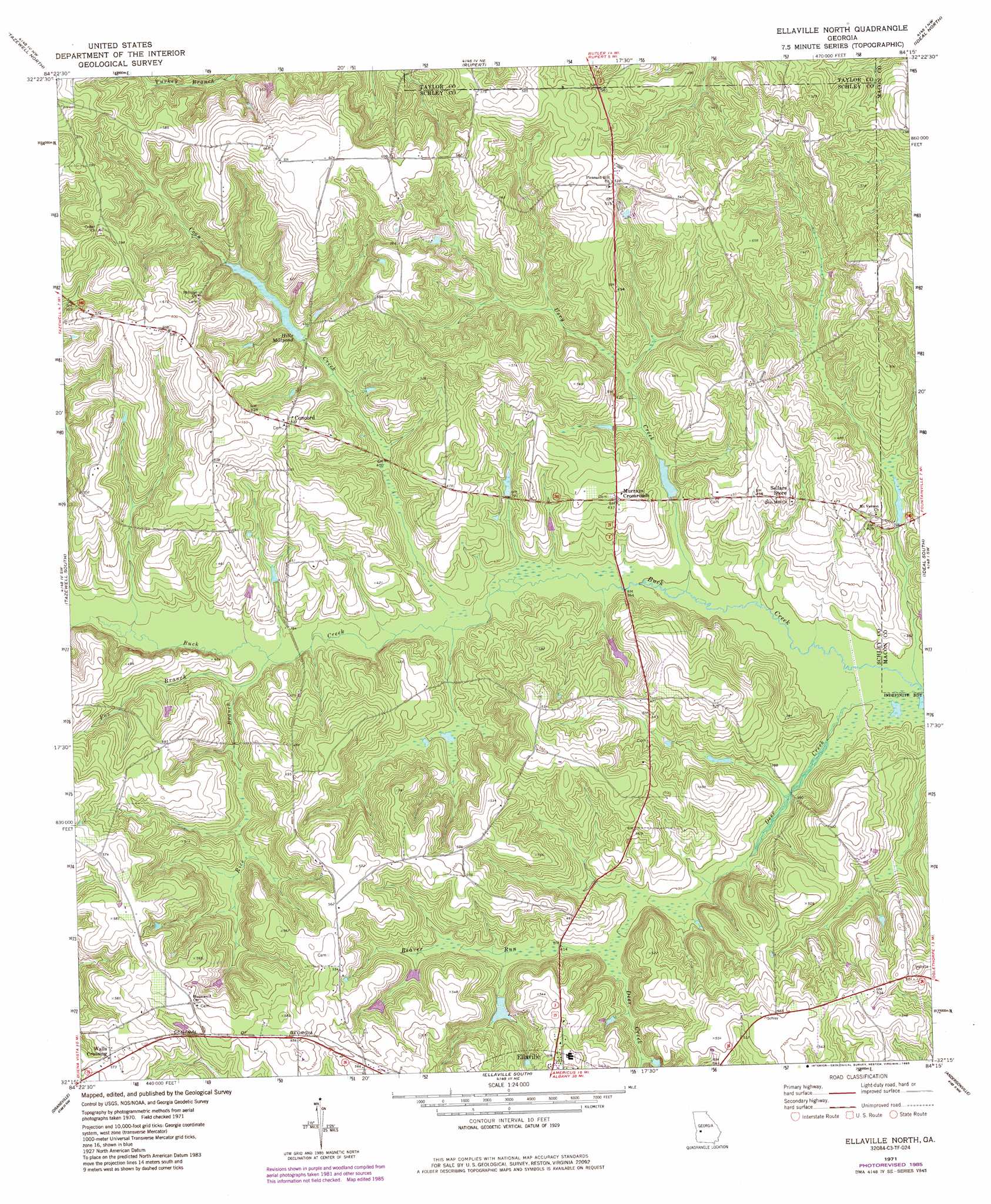
Ellaville North Topo Map Georgia
To zoom in, hover over the map of Ellaville North
USGS Topo Quad 32084c3 - 1:24,000 scale
| Topo Map Name: | Ellaville North |
| USGS Topo Quad ID: | 32084c3 |
| Print Size: | ca. 21 1/4" wide x 27" high |
| Southeast Coordinates: | 32.25° N latitude / 84.25° W longitude |
| Map Center Coordinates: | 32.3125° N latitude / 84.3125° W longitude |
| U.S. State: | GA |
| Filename: | o32084c3.jpg |
| Download Map JPG Image: | Ellaville North topo map 1:24,000 scale |
| Map Type: | Topographic |
| Topo Series: | 7.5´ |
| Map Scale: | 1:24,000 |
| Source of Map Images: | United States Geological Survey (USGS) |
| Alternate Map Versions: |
Ellaville North GA 1971, updated 1974 Download PDF Buy paper map Ellaville North GA 1971, updated 1985 Download PDF Buy paper map Ellaville North GA 2011 Download PDF Buy paper map Ellaville North GA 2014 Download PDF Buy paper map |
1:24,000 Topo Quads surrounding Ellaville North
Geneva |
Junction City |
Butler West |
Butler East |
Reynolds |
Buena Vista Ne |
Tazewell North |
Rupert |
Ideal North |
Garden Valley |
Buena Vista |
Tazewell South |
Ellaville North |
Ideal South |
Montezuma |
Church Hill |
Draneville |
Ellaville South |
Andersonville |
Pennington |
Preston |
Plains |
Lake Collins |
Americus |
Methvins |
> Back to 32084a1 at 1:100,000 scale
> Back to 32084a1 at 1:250,000 scale
> Back to U.S. Topo Maps home
Ellaville North topo map: Gazetteer
Ellaville North: Dams
American Legion Dam elevation 122m 400′Hill Dam elevation 144m 472′
Hills Millpond Dam elevation 128m 419′
Lanceford Lake Dam elevation 113m 370′
Owens Lake Dam elevation 117m 383′
Rufus Peepe Dam North elevation 138m 452′
Rufus Peepe Dam South elevation 160m 524′
Trice Lake Dam elevation 134m 439′
Ellaville North: Populated Places
Concord elevation 162m 531′Murrays Crossroads elevation 133m 436′
Walls Crossing elevation 176m 577′
Ellaville North: Reservoirs
American Legion Lake elevation 122m 400′Brays Mill Pond elevation 112m 367′
Hill Lake elevation 144m 472′
Hills Millpond elevation 128m 419′
Lanceford Lake elevation 113m 370′
Owens Lake elevation 117m 383′
Rufus Peepe Lake North elevation 138m 452′
Rufus Peepe Lake Suth elevation 160m 524′
Trice Lake elevation 134m 439′
Walls Fish Pond elevation 117m 383′
Ellaville North: Streams
Beaver Run elevation 123m 403′Coon Creek elevation 111m 364′
Deer Creek elevation 106m 347′
Fox Branch elevation 115m 377′
Rice Branch elevation 113m 370′
Usry Creek elevation 106m 347′
Ellaville North digital topo map on disk
Buy this Ellaville North topo map showing relief, roads, GPS coordinates and other geographical features, as a high-resolution digital map file on DVD:
Gulf Coast (LA, MS, AL, FL) & Southwestern Georgia
Buy digital topo maps: Gulf Coast (LA, MS, AL, FL) & Southwestern Georgia
 & Southwestern Georgia map DVD")