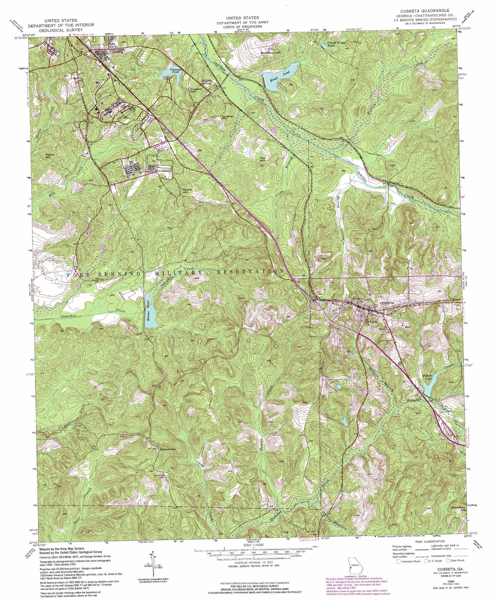
Cusseta Topo Map Georgia
To zoom in, hover over the map of Cusseta
USGS Topo Quad 32084c7 - 1:24,000 scale
| Topo Map Name: | Cusseta |
| USGS Topo Quad ID: | 32084c7 |
| Print Size: | ca. 21 1/4" wide x 27" high |
| Southeast Coordinates: | 32.25° N latitude / 84.75° W longitude |
| Map Center Coordinates: | 32.3125° N latitude / 84.8125° W longitude |
| U.S. State: | GA |
| Filename: | o32084c7.jpg |
| Download Map JPG Image: | Cusseta topo map 1:24,000 scale |
| Map Type: | Topographic |
| Topo Series: | 7.5´ |
| Map Scale: | 1:24,000 |
| Source of Map Images: | United States Geological Survey (USGS) |
| Alternate Map Versions: |
Cusseta GA 1949 Download PDF Buy paper map Cusseta GA 1955, updated 1959 Download PDF Buy paper map Cusseta GA 1955, updated 1964 Download PDF Buy paper map Cusseta GA 1955, updated 1970 Download PDF Buy paper map Cusseta GA 1955, updated 1984 Download PDF Buy paper map Cusseta GA 1955, updated 1994 Download PDF Buy paper map Cusseta GA 2011 Download PDF Buy paper map Cusseta GA 2014 Download PDF Buy paper map |
1:24,000 Topo Quads surrounding Cusseta
Smiths Station |
Fortson |
Midland |
Upatoi |
Geneva |
Phenix City |
Columbus |
Ochillee |
Buena Vista Nw |
Buena Vista Ne |
Fort Mitchell |
Fort Benning |
Cusseta |
Glen Alta |
Buena Vista |
Omaha |
Union |
Louvale |
Brooklyn |
Church Hill |
Twin Springs |
Lumpkin Sw |
Lumpkin |
Richland |
Preston |
> Back to 32084a1 at 1:100,000 scale
> Back to 32084a1 at 1:250,000 scale
> Back to U.S. Topo Maps home
Cusseta topo map: Gazetteer
Cusseta: Dams
Kings Pond Dam elevation 99m 324′Millers Lake Dam elevation 105m 344′
Victory Pond Dam elevation 94m 308′
Weems Pond Dam elevation 89m 291′
Cusseta: Populated Places
Central Springs elevation 94m 308′Cusseta elevation 162m 531′
Halloca (historical) elevation 97m 318′
Jamestown elevation 140m 459′
Cusseta: Post Offices
Cusseta Post Office elevation 150m 492′Cusseta: Reservoirs
Gordy Pond elevation 109m 357′Kings Pond elevation 94m 308′
Kisseck Pond (historical) elevation 106m 347′
Millers Lake elevation 105m 344′
Schley Pond (historical) elevation 94m 308′
Upper Kings Pond elevation 103m 337′
Victoria Pond elevation 96m 314′
Victory Pond elevation 100m 328′
Weems Pond elevation 89m 291′
Cusseta: Springs
Sulphur Spring elevation 105m 344′Cusseta: Streams
Bagley Creek elevation 103m 337′Cooks Branch elevation 91m 298′
Halloca Creek elevation 93m 305′
Hewell Creek elevation 87m 285′
Little Hichitee Creek elevation 90m 295′
Spring Branch elevation 97m 318′
Stevens Branch elevation 100m 328′
Cusseta: Summits
Bardman Hill elevation 123m 403′Craston Hill elevation 120m 393′
McKenna Hill elevation 131m 429′
Ray Hill elevation 126m 413′
Reeve Hill elevation 97m 318′
Ryans Hill elevation 121m 396′
Cusseta digital topo map on disk
Buy this Cusseta topo map showing relief, roads, GPS coordinates and other geographical features, as a high-resolution digital map file on DVD:
Gulf Coast (LA, MS, AL, FL) & Southwestern Georgia
Buy digital topo maps: Gulf Coast (LA, MS, AL, FL) & Southwestern Georgia
 & Southwestern Georgia map DVD")