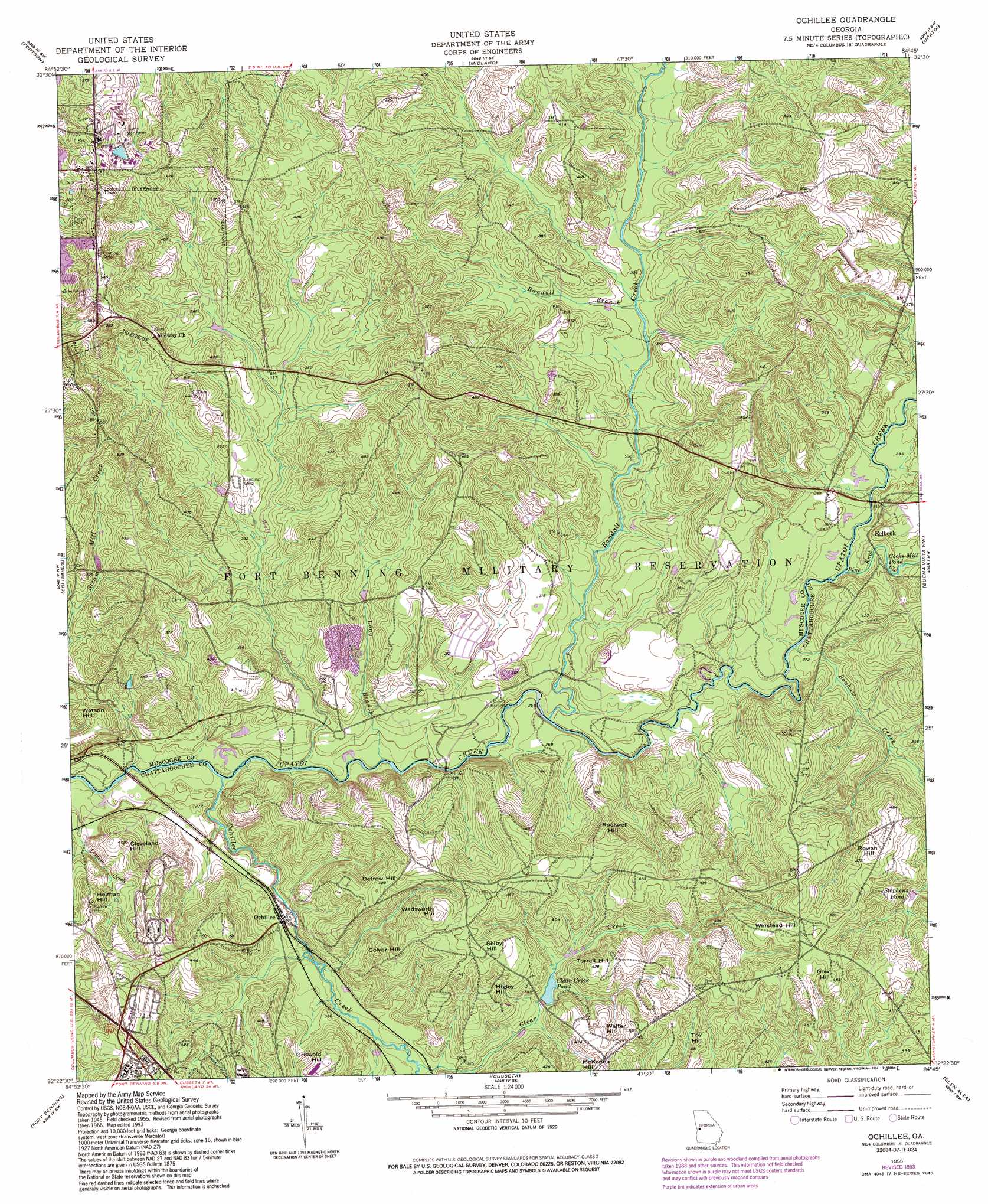
Ochillee Topo Map Georgia
To zoom in, hover over the map of Ochillee
USGS Topo Quad 32084d7 - 1:24,000 scale
| Topo Map Name: | Ochillee |
| USGS Topo Quad ID: | 32084d7 |
| Print Size: | ca. 21 1/4" wide x 27" high |
| Southeast Coordinates: | 32.375° N latitude / 84.75° W longitude |
| Map Center Coordinates: | 32.4375° N latitude / 84.8125° W longitude |
| U.S. State: | GA |
| Filename: | o32084d7.jpg |
| Download Map JPG Image: | Ochillee topo map 1:24,000 scale |
| Map Type: | Topographic |
| Topo Series: | 7.5´ |
| Map Scale: | 1:24,000 |
| Source of Map Images: | United States Geological Survey (USGS) |
| Alternate Map Versions: |
Ochillee GA 1949 Download PDF Buy paper map Ochillee GA 1955, updated 1959 Download PDF Buy paper map Ochillee GA 1955, updated 1964 Download PDF Buy paper map Ochillee GA 1955, updated 1970 Download PDF Buy paper map Ochillee GA 1955, updated 1986 Download PDF Buy paper map Ochillee GA 1955, updated 1994 Download PDF Buy paper map Ochillee GA 2011 Download PDF Buy paper map Ochillee GA 2014 Download PDF Buy paper map |
1:24,000 Topo Quads surrounding Ochillee
Bartletts Ferry Dam |
Mulberry Grove |
Cataula |
Waverly Hall |
Talbotton |
Smiths Station |
Fortson |
Midland |
Upatoi |
Geneva |
Phenix City |
Columbus |
Ochillee |
Buena Vista Nw |
Buena Vista Ne |
Fort Mitchell |
Fort Benning |
Cusseta |
Glen Alta |
Buena Vista |
Omaha |
Union |
Louvale |
Brooklyn |
Church Hill |
> Back to 32084a1 at 1:100,000 scale
> Back to 32084a1 at 1:250,000 scale
> Back to U.S. Topo Maps home
Ochillee topo map: Gazetteer
Ochillee: Bridges
McBrides Bridge elevation 73m 239′Ochillee: Crossings
McBride Ford elevation 106m 347′Turkey Ford elevation 79m 259′
Ochillee: Lakes
Cooks Mill Pond elevation 85m 278′Ochillee: Populated Places
Eelbeck elevation 103m 337′Heineburg Village (historical) elevation 148m 485′
Muscogee Manor elevation 125m 410′
Ochillee elevation 83m 272′
Sun Hill elevation 111m 364′
Ochillee: Reservoirs
Clear Creek Pond elevation 97m 318′Stephens Pond elevation 110m 360′
Ochillee: Streams
Bonham Creek elevation 80m 262′Clear Creek elevation 85m 278′
Lemert Creek elevation 73m 239′
Long Branch elevation 71m 232′
Ochillee Creek elevation 67m 219′
Pine Knot Creek elevation 81m 265′
Randall Branch elevation 88m 288′
Randall Creek elevation 75m 246′
Wolf Creek elevation 70m 229′
Ochillee: Summits
Cleveland Hill elevation 123m 403′Colyer Hill elevation 138m 452′
Detrow Hill elevation 131m 429′
Gow Hill elevation 147m 482′
Griswold Hill elevation 127m 416′
Herman Hill elevation 124m 406′
Higley Hill elevation 132m 433′
Rockwell Hill elevation 143m 469′
Rowan Hill elevation 144m 472′
Selby Hill elevation 141m 462′
Torrell Hill elevation 132m 433′
Toy Hill elevation 129m 423′
Wadsworth Hill elevation 147m 482′
Walter Hill elevation 131m 429′
Watson Hill elevation 116m 380′
Winstead Hill elevation 145m 475′
Ochillee digital topo map on disk
Buy this Ochillee topo map showing relief, roads, GPS coordinates and other geographical features, as a high-resolution digital map file on DVD:
Gulf Coast (LA, MS, AL, FL) & Southwestern Georgia
Buy digital topo maps: Gulf Coast (LA, MS, AL, FL) & Southwestern Georgia
 & Southwestern Georgia map DVD")