Columbus Topo Map Georgia
To zoom in, hover over the map of Columbus
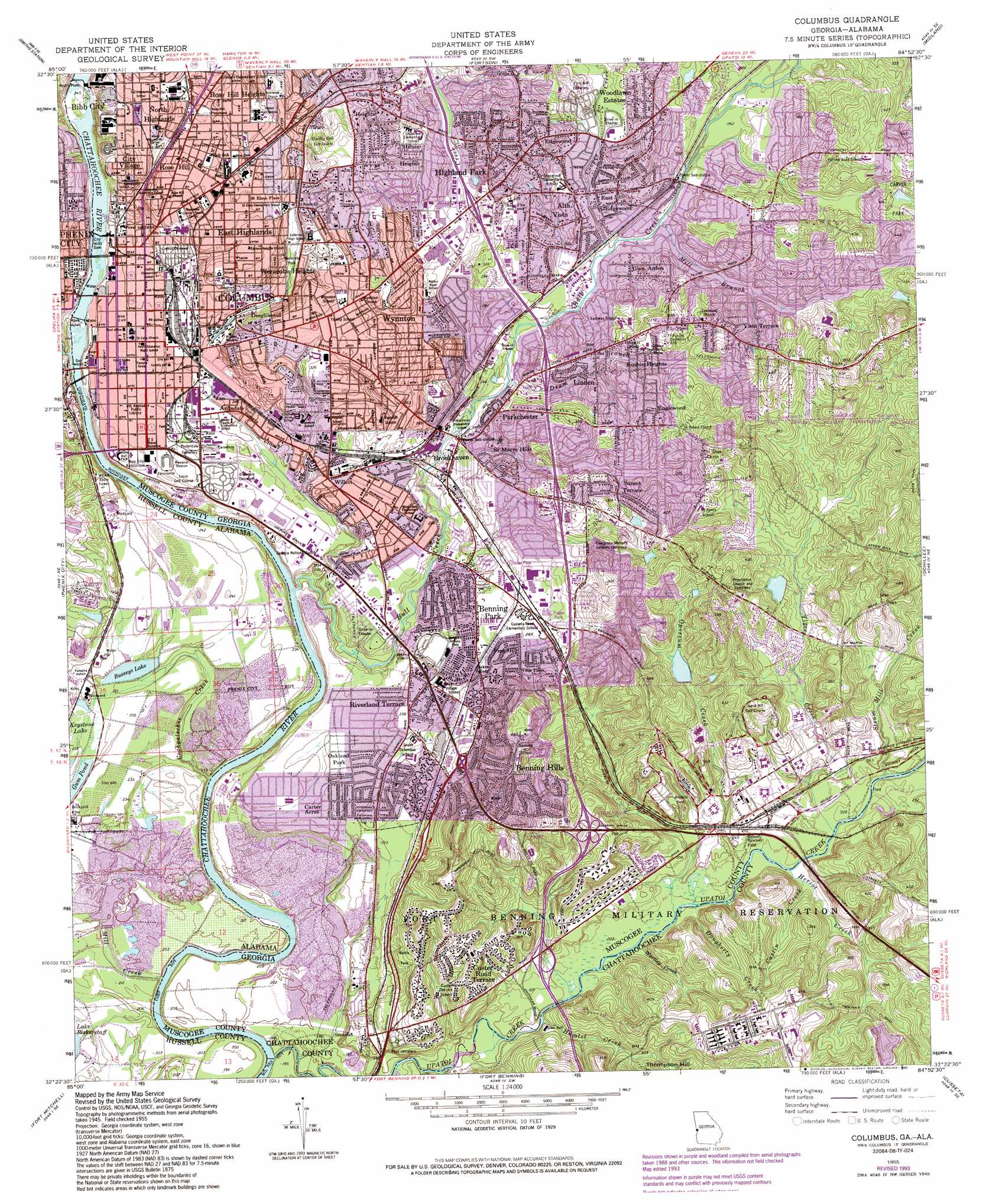
USGS Topo Quad 32084d8 - 1:24,000 scale
| Topo Map Name: | Columbus |
| USGS Topo Quad ID: | 32084d8 |
| Print Size: | ca. 21 1/4" wide x 27" high |
| Southeast Coordinates: | 32.375° N latitude / 84.875° W longitude |
| Map Center Coordinates: | 32.4375° N latitude / 84.9375° W longitude |
| U.S. States: | GA, AL |
| Filename: | o32084d8.jpg |
| Download Map JPG Image: | Columbus topo map 1:24,000 scale |
| Map Type: | Topographic |
| Topo Series: | 7.5´ |
| Map Scale: | 1:24,000 |
| Source of Map Images: | United States Geological Survey (USGS) |
| Alternate Map Versions: |
Columbus GA 1949 Download PDF Buy paper map Columbus GA 1955, updated 1959 Download PDF Buy paper map Columbus GA 1955, updated 1970 Download PDF Buy paper map Columbus GA 1955, updated 1975 Download PDF Buy paper map Columbus GA 1955, updated 1986 Download PDF Buy paper map Columbus GA 1955, updated 1993 Download PDF Buy paper map Columbus GA 1999, updated 2001 Download PDF Buy paper map Columbus GA 2011 Download PDF Buy paper map Columbus GA 2014 Download PDF Buy paper map |
1:24,000 Topo Quads surrounding Columbus
Beulah |
Bartletts Ferry Dam |
Mulberry Grove |
Cataula |
Waverly Hall |
Bleecker |
Smiths Station |
Fortson |
Midland |
Upatoi |
Crawford |
Phenix City |
Columbus |
Ochillee |
Buena Vista Nw |
Seale |
Fort Mitchell |
Fort Benning |
Cusseta |
Glen Alta |
Pittsview |
Omaha |
Union |
Louvale |
Brooklyn |
> Back to 32084a1 at 1:100,000 scale
> Back to 32084a1 at 1:250,000 scale
> Back to U.S. Topo Maps home
Columbus topo map: Gazetteer
Columbus: Airports
The Medical Center Heliport elevation 97m 318′Columbus: Bridges
General James Edward Oglethorpe Bridge elevation 57m 187′Columbus: Crossings
Interchange 1 elevation 104m 341′Interchange 2 elevation 94m 308′
Interchange 3 elevation 93m 305′
Interchange 4 elevation 82m 269′
Columbus: Dams
Bussey Lake Dam elevation 69m 226′Carver Park Dam elevation 133m 436′
City Mills Dam elevation 69m 226′
City Mills Dam elevation 69m 226′
Crescent Lake Dam elevation 76m 249′
Eagle Phenix Dam elevation 65m 213′
Opossum Lake Dam elevation 105m 344′
Twilight Pond Dam elevation 105m 344′
Columbus: Parks
Battle Park elevation 96m 314′Bennett Baseball Field elevation 75m 246′
Carver Park elevation 121m 396′
Columbus Historic District elevation 74m 242′
Columbus Riverfront Industrial Historic District elevation 103m 337′
Golden Ball Park elevation 71m 232′
Lindsey Park elevation 110m 360′
Lower Twentieth Street Residential Historic District elevation 84m 275′
McKenny Athletic Field elevation 77m 252′
Memorial Stadium elevation 73m 239′
North Recreation Center elevation 93m 305′
Rose Hill Playground elevation 103m 337′
South Lumpkin Park elevation 69m 226′
Weracoba Park elevation 79m 259′
Columbus: Populated Places
Allison Estates elevation 124m 406′Alta Vista elevation 84m 275′
Amber Acres elevation 113m 370′
Andrew Woods elevation 74m 242′
Averett Woods elevation 108m 354′
Avondale elevation 74m 242′
Avondale Heights elevation 71m 232′
Baker Village elevation 78m 255′
Battle Forest elevation 120m 393′
Battle Park elevation 108m 354′
Belvedere Park elevation 108m 354′
Benning Hills elevation 138m 452′
Benning Park elevation 79m 259′
Bibb City elevation 96m 314′
Booker Washington Heights elevation 126m 413′
Boxwood Estates elevation 88m 288′
Branton Woods elevation 95m 311′
Briarwood elevation 95m 311′
Broadmoor elevation 72m 236′
Brookhaven elevation 73m 239′
Brookridge elevation 123m 403′
Buena Vista Heights elevation 133m 436′
Carriage Estates elevation 76m 249′
Carter Acres elevation 69m 226′
Carver Heights elevation 88m 288′
Cedar Hills elevation 119m 390′
Cherokee Park elevation 69m 226′
City View Heights elevation 112m 367′
City Village elevation 99m 324′
Clubview Heights elevation 113m 370′
Colonial Park elevation 69m 226′
Columbia Heights elevation 146m 479′
Columbus elevation 74m 242′
Crossgate elevation 94m 308′
Cusseta Heights elevation 90m 295′
Custer Road Terrace elevation 108m 354′
Dawson Estates elevation 97m 318′
Dimon Head elevation 97m 318′
Dimon Woods elevation 110m 360′
Dinglewood elevation 101m 331′
East Edgewood elevation 80m 262′
East Highlands elevation 99m 324′
East Lakes elevation 99m 324′
East Urban Heights elevation 102m 334′
Edgewood elevation 91m 298′
Edgewood Forest elevation 92m 301′
Edgewood Terrace elevation 81m 265′
Englewood elevation 125m 410′
Esquiline (historical) elevation 96m 314′
Esquiline Heights elevation 113m 370′
Farrwood Park elevation 94m 308′
Floyd Grove elevation 100m 328′
Forest Heights elevation 95m 311′
Forest Hills elevation 119m 390′
Forest Park elevation 126m 413′
Forestdale elevation 85m 278′
Franklin Acres elevation 109m 357′
Garrett Heights elevation 95m 311′
Georgetown elevation 120m 393′
Glen Arden elevation 81m 265′
Hampton Heights elevation 101m 331′
Highland Park elevation 100m 328′
Hillside Terrace elevation 109m 357′
Hilton Heights elevation 104m 341′
Holiday Park elevation 100m 328′
Holly Hills elevation 82m 269′
Holly Woods elevation 86m 282′
Lake Rushin Heights elevation 99m 324′
Levy elevation 83m 272′
Linden elevation 83m 272′
Lindsey Park elevation 78m 255′
Magnolia Grove elevation 86m 282′
McGraw Manor elevation 81m 265′
Meadow Wood Park elevation 98m 321′
Merrywood elevation 90m 295′
Mount Vernon elevation 131m 429′
Muscogee elevation 79m 259′
North Highlands elevation 105m 344′
Northstar elevation 109m 357′
Oakland Park elevation 70m 229′
Parkchester elevation 105m 344′
Parkwood elevation 119m 390′
Pembrook elevation 82m 269′
Pine Hill elevation 79m 259′
Pinewood elevation 114m 374′
Pleasantview elevation 123m 403′
Quail Creek elevation 137m 449′
Regency Park elevation 82m 269′
Ridgefield Heights elevation 115m 377′
Ridgeview Heights elevation 78m 255′
Riverland Terrace elevation 72m 236′
Roosevelt Heights elevation 120m 393′
Rose Hill elevation 100m 328′
Rose Hill Heights elevation 116m 380′
Rosewood elevation 77m 252′
Saint Marys Hills elevation 85m 278′
Sand Hill elevation 77m 252′
Sheraton Forest elevation 92m 301′
Starmount elevation 77m 252′
Sunset Terrace elevation 94m 308′
Tara elevation 106m 347′
Taylors Woods elevation 112m 367′
Valley Hills elevation 104m 341′
Vista Terrace elevation 111m 364′
Wellington elevation 97m 318′
Weracoba Heights elevation 86m 282′
Wesley Heights elevation 126m 413′
Wesley Woods elevation 100m 328′
Wickham Heights elevation 106m 347′
Willett elevation 78m 255′
Willis Plaza elevation 83m 272′
Woodlawn Estates elevation 94m 308′
Wynnton elevation 92m 301′
Wynnton Grove elevation 109m 357′
Columbus: Post Offices
Columbus Post Office elevation 75m 246′Columbus: Reservoirs
Beaver Pond elevation 59m 193′Busseys Lake elevation 69m 226′
Carver Park Lake elevation 133m 436′
Chattahoochee River Reservoir elevation 69m 226′
Crescent Lake elevation 76m 249′
Head Lake elevation 109m 357′
Hidden Lake elevation 82m 269′
Keystone Lake elevation 70m 229′
Opossum Lake elevation 105m 344′
Twilight Pond elevation 105m 344′
Columbus: Streams
Armory Creek elevation 58m 190′Bull Creek elevation 58m 190′
Castin Creek elevation 67m 219′
Cochgalechee Creek elevation 55m 180′
Cooper Creek elevation 75m 246′
Dougherty Creek elevation 64m 209′
Dram Branch elevation 69m 226′
Hamlet Creek elevation 60m 196′
Heriot Creek elevation 66m 216′
Lindsey Creek elevation 69m 226′
Mill Branch elevation 76m 249′
Mill Creek elevation 54m 177′
Mill Creek elevation 58m 190′
Opossum Creek elevation 76m 249′
Sherwood Creek elevation 69m 226′
Steam Mill Creek elevation 66m 216′
Tiger Creek elevation 67m 219′
Upatoi Creek elevation 54m 177′
Werocoda Creek elevation 57m 187′
Wortley Creek elevation 63m 206′
Columbus digital topo map on disk
Buy this Columbus topo map showing relief, roads, GPS coordinates and other geographical features, as a high-resolution digital map file on DVD:
Gulf Coast (LA, MS, AL, FL) & Southwestern Georgia
Buy digital topo maps: Gulf Coast (LA, MS, AL, FL) & Southwestern Georgia
 & Southwestern Georgia map DVD")