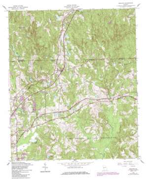
Midland Topo Map Georgia
To zoom in, hover over the map of Midland
USGS Topo Quad 32084e7 - 1:24,000 scale
| Topo Map Name: | Midland |
| USGS Topo Quad ID: | 32084e7 |
| Print Size: | ca. 21 1/4" wide x 27" high |
| Southeast Coordinates: | 32.5° N latitude / 84.75° W longitude |
| Map Center Coordinates: | 32.5625° N latitude / 84.8125° W longitude |
| U.S. State: | GA |
| Filename: | o32084e7.jpg |
| Download Map JPG Image: | Midland topo map 1:24,000 scale |
| Map Type: | Topographic |
| Topo Series: | 7.5´ |
| Map Scale: | 1:24,000 |
| Source of Map Images: | United States Geological Survey (USGS) |
| Alternate Map Versions: |
Midland GA 1949 Download PDF Buy paper map Midland GA 1955, updated 1959 Download PDF Buy paper map Midland GA 1955, updated 1970 Download PDF Buy paper map Midland GA 1955, updated 1983 Download PDF Buy paper map Midland GA 1955, updated 1986 Download PDF Buy paper map Midland GA 2011 Download PDF Buy paper map Midland GA 2014 Download PDF Buy paper map |
1:24,000 Topo Quads surrounding Midland
> Back to 32084e1 at 1:100,000 scale
> Back to 32084a1 at 1:250,000 scale
> Back to U.S. Topo Maps home
Midland topo map: Gazetteer
Midland: Airports
Pratt and Whitney Aircraft Heliport elevation 128m 419′Midland: Dams
Bull Creek Watershed Dam Number 21 elevation 142m 465′Bull Creek Watershed Structure Number 24 Dam elevation 99m 324′
Cunningham Lake Dam elevation 167m 547′
Deer Run Lake Dam elevation 192m 629′
Faulkner Lake Dam elevation 162m 531′
Fieldcrest Lake Dam elevation 175m 574′
Gates Dam elevation 125m 410′
Hardaway Dam elevation 132m 433′
Hedleys Pond Dam elevation 116m 380′
Jenkins Dam elevation 140m 459′
Mahaffey Lake Dam elevation 190m 623′
Spring Head Lake Dam elevation 202m 662′
Stonewall Jackson Dam elevation 152m 498′
Thornton Dam elevation 116m 380′
Woodruff Dam elevation 115m 377′
Woodruff Lake Dam elevation 177m 580′
Woodruff North Dam elevation 119m 390′
Midland: Lakes
Britton Ponds elevation 94m 308′Midland: Populated Places
Beaver Run elevation 128m 419′Commonwealth (historical) elevation 115m 377′
Flat Rock elevation 140m 459′
Foxrun elevation 126m 413′
Gordydale elevation 225m 738′
Midland elevation 168m 551′
Schatulga elevation 97m 318′
Midland: Reservoirs
Beaver Lake elevation 113m 370′Bonifay Lakes elevation 135m 442′
Bull Creek Reservoir Number 26 elevation 123m 403′
Bull Creek Reservoir Number One elevation 109m 357′
Bull Creek Watershed Lake Number 21 elevation 142m 465′
Bull Creek Watershed Lake Number 24 elevation 99m 324′
Cunningham Lake elevation 167m 547′
Debrabant Lake elevation 97m 318′
Deer Run Lake elevation 192m 629′
Faulkner Lake elevation 162m 531′
Fieldcrest Lake elevation 175m 574′
Gates Lake elevation 125m 410′
Hardaway Lake elevation 132m 433′
Hedleys Pond elevation 116m 380′
Jenkins Lake elevation 140m 459′
Kitten Lake elevation 120m 393′
Lake Cora elevation 169m 554′
Lake Pines elevation 119m 390′
Mahaffey Lake elevation 190m 623′
Medleys Pond elevation 114m 374′
Spring Head Lake elevation 202m 662′
Stonewall Jackson Lake elevation 152m 498′
Thornton Lake elevation 116m 380′
Widgeon Lake elevation 116m 380′
Willis Lake elevation 202m 662′
Woodruff Lake elevation 177m 580′
Woodruff Lake elevation 115m 377′
Woodruff North Lake elevation 119m 390′
Midland: Streams
Dozier Creek elevation 94m 308′Midland digital topo map on disk
Buy this Midland topo map showing relief, roads, GPS coordinates and other geographical features, as a high-resolution digital map file on DVD:
Gulf Coast (LA, MS, AL, FL) & Southwestern Georgia
Buy digital topo maps: Gulf Coast (LA, MS, AL, FL) & Southwestern Georgia


