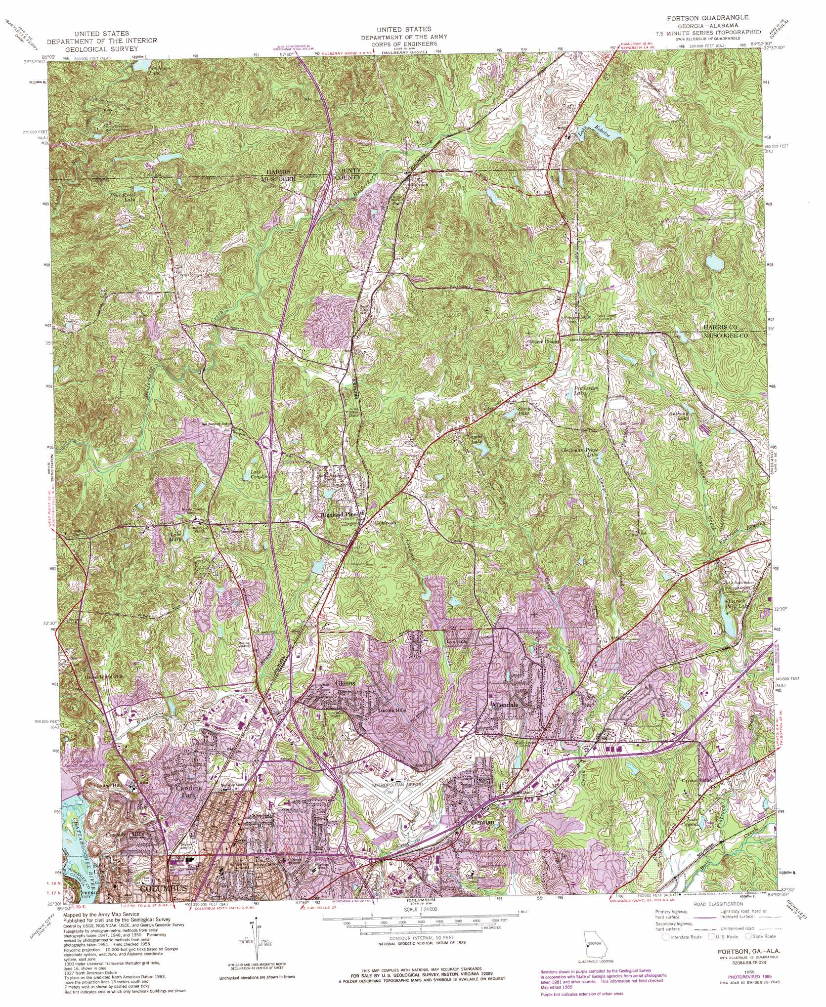
Fortson Topo Map Georgia
To zoom in, hover over the map of Fortson
USGS Topo Quad 32084e8 - 1:24,000 scale
| Topo Map Name: | Fortson |
| USGS Topo Quad ID: | 32084e8 |
| Print Size: | ca. 21 1/4" wide x 27" high |
| Southeast Coordinates: | 32.5° N latitude / 84.875° W longitude |
| Map Center Coordinates: | 32.5625° N latitude / 84.9375° W longitude |
| U.S. States: | GA, AL |
| Filename: | o32084e8.jpg |
| Download Map JPG Image: | Fortson topo map 1:24,000 scale |
| Map Type: | Topographic |
| Topo Series: | 7.5´ |
| Map Scale: | 1:24,000 |
| Source of Map Images: | United States Geological Survey (USGS) |
| Alternate Map Versions: |
Fortson GA 1950, updated 1953 Download PDF Buy paper map Fortson GA 1955, updated 1959 Download PDF Buy paper map Fortson GA 1955, updated 1970 Download PDF Buy paper map Fortson GA 1955, updated 1975 Download PDF Buy paper map Fortson GA 1955, updated 1986 Download PDF Buy paper map Fortson GA 2011 Download PDF Buy paper map Fortson GA 2014 Download PDF Buy paper map |
1:24,000 Topo Quads surrounding Fortson
Lanett South |
Whitesville |
Pine Mountain Sw |
Pine Mountain |
Shiloh |
Beulah |
Bartletts Ferry Dam |
Mulberry Grove |
Cataula |
Waverly Hall |
Bleecker |
Smiths Station |
Fortson |
Midland |
Upatoi |
Crawford |
Phenix City |
Columbus |
Ochillee |
Buena Vista Nw |
Seale |
Fort Mitchell |
Fort Benning |
Cusseta |
Glen Alta |
> Back to 32084e1 at 1:100,000 scale
> Back to 32084a1 at 1:250,000 scale
> Back to U.S. Topo Maps home
Fortson topo map: Gazetteer
Fortson: Airports
Columbus Metropolitan Airport elevation 118m 387′Fortson: Crossings
Interchange 5 elevation 110m 360′Interchange 6 elevation 119m 390′
Interchange 8 elevation 161m 528′
Interchange 9 elevation 143m 469′
Fortson: Dams
Bearden Dam elevation 134m 439′Bull Creek Watershed Dam Number 12 elevation 113m 370′
Bull Creek Watershed Dam Number 14 elevation 123m 403′
Bull Creek Watershed Dam Number 25 elevation 104m 341′
Bull Creek Watershed Dam Number 27 elevation 102m 334′
Bull Creek Watershed Dam Number 28 elevation 113m 370′
Bull Creek Watershed Dam Number Four elevation 120m 393′
Bull Creek Watershed Dam Number Three elevation 94m 308′
Cherokee Lake Dam elevation 130m 426′
Cooper Creek Dam elevation 105m 344′
Flat Rock Lake Dam elevation 110m 360′
Flatrock Park Dam elevation 114m 374′
Lake Kokoloe Dam elevation 167m 547′
Lindsey Creek Dam elevation 127m 416′
Oliver Dam elevation 102m 334′
Simpson Lake Dam elevation 158m 518′
Swifts Lake Dam elevation 165m 541′
Fortson: Mines
Barin Quarry elevation 159m 521′Fortson: Parks
Britt David Park elevation 125m 410′Cooper Creek Park elevation 100m 328′
Double Churches Park elevation 159m 521′
Heath Park elevation 115m 377′
Muscogee County Flatrock Park elevation 128m 419′
Fortson: Populated Places
Allendale elevation 130m 426′Arrowhead Estates elevation 120m 393′
Autumnridge elevation 137m 449′
Barin elevation 153m 501′
Beallwoods elevation 117m 383′
Beverly Heights elevation 120m 393′
Brookstone elevation 132m 433′
Brookview Estates elevation 98m 321′
Camelot elevation 111m 364′
Candlestick elevation 128m 419′
Caroline Park elevation 126m 413′
Cascade Hills elevation 141m 462′
Castlewood elevation 93m 305′
Charter Oaks elevation 132m 433′
Cheshire Valley elevation 132m 433′
Crescent Ridge elevation 122m 400′
Crystal Valley elevation 100m 328′
Double Churches elevation 160m 524′
Dover Hills elevation 122m 400′
Farmington elevation 97m 318′
Flat Rock Estates elevation 134m 439′
Fortson elevation 157m 515′
Fortson Terrace elevation 158m 518′
Fox Chapel elevation 130m 426′
Foxfire elevation 140m 459′
Gentian elevation 113m 370′
Georgian Hills elevation 95m 311′
Glenns elevation 154m 505′
Hearthstone elevation 132m 433′
Hidden Hills elevation 122m 400′
Highland Pines elevation 160m 524′
Hillbrook Estates elevation 137m 449′
Hunters Court elevation 145m 475′
Innsbrook elevation 143m 469′
Kenwood elevation 115m 377′
Kingston elevation 133m 436′
Kirkwood elevation 160m 524′
Lake Oliver Estates elevation 117m 383′
Lakeshore elevation 103m 337′
Laurel Hills elevation 146m 479′
Leesburg elevation 128m 419′
Lincoln Hills elevation 126m 413′
Lokey Estates elevation 161m 528′
Lyn Hills elevation 139m 456′
Maridale Estates elevation 124m 406′
Moores Forest elevation 166m 544′
Morningside elevation 132m 433′
Nankipooh elevation 160m 524′
North Kingston elevation 127m 416′
North Oaks elevation 126m 413′
Northgate elevation 98m 321′
Ogletree Woods elevation 147m 482′
Peppertree elevation 161m 528′
Ranch Forest elevation 150m 492′
Sears Woods elevation 97m 318′
Shenandoah Forest elevation 112m 367′
Spring Lake elevation 135m 442′
Spring Valley elevation 126m 413′
Sunshine Acres elevation 138m 452′
Timberdale elevation 159m 521′
Tulakes elevation 148m 485′
Twin Chapel elevation 140m 459′
Victory Heights elevation 174m 570′
Wayne Terrace elevation 112m 367′
Weems Valley elevation 147m 482′
Westgate elevation 110m 360′
Williamsburg elevation 133m 436′
Willow Bend elevation 93m 305′
Windsor Park elevation 117m 383′
Fortson: Reservoirs
Anglin Lake elevation 99m 324′Anthony Lake elevation 104m 341′
Anthony Lake elevation 147m 482′
Bearden Lake elevation 134m 439′
Billings Pond elevation 119m 390′
Bull Creek Reservoir Number 14 elevation 123m 403′
Bull Creek Watershed Lake Number 12 elevation 113m 370′
Bull Creek Watershed Lake Number 25 elevation 104m 341′
Bull Creek Watershed Lake Number 27 elevation 102m 334′
Bull Creek Watershed Lake Number 28 elevation 113m 370′
Bull Creek Watershed Lake Number Four elevation 120m 393′
Bull Creek Watershed Lake Number Three elevation 94m 308′
Chapman Pease Lake elevation 148m 485′
Charter Oaks Lake elevation 113m 370′
Cherokee Lake elevation 130m 426′
Clap Hill Reservoir elevation 145m 475′
Cooper Creek Reservoir elevation 105m 344′
Flat Rock Lake elevation 110m 360′
Flatrock Park Lake elevation 114m 374′
Heards Lake elevation 102m 334′
Kokoloe Lake elevation 167m 547′
Lake Arrowhead elevation 109m 357′
Lake Chaplin elevation 147m 482′
Lake Crystal elevation 96m 314′
Lake Forest elevation 147m 482′
Lake Ginger elevation 120m 393′
Lake Heath elevation 110m 360′
Lake Kokoloe elevation 167m 547′
Lake Mary elevation 145m 475′
Lake Oliver elevation 81m 265′
Lake Somerset elevation 110m 360′
Lambs Lake elevation 153m 501′
Lindsey Creek Reservoir elevation 127m 416′
Mirror Lake elevation 151m 495′
Pine Knoll Lake elevation 154m 505′
Simpson Lake elevation 158m 518′
Smith Lake elevation 119m 390′
Stevens Lake elevation 165m 541′
Story Lake elevation 165m 541′
Swifts Lake elevation 165m 541′
Weems Road Lake elevation 119m 390′
Fortson: Streams
Cooper Branch elevation 102m 334′Flatrock Branch elevation 124m 406′
Flatrock Creek elevation 82m 269′
Roaring Branch elevation 102m 334′
Fortson: Summits
Clapp Hill elevation 137m 449′Fortson digital topo map on disk
Buy this Fortson topo map showing relief, roads, GPS coordinates and other geographical features, as a high-resolution digital map file on DVD:
Gulf Coast (LA, MS, AL, FL) & Southwestern Georgia
Buy digital topo maps: Gulf Coast (LA, MS, AL, FL) & Southwestern Georgia
 & Southwestern Georgia map DVD")