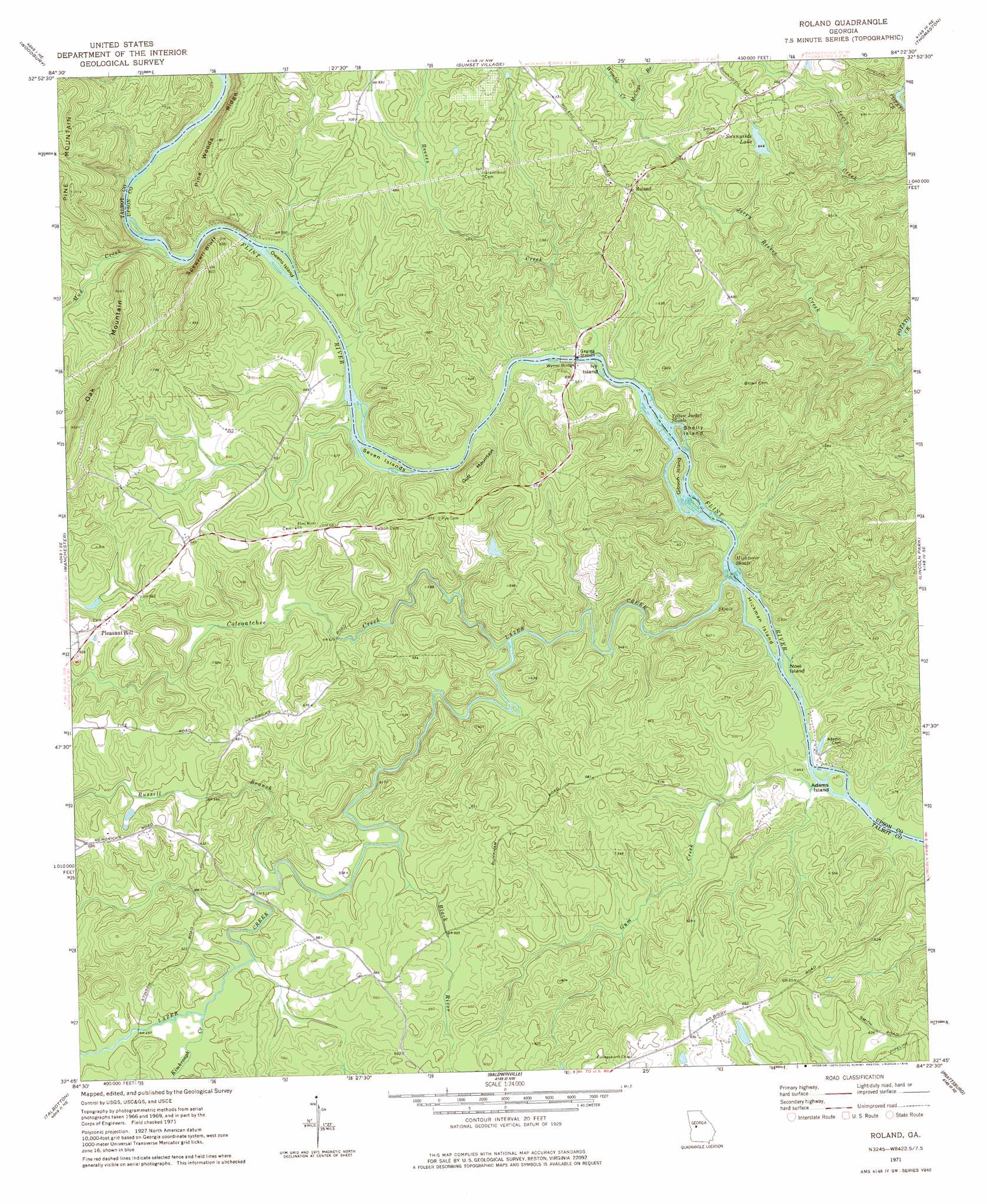
Roland Topo Map Georgia
To zoom in, hover over the map of Roland
USGS Topo Quad 32084g4 - 1:24,000 scale
| Topo Map Name: | Roland |
| USGS Topo Quad ID: | 32084g4 |
| Print Size: | ca. 21 1/4" wide x 27" high |
| Southeast Coordinates: | 32.75° N latitude / 84.375° W longitude |
| Map Center Coordinates: | 32.8125° N latitude / 84.4375° W longitude |
| U.S. State: | GA |
| Filename: | o32084g4.jpg |
| Download Map JPG Image: | Roland topo map 1:24,000 scale |
| Map Type: | Topographic |
| Topo Series: | 7.5´ |
| Map Scale: | 1:24,000 |
| Source of Map Images: | United States Geological Survey (USGS) |
| Alternate Map Versions: |
Roland GA 1971, updated 1973 Download PDF Buy paper map Roland GA 1971, updated 1978 Download PDF Buy paper map Roland GA 2011 Download PDF Buy paper map Roland GA 2014 Download PDF Buy paper map |
1:24,000 Topo Quads surrounding Roland
Greenville |
Gay |
Concord |
Zebulon |
Barnesville |
Warm Springs |
Woodbury |
Sunset Village |
Thomaston |
Yatesville |
Shiloh |
Manchester |
Roland |
Lincoln Park |
Logtown |
Waverly Hall |
Talbotton |
Baldwinville |
Prattsburg |
Fickling Mill |
Upatoi |
Geneva |
Junction City |
Butler West |
Butler East |
> Back to 32084e1 at 1:100,000 scale
> Back to 32084a1 at 1:250,000 scale
> Back to U.S. Topo Maps home
Roland topo map: Gazetteer
Roland: Bars
Hightower Shoals elevation 128m 419′Yellow Jacket Shoals elevation 146m 479′
Roland: Bridges
Wynns Bridge elevation 152m 498′Roland: Cliffs
Spewrell Bluff elevation 198m 649′Roland: Dams
Daniel Lake Dam elevation 173m 567′Franklins Pond Dam elevation 205m 672′
Hammonds Dam elevation 175m 574′
Hammonds Lake Dam elevation 199m 652′
Sunnyside Lake Dam elevation 198m 649′
Roland: Islands
Adams Island elevation 128m 419′Gibson Island elevation 156m 511′
Hickman Island elevation 128m 419′
Ivy Island elevation 151m 495′
Noel Island elevation 127m 416′
Owens Island elevation 168m 551′
Seven Islands elevation 160m 524′
Shelly Island elevation 160m 524′
Roland: Parks
Sprewell Bluff Park elevation 171m 561′Roland: Populated Places
Pleasant Hill elevation 215m 705′Roland elevation 218m 715′
Roland: Reservoirs
Daniel Lake elevation 173m 567′Franklins Pond elevation 205m 672′
Hammonds Lake elevation 175m 574′
Hammonds Lake elevation 199m 652′
Sunnyside Lake elevation 198m 649′
Roland: Streams
Black River elevation 145m 475′Coleoatchee Creek elevation 140m 459′
Gum Creek elevation 125m 410′
Kimbrough Creek elevation 150m 492′
Lazer Creek elevation 126m 413′
McCoys Branch elevation 194m 636′
Mud Creek elevation 170m 557′
Reeves Creek elevation 152m 498′
Russell Branch elevation 146m 479′
Womble Creek elevation 194m 636′
Roland: Summits
Gulf Mountain elevation 220m 721′Roland digital topo map on disk
Buy this Roland topo map showing relief, roads, GPS coordinates and other geographical features, as a high-resolution digital map file on DVD:
Gulf Coast (LA, MS, AL, FL) & Southwestern Georgia
Buy digital topo maps: Gulf Coast (LA, MS, AL, FL) & Southwestern Georgia
 & Southwestern Georgia map DVD")