Woodbury Topo Map Georgia
To zoom in, hover over the map of Woodbury
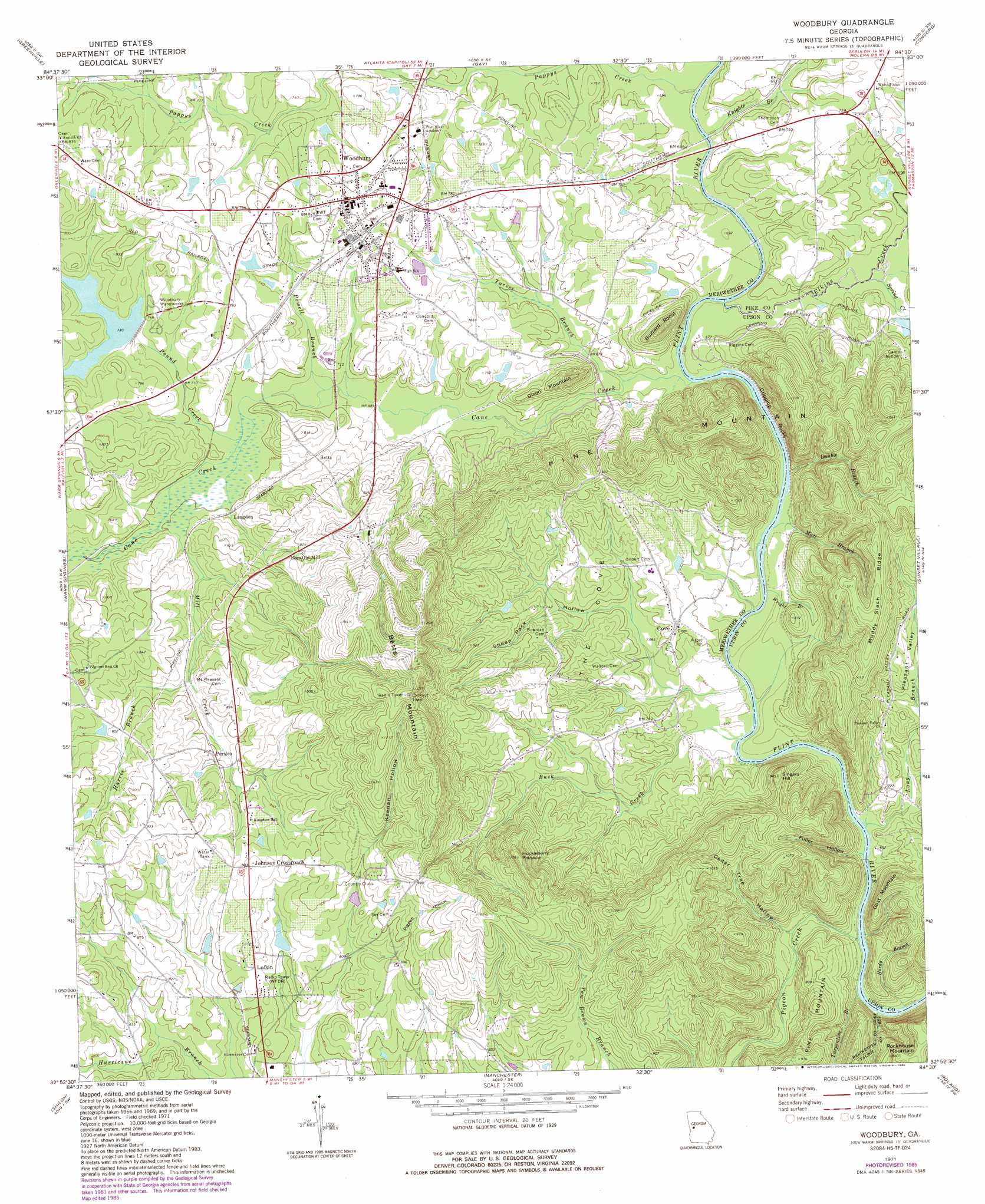
USGS Topo Quad 32084h5 - 1:24,000 scale
| Topo Map Name: | Woodbury |
| USGS Topo Quad ID: | 32084h5 |
| Print Size: | ca. 21 1/4" wide x 27" high |
| Southeast Coordinates: | 32.875° N latitude / 84.5° W longitude |
| Map Center Coordinates: | 32.9375° N latitude / 84.5625° W longitude |
| U.S. State: | GA |
| Filename: | o32084h5.jpg |
| Download Map JPG Image: | Woodbury topo map 1:24,000 scale |
| Map Type: | Topographic |
| Topo Series: | 7.5´ |
| Map Scale: | 1:24,000 |
| Source of Map Images: | United States Geological Survey (USGS) |
| Alternate Map Versions: |
Woodbury GA 1971, updated 1973 Download PDF Buy paper map Woodbury GA 2011 Download PDF Buy paper map Woodbury GA 2014 Download PDF Buy paper map |
1:24,000 Topo Quads surrounding Woodbury
Grantville |
Luthersville |
Haralson |
Hollonville |
Griffin South |
Odessadale |
Greenville |
Gay |
Concord |
Zebulon |
Durand |
Warm Springs |
Woodbury |
Sunset Village |
Thomaston |
Pine Mountain |
Shiloh |
Manchester |
Roland |
Lincoln Park |
Cataula |
Waverly Hall |
Talbotton |
Baldwinville |
Prattsburg |
> Back to 32084e1 at 1:100,000 scale
> Back to 32084a1 at 1:250,000 scale
> Back to U.S. Topo Maps home
Woodbury topo map: Gazetteer
Woodbury: Basins
The Cove elevation 220m 721′Woodbury: Bridges
Halls Bridge (historical) elevation 201m 659′Iron Bridge elevation 201m 659′
Riggins Bridge (historical) elevation 199m 652′
Woodbury: Cliffs
Dripping Rocks elevation 225m 738′Woodbury: Crossings
Girard Ford elevation 193m 633′Melton Ford elevation 195m 639′
Woodbury: Dams
Cane Creek Structure Number Two Dam elevation 219m 718′Carroll Dam elevation 236m 774′
Woodbury: Populated Places
Betts elevation 228m 748′Johnson Crossroads elevation 269m 882′
Langdon elevation 219m 718′
Loftin elevation 249m 816′
Persico elevation 246m 807′
Woodbury elevation 244m 800′
Woodbury: Reservoirs
Cane Creek Structure Number Two Lake elevation 219m 718′Carroll Lake elevation 236m 774′
Woodbury: Ridges
Muddy Slash Ridge elevation 350m 1148′Woodbury: Streams
Buck Creek elevation 192m 629′Cane Creek elevation 198m 649′
Double Branch elevation 197m 646′
Elkins Creek elevation 199m 652′
Hardy Branch elevation 187m 613′
Harris Branch elevation 225m 738′
Knights Branch elevation 201m 659′
Long Branch elevation 194m 636′
Matt Branch elevation 196m 643′
Mill Creek elevation 213m 698′
Pappys Creek elevation 201m 659′
Pigeon Creek elevation 187m 613′
Pound Creek elevation 211m 692′
Powell Branch elevation 205m 672′
Sheep Rock Hollow elevation 197m 646′
Spring Creek elevation 201m 659′
Spring Creek elevation 201m 659′
Tarver Branch elevation 200m 656′
Turpentine Branch elevation 188m 616′
Wright Branch elevation 195m 639′
Woodbury: Summits
Betts Mountain elevation 392m 1286′Buzzard Roost elevation 291m 954′
Dixon Mountain elevation 284m 931′
Goat Mountain elevation 287m 941′
Huckleberry Pinnacle elevation 355m 1164′
Rockhouse Mountain elevation 323m 1059′
Singers Hill elevation 300m 984′
Woodbury: Valleys
Cedar Tree Hollow elevation 195m 639′Fuller Hollow elevation 190m 623′
Keenan Hollow elevation 232m 761′
Pigpen Hollow elevation 246m 807′
Woodbury digital topo map on disk
Buy this Woodbury topo map showing relief, roads, GPS coordinates and other geographical features, as a high-resolution digital map file on DVD:
Gulf Coast (LA, MS, AL, FL) & Southwestern Georgia
Buy digital topo maps: Gulf Coast (LA, MS, AL, FL) & Southwestern Georgia
 & Southwestern Georgia map DVD")