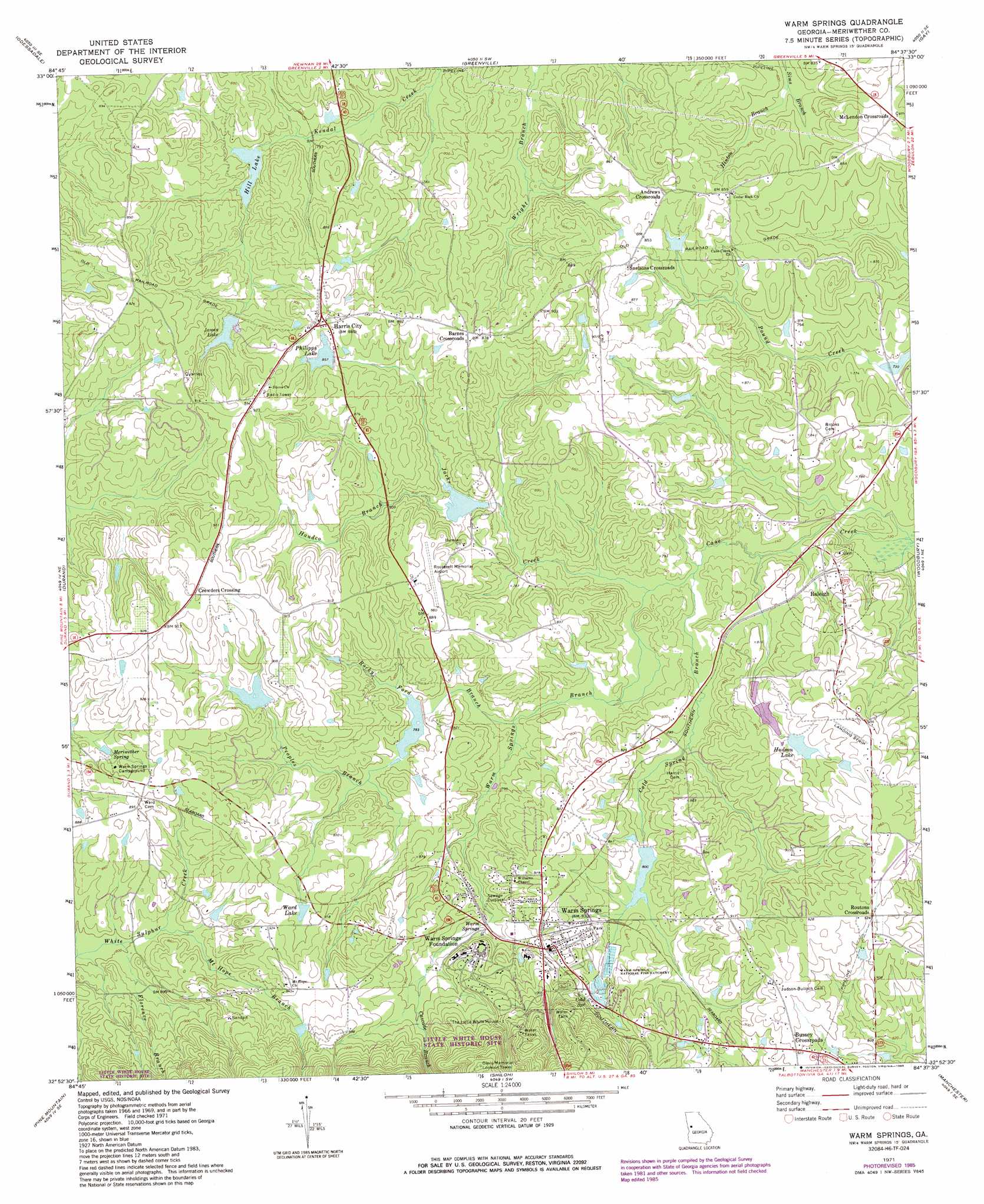
Warm Springs Topo Map Georgia
To zoom in, hover over the map of Warm Springs
USGS Topo Quad 32084h6 - 1:24,000 scale
| Topo Map Name: | Warm Springs |
| USGS Topo Quad ID: | 32084h6 |
| Print Size: | ca. 21 1/4" wide x 27" high |
| Southeast Coordinates: | 32.875° N latitude / 84.625° W longitude |
| Map Center Coordinates: | 32.9375° N latitude / 84.6875° W longitude |
| U.S. State: | GA |
| Filename: | o32084h6.jpg |
| Download Map JPG Image: | Warm Springs topo map 1:24,000 scale |
| Map Type: | Topographic |
| Topo Series: | 7.5´ |
| Map Scale: | 1:24,000 |
| Source of Map Images: | United States Geological Survey (USGS) |
| Alternate Map Versions: |
Warm Springs GA 1971, updated 1973 Download PDF Buy paper map Warm Springs GA 2011 Download PDF Buy paper map Warm Springs GA 2014 Download PDF Buy paper map |
1:24,000 Topo Quads surrounding Warm Springs
Hogansville |
Grantville |
Luthersville |
Haralson |
Hollonville |
Mountville |
Odessadale |
Greenville |
Gay |
Concord |
Hilyer |
Durand |
Warm Springs |
Woodbury |
Sunset Village |
Pine Mountain Sw |
Pine Mountain |
Shiloh |
Manchester |
Roland |
Mulberry Grove |
Cataula |
Waverly Hall |
Talbotton |
Baldwinville |
> Back to 32084e1 at 1:100,000 scale
> Back to 32084a1 at 1:250,000 scale
> Back to U.S. Topo Maps home
Warm Springs topo map: Gazetteer
Warm Springs: Airports
E H Hutton Airstrip elevation 279m 915′Roosevelt Memorial Airport elevation 251m 823′
Warm Springs: Dams
Adcock Dam elevation 255m 836′Berner Lake Dam elevation 259m 849′
Cane Creek Structure Number Five Dam elevation 239m 784′
Cane Creek Structure Number Four Dam elevation 244m 800′
Cane Creek Structure Number Three Dam elevation 237m 777′
Hill Lake Dam elevation 241m 790′
James Lake Dam elevation 261m 856′
Lower Hudson Lake Dam elevation 253m 830′
Phillips Dam elevation 261m 856′
Upper Hudson Lake Dam elevation 262m 859′
Warm Springs: Parks
Warm Springs Historic District elevation 275m 902′Warm Springs: Populated Places
Andrews Crossroads elevation 264m 866′Barnes Crossroads elevation 266m 872′
Bullochville (historical) elevation 279m 915′
Bussey Crossroads elevation 281m 921′
Crowders Crossing elevation 286m 938′
Harris City elevation 268m 879′
McLendon Crossroads elevation 255m 836′
Raleigh elevation 230m 754′
Routons Crossroads elevation 281m 921′
Snelsons Crossroads elevation 267m 875′
Warm Springs elevation 277m 908′
Warm Springs: Reservoirs
Adcock Lake elevation 255m 836′Berner Lake elevation 259m 849′
Brae-Tarn Lake elevation 239m 784′
Cane Creek Structure Number Five Lake elevation 239m 784′
Cane Creek Structure Number Four Lake elevation 244m 800′
Cane Creek Structure Number Three Lake elevation 237m 777′
Hill Lake elevation 241m 790′
Hudson Lake elevation 265m 869′
James Lake elevation 261m 856′
Lower Hudson Lake elevation 253m 830′
Philipps Lake elevation 261m 856′
Phillips Lake elevation 262m 859′
Upper Hudson Lake elevation 262m 859′
Ward Lake elevation 269m 882′
Warm Springs: Springs
Meriwether Spring elevation 264m 866′Warm Springs elevation 253m 830′
Warm Springs: Streams
Cascade Branch elevation 264m 866′Florence Branch elevation 242m 793′
Handco Branch elevation 234m 767′
Hinton Branch elevation 233m 764′
Jacks Creek elevation 221m 725′
Mount Hope Branch elevation 247m 810′
Peoples Branch elevation 239m 784′
Rocky Ford Branch elevation 229m 751′
Warm Springs Branch elevation 222m 728′
Warm Springs digital topo map on disk
Buy this Warm Springs topo map showing relief, roads, GPS coordinates and other geographical features, as a high-resolution digital map file on DVD:
Gulf Coast (LA, MS, AL, FL) & Southwestern Georgia
Buy digital topo maps: Gulf Coast (LA, MS, AL, FL) & Southwestern Georgia
 & Southwestern Georgia map DVD")