Fitzpatrick Topo Map Alabama
To zoom in, hover over the map of Fitzpatrick
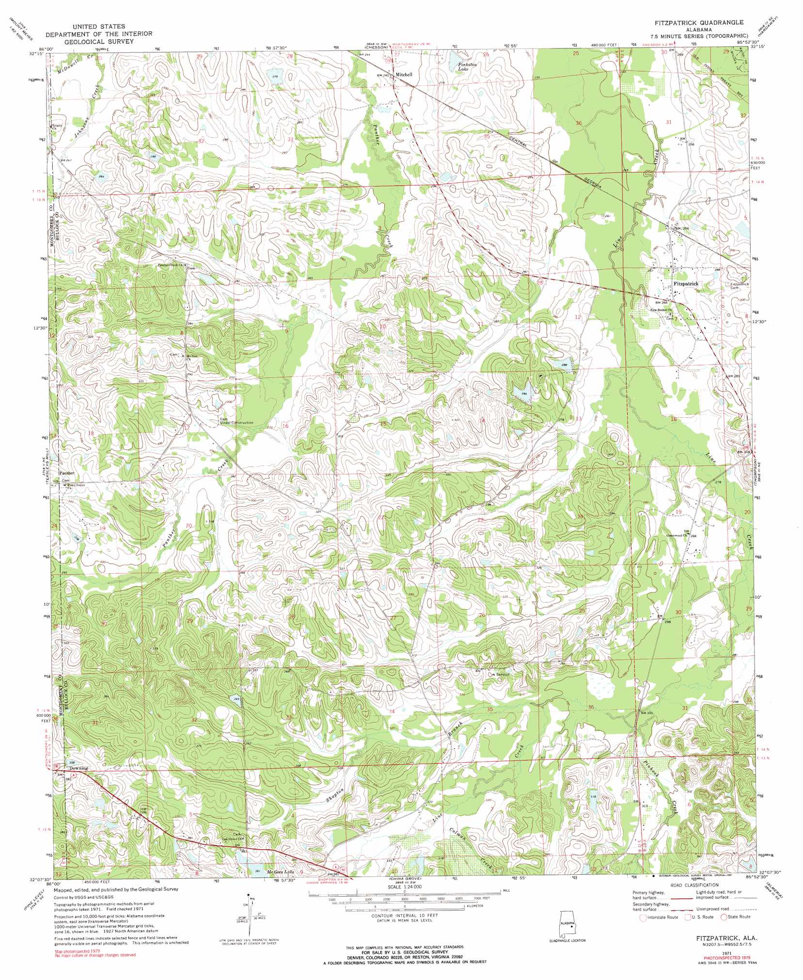
USGS Topo Quad 32085b8 - 1:24,000 scale
| Topo Map Name: | Fitzpatrick |
| USGS Topo Quad ID: | 32085b8 |
| Print Size: | ca. 21 1/4" wide x 27" high |
| Southeast Coordinates: | 32.125° N latitude / 85.875° W longitude |
| Map Center Coordinates: | 32.1875° N latitude / 85.9375° W longitude |
| U.S. State: | AL |
| Filename: | o32085b8.jpg |
| Download Map JPG Image: | Fitzpatrick topo map 1:24,000 scale |
| Map Type: | Topographic |
| Topo Series: | 7.5´ |
| Map Scale: | 1:24,000 |
| Source of Map Images: | United States Geological Survey (USGS) |
| Alternate Map Versions: |
Fitzpatrick AL 1971, updated 1974 Download PDF Buy paper map Fitzpatrick AL 1971, updated 1991 Download PDF Buy paper map Fitzpatrick AL 2011 Download PDF Buy paper map Fitzpatrick AL 2014 Download PDF Buy paper map |
1:24,000 Topo Quads surrounding Fitzpatrick
Willow Springs |
Brassell |
Shorter |
La Place |
Tuskegee |
Barachias |
Mount Meigs |
Chesson |
Hardaway |
Davisville |
Davis Crossroads |
Teasleys Mill |
Fitzpatrick |
Thompson |
Union Springs |
Ramer |
Pine Level |
China Grove |
Almeria |
Aberfoil |
Grady |
Ansley |
Needmore |
Saco |
Perote |
> Back to 32085a1 at 1:100,000 scale
> Back to 32084a1 at 1:250,000 scale
> Back to U.S. Topo Maps home
Fitzpatrick topo map: Gazetteer
Fitzpatrick: Dams
Forrer Number 1 Dam elevation 88m 288′Forrer Number 2 Dam elevation 87m 285′
Mcghee Pond elevation 110m 360′
Mitchell Lake Dam elevation 85m 278′
Rutland Pond Dam elevation 86m 282′
Tompkins Dam elevation 96m 314′
Turnipseed Lake Dam elevation 106m 347′
Fitzpatrick: Populated Places
Fitzpatrick elevation 80m 262′Mitchell elevation 74m 242′
Fitzpatrick: Reservoirs
Lake Forrer Number One elevation 88m 288′Lake Forrer Number Two elevation 87m 285′
McGhee Lake Number Two elevation 110m 360′
Mitchell Lake elevation 85m 278′
Pinkston Lake elevation 79m 259′
Rutland Lake elevation 86m 282′
Tompkins Lake elevation 96m 314′
Turnipseed Lake elevation 106m 347′
Fitzpatrick: Streams
Colman Creek elevation 95m 311′Pinhook Creek elevation 87m 285′
Shopton Branch elevation 91m 298′
Fitzpatrick digital topo map on disk
Buy this Fitzpatrick topo map showing relief, roads, GPS coordinates and other geographical features, as a high-resolution digital map file on DVD:
Gulf Coast (LA, MS, AL, FL) & Southwestern Georgia
Buy digital topo maps: Gulf Coast (LA, MS, AL, FL) & Southwestern Georgia
 & Southwestern Georgia map DVD")