Fort Mitchell Topo Map Alabama
To zoom in, hover over the map of Fort Mitchell
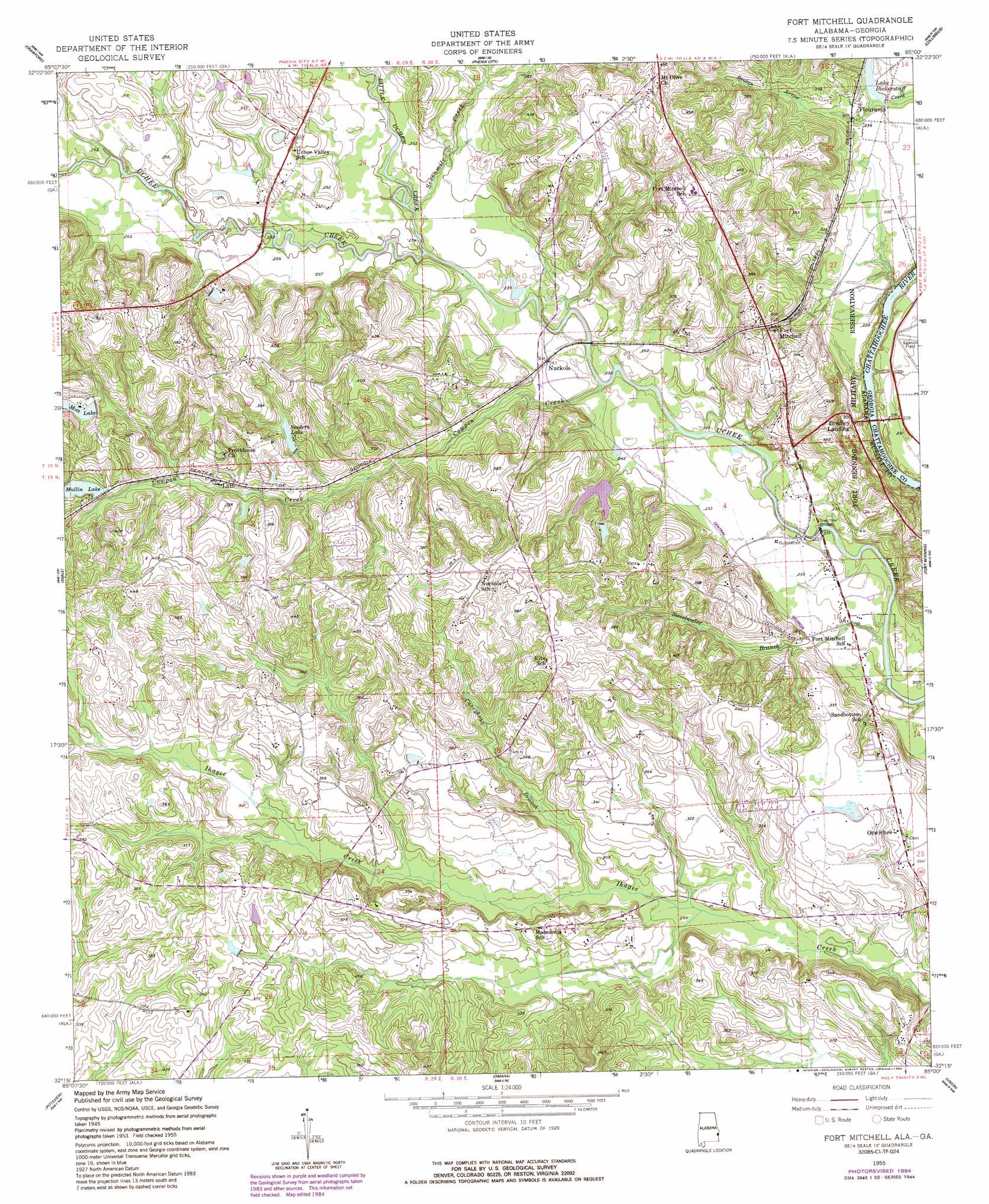
USGS Topo Quad 32085c1 - 1:24,000 scale
| Topo Map Name: | Fort Mitchell |
| USGS Topo Quad ID: | 32085c1 |
| Print Size: | ca. 21 1/4" wide x 27" high |
| Southeast Coordinates: | 32.25° N latitude / 85° W longitude |
| Map Center Coordinates: | 32.3125° N latitude / 85.0625° W longitude |
| U.S. States: | AL, GA |
| Filename: | o32085c1.jpg |
| Download Map JPG Image: | Fort Mitchell topo map 1:24,000 scale |
| Map Type: | Topographic |
| Topo Series: | 7.5´ |
| Map Scale: | 1:24,000 |
| Source of Map Images: | United States Geological Survey (USGS) |
| Alternate Map Versions: |
Fort Mitchell AL 1949 Download PDF Buy paper map Fort Mitchell AL 1955, updated 1959 Download PDF Buy paper map Fort Mitchell AL 1955, updated 1970 Download PDF Buy paper map Fort Mitchell AL 1955, updated 1984 Download PDF Buy paper map Fort Mitchell AL 2011 Download PDF Buy paper map Fort Mitchell AL 2011 Download PDF Buy paper map Fort Mitchell AL 2014 Download PDF Buy paper map |
1:24,000 Topo Quads surrounding Fort Mitchell
Parkers Crossroads |
Bleecker |
Smiths Station |
Fortson |
Midland |
Marvyn |
Crawford |
Phenix City |
Columbus |
Ochillee |
Hatchechubbee |
Seale |
Fort Mitchell |
Fort Benning |
Cusseta |
Rutherford |
Pittsview |
Omaha |
Union |
Louvale |
Batesville |
Howe |
Twin Springs |
Lumpkin Sw |
Lumpkin |
> Back to 32085a1 at 1:100,000 scale
> Back to 32084a1 at 1:250,000 scale
> Back to U.S. Topo Maps home
Fort Mitchell topo map: Gazetteer
Fort Mitchell: Bridges
Eddy Bridge elevation 54m 177′Nuckols Bridge elevation 52m 170′
Oswichee Bridge elevation 63m 206′
Youngs Bridge elevation 77m 252′
Fort Mitchell: Crossings
Perrys Ford (historical) elevation 79m 259′Fort Mitchell: Dams
Mullin Lake Dam elevation 99m 324′Snyder Pond Dam elevation 91m 298′
Yuchi Lake Dam elevation 103m 337′
Fort Mitchell: Populated Places
Flournoys elevation 71m 232′Fort Mitchell elevation 108m 354′
Lato elevation 94m 308′
Nuckols elevation 73m 239′
Oswichee elevation 100m 328′
Fort Mitchell: Post Offices
Uchee Shoals Post Office (historical) elevation 66m 216′Fort Mitchell: Reservoirs
Bradleys Pond elevation 91m 298′Lake Bickerstaff elevation 66m 216′
Mott Lake elevation 103m 337′
Mullin Lake elevation 108m 354′
Sniders Lake elevation 99m 324′
Fort Mitchell: Streams
Caneyhead Branch elevation 81m 265′Cowpen Creek elevation 69m 226′
Little Uchee Creek elevation 72m 236′
Sevenmile Creek elevation 74m 242′
Sweetwater Branch elevation 63m 206′
Fort Mitchell digital topo map on disk
Buy this Fort Mitchell topo map showing relief, roads, GPS coordinates and other geographical features, as a high-resolution digital map file on DVD:
Gulf Coast (LA, MS, AL, FL) & Southwestern Georgia
Buy digital topo maps: Gulf Coast (LA, MS, AL, FL) & Southwestern Georgia
 & Southwestern Georgia map DVD")