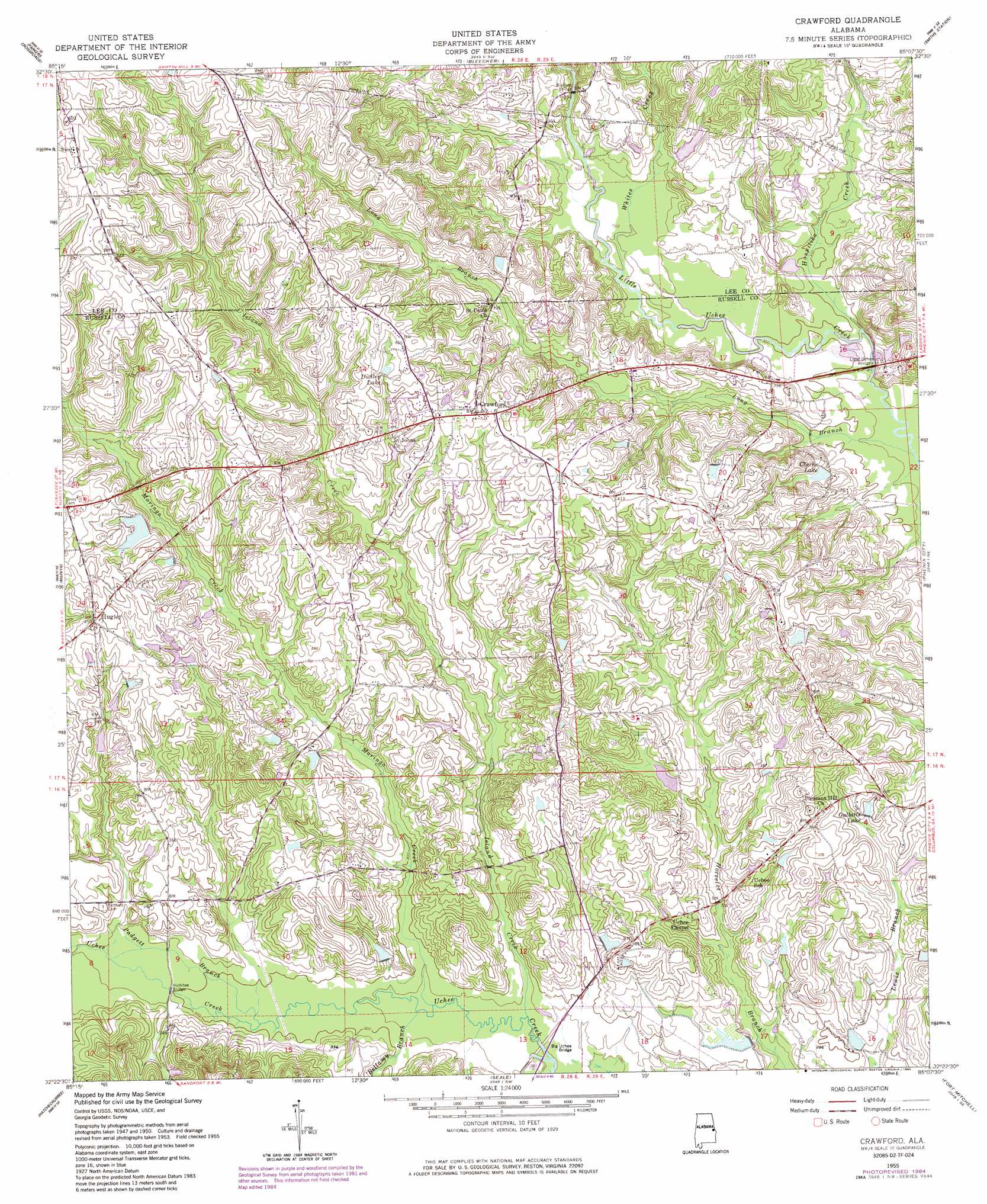
Crawford Topo Map Alabama
To zoom in, hover over the map of Crawford
USGS Topo Quad 32085d2 - 1:24,000 scale
| Topo Map Name: | Crawford |
| USGS Topo Quad ID: | 32085d2 |
| Print Size: | ca. 21 1/4" wide x 27" high |
| Southeast Coordinates: | 32.375° N latitude / 85.125° W longitude |
| Map Center Coordinates: | 32.4375° N latitude / 85.1875° W longitude |
| U.S. State: | AL |
| Filename: | o32085d2.jpg |
| Download Map JPG Image: | Crawford topo map 1:24,000 scale |
| Map Type: | Topographic |
| Topo Series: | 7.5´ |
| Map Scale: | 1:24,000 |
| Source of Map Images: | United States Geological Survey (USGS) |
| Alternate Map Versions: |
Crawford AL 1950, updated 1953 Download PDF Buy paper map Crawford AL 1955, updated 1959 Download PDF Buy paper map Crawford AL 1955, updated 1970 Download PDF Buy paper map Crawford AL 1955, updated 1984 Download PDF Buy paper map Crawford AL 2011 Download PDF Buy paper map Crawford AL 2014 Download PDF Buy paper map |
1:24,000 Topo Quads surrounding Crawford
Opelika West |
Opelika East |
Beulah |
Bartletts Ferry Dam |
Mulberry Grove |
Auburn |
Parkers Crossroads |
Bleecker |
Smiths Station |
Fortson |
Society Hill |
Marvyn |
Crawford |
Phenix City |
Columbus |
Creek Stand |
Hatchechubbee |
Seale |
Fort Mitchell |
Fort Benning |
Hurtsboro |
Rutherford |
Pittsview |
Omaha |
Union |
> Back to 32085a1 at 1:100,000 scale
> Back to 32084a1 at 1:250,000 scale
> Back to U.S. Topo Maps home
Crawford topo map: Gazetteer
Crawford: Bridges
Bishops Bridge elevation 107m 351′Hichitee Bridge elevation 91m 298′
Little Uchee Bridge elevation 91m 298′
Crawford: Dams
Crouch Pond Dam elevation 96m 314′Heath Dam elevation 104m 341′
Parkman Pond Dam elevation 93m 305′
Williams Lake Dam elevation 120m 393′
Crawford: Populated Places
Crawford elevation 136m 446′Hugley elevation 138m 452′
Parkmanville elevation 100m 328′
Crawford: Reservoirs
Browns Pond elevation 107m 351′Clarks Lake elevation 97m 318′
Dudley Lake elevation 135m 442′
Fullers Pond elevation 122m 400′
Gullatts Lake elevation 104m 341′
Heath Lake elevation 104m 341′
Hugleys Pond elevation 110m 360′
Kites Pond elevation 111m 364′
Lydells Pond elevation 119m 390′
Parkmans Pond elevation 85m 278′
Parrs Pond elevation 97m 318′
Smiths Pond elevation 94m 308′
Wheeless Pond elevation 87m 285′
Williams Lake elevation 129m 423′
Crawford: Streams
Adams Branch elevation 94m 308′Bellamy Branch elevation 87m 285′
Hospilika Creek elevation 92m 301′
Island Creek elevation 86m 282′
Long Branch elevation 87m 285′
Maringo Creek elevation 87m 285′
Padgett Branch elevation 90m 295′
Whites Creek elevation 94m 308′
Crawford digital topo map on disk
Buy this Crawford topo map showing relief, roads, GPS coordinates and other geographical features, as a high-resolution digital map file on DVD:
Gulf Coast (LA, MS, AL, FL) & Southwestern Georgia
Buy digital topo maps: Gulf Coast (LA, MS, AL, FL) & Southwestern Georgia
 & Southwestern Georgia map DVD")