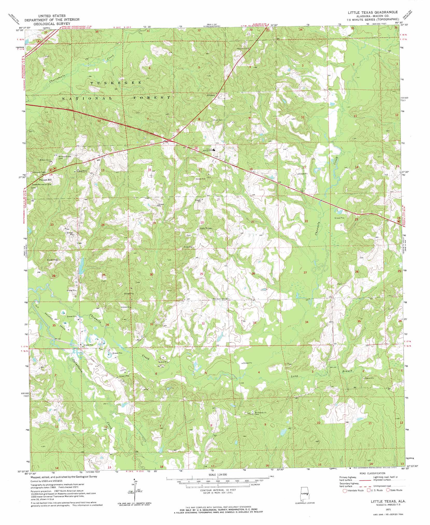
Little Texas Topo Map Alabama
To zoom in, hover over the map of Little Texas
USGS Topo Quad 32085d5 - 1:24,000 scale
| Topo Map Name: | Little Texas |
| USGS Topo Quad ID: | 32085d5 |
| Print Size: | ca. 21 1/4" wide x 27" high |
| Southeast Coordinates: | 32.375° N latitude / 85.5° W longitude |
| Map Center Coordinates: | 32.4375° N latitude / 85.5625° W longitude |
| U.S. State: | AL |
| Filename: | o32085d5.jpg |
| Download Map JPG Image: | Little Texas topo map 1:24,000 scale |
| Map Type: | Topographic |
| Topo Series: | 7.5´ |
| Map Scale: | 1:24,000 |
| Source of Map Images: | United States Geological Survey (USGS) |
| Alternate Map Versions: |
Little Texas AL 1971, updated 1973 Download PDF Buy paper map Little Texas AL 1971, updated 1973 Download PDF Buy paper map Little Texas AL 1998, updated 2001 Download PDF Buy paper map Little Texas AL 2011 Download PDF Buy paper map Little Texas AL 2014 Download PDF Buy paper map |
| FStopo: | US Forest Service topo Little Texas is available: Download FStopo PDF Download FStopo TIF |
1:24,000 Topo Quads surrounding Little Texas
Ponders |
Thornton |
Waverly |
Opelika West |
Opelika East |
Carrville |
Notasulga |
Loachapoka |
Auburn |
Parkers Crossroads |
La Place |
Tuskegee |
Little Texas |
Society Hill |
Marvyn |
Hardaway |
Davisville |
Warriorstand |
Creek Stand |
Hatchechubbee |
Thompson |
Union Springs |
Roba |
Hurtsboro |
Rutherford |
> Back to 32085a1 at 1:100,000 scale
> Back to 32084a1 at 1:250,000 scale
> Back to U.S. Topo Maps home
Little Texas topo map: Gazetteer
Little Texas: Forests
Tuskegee National Forest elevation 95m 311′Little Texas: Populated Places
Alliance elevation 162m 531′Little Texas elevation 163m 534′
Pleasant Hill elevation 143m 469′
Little Texas: Streams
Big Branch elevation 101m 331′Camp Ground Branch elevation 87m 285′
Chewacla Creek elevation 80m 262′
Cossey Branch elevation 107m 351′
Gilmore Branch elevation 103m 337′
Hodnett Creek elevation 91m 298′
Long Branch elevation 93m 305′
Miles Creek elevation 84m 275′
Opintlocco Creek elevation 80m 262′
Little Texas digital topo map on disk
Buy this Little Texas topo map showing relief, roads, GPS coordinates and other geographical features, as a high-resolution digital map file on DVD:
Gulf Coast (LA, MS, AL, FL) & Southwestern Georgia
Buy digital topo maps: Gulf Coast (LA, MS, AL, FL) & Southwestern Georgia
 & Southwestern Georgia map DVD")