Tallassee Topo Map Alabama
To zoom in, hover over the map of Tallassee
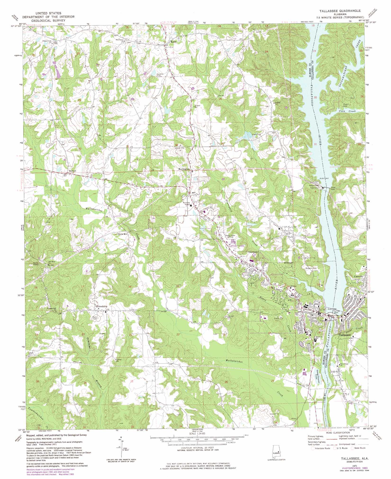
USGS Topo Quad 32085e8 - 1:24,000 scale
| Topo Map Name: | Tallassee |
| USGS Topo Quad ID: | 32085e8 |
| Print Size: | ca. 21 1/4" wide x 27" high |
| Southeast Coordinates: | 32.5° N latitude / 85.875° W longitude |
| Map Center Coordinates: | 32.5625° N latitude / 85.9375° W longitude |
| U.S. State: | AL |
| Filename: | o32085e8.jpg |
| Download Map JPG Image: | Tallassee topo map 1:24,000 scale |
| Map Type: | Topographic |
| Topo Series: | 7.5´ |
| Map Scale: | 1:24,000 |
| Source of Map Images: | United States Geological Survey (USGS) |
| Alternate Map Versions: |
Tallassee AL 1971, updated 1973 Download PDF Buy paper map Tallassee AL 1971, updated 1984 Download PDF Buy paper map Tallassee AL 2011 Download PDF Buy paper map Tallassee AL 2014 Download PDF Buy paper map |
1:24,000 Topo Quads surrounding Tallassee
Rockford Sw |
Equality |
Our Town |
Dadeville |
Camp Hill |
Dexter |
Eclectic |
Red Hill |
Ponders |
Thornton |
Wetumpka |
Claud |
Tallassee |
Carrville |
Notasulga |
Willow Springs |
Brassell |
Shorter |
La Place |
Tuskegee |
Barachias |
Mount Meigs |
Chesson |
Hardaway |
Davisville |
> Back to 32085e1 at 1:100,000 scale
> Back to 32084a1 at 1:250,000 scale
> Back to U.S. Topo Maps home
Tallassee topo map: Gazetteer
Tallassee: Dams
Annie T Gregory Lake Dam elevation 141m 462′Tallassee Sewage Disposal Pond Dam elevation 70m 229′
Thurlow Dam elevation 88m 288′
Yates Dam elevation 104m 341′
Tallassee: Falls
Tallapoosa Falls (historical) elevation 88m 288′Tallassee: Parks
Tallassee Commercial Historic District elevation 117m 383′Tallassee: Populated Places
Burlington elevation 169m 554′Butts Mill elevation 102m 334′
Chana Creek elevation 165m 541′
Friendship elevation 148m 485′
Hornsbytown elevation 131m 429′
Jordanville elevation 118m 387′
Kent elevation 177m 580′
Liberty elevation 127m 416′
Neman elevation 110m 360′
Tallassee elevation 119m 390′
Tallassee: Post Offices
East Tallassee Post Office elevation 97m 318′Omar Post Office (historical) elevation 136m 446′
Tallassee: Reservoirs
Annie T Gregory Lake elevation 141m 462′Tallassee Sewage Disposal Pond elevation 70m 229′
Thurlow Reservoir elevation 67m 219′
Yates Reservoir elevation 142m 465′
Tallassee: Streams
Coon Creek elevation 104m 341′Graveyard Creek elevation 88m 288′
Harrington Branch elevation 85m 278′
Lewis Creek elevation 59m 193′
Sougahatchee Creek elevation 104m 341′
Stone Creek elevation 59m 193′
Tallassee digital topo map on disk
Buy this Tallassee topo map showing relief, roads, GPS coordinates and other geographical features, as a high-resolution digital map file on DVD:
Gulf Coast (LA, MS, AL, FL) & Southwestern Georgia
Buy digital topo maps: Gulf Coast (LA, MS, AL, FL) & Southwestern Georgia
 & Southwestern Georgia map DVD")