Red Hill Topo Map Alabama
To zoom in, hover over the map of Red Hill
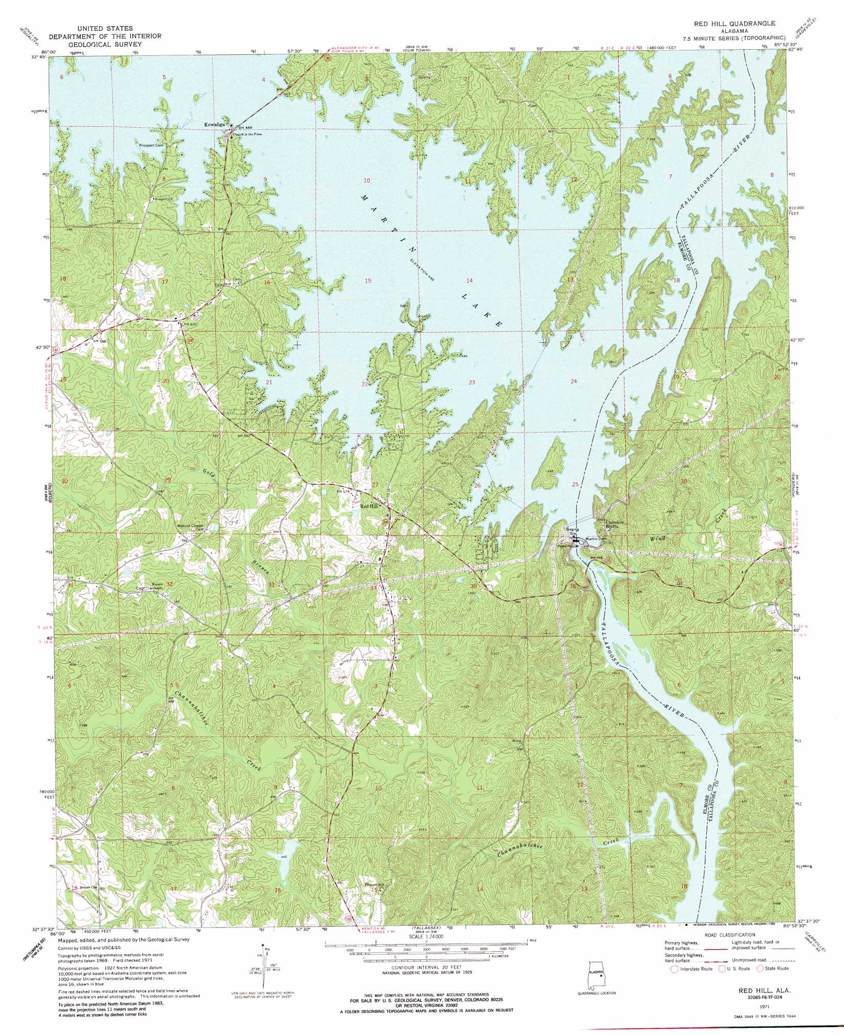
USGS Topo Quad 32085f8 - 1:24,000 scale
| Topo Map Name: | Red Hill |
| USGS Topo Quad ID: | 32085f8 |
| Print Size: | ca. 21 1/4" wide x 27" high |
| Southeast Coordinates: | 32.625° N latitude / 85.875° W longitude |
| Map Center Coordinates: | 32.6875° N latitude / 85.9375° W longitude |
| U.S. State: | AL |
| Filename: | o32085f8.jpg |
| Download Map JPG Image: | Red Hill topo map 1:24,000 scale |
| Map Type: | Topographic |
| Topo Series: | 7.5´ |
| Map Scale: | 1:24,000 |
| Source of Map Images: | United States Geological Survey (USGS) |
| Alternate Map Versions: |
Red Hill AL 1971, updated 1973 Download PDF Buy paper map Red Hill AL 1971, updated 1986 Download PDF Buy paper map Red Hill AL 2011 Download PDF Buy paper map Red Hill AL 2014 Download PDF Buy paper map |
1:24,000 Topo Quads surrounding Red Hill
Rockford |
Kellyton |
Alexander City |
Jacksons Gap |
Buttston |
Rockford Sw |
Equality |
Our Town |
Dadeville |
Camp Hill |
Dexter |
Eclectic |
Red Hill |
Ponders |
Thornton |
Wetumpka |
Claud |
Tallassee |
Carrville |
Notasulga |
Willow Springs |
Brassell |
Shorter |
La Place |
Tuskegee |
> Back to 32085e1 at 1:100,000 scale
> Back to 32084a1 at 1:250,000 scale
> Back to U.S. Topo Maps home
Red Hill topo map: Gazetteer
Red Hill: Capes
Rocky Point elevation 153m 501′Red Hill: Crossings
Double Bridges Ferry (historical) elevation 104m 341′McCarty Ferry (historical) elevation 149m 488′
Red Hill: Dams
Martin Dam elevation 129m 423′Red Hill: Populated Places
Cherokee Bluffs elevation 171m 561′Kowaliga elevation 153m 501′
Red Hill elevation 184m 603′
Red Hill: Reservoirs
Martin Lake elevation 133m 436′Red Hill: Streams
Channahatchee Creek elevation 104m 341′Gold Branch elevation 120m 393′
Wind Creek elevation 104m 341′
Red Hill digital topo map on disk
Buy this Red Hill topo map showing relief, roads, GPS coordinates and other geographical features, as a high-resolution digital map file on DVD:
Gulf Coast (LA, MS, AL, FL) & Southwestern Georgia
Buy digital topo maps: Gulf Coast (LA, MS, AL, FL) & Southwestern Georgia
 & Southwestern Georgia map DVD")