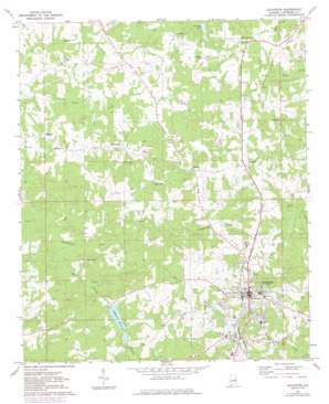
Lafayette Topo Map Alabama
To zoom in, hover over the map of Lafayette
USGS Topo Quad 32085h4 - 1:24,000 scale
| Topo Map Name: | Lafayette |
| USGS Topo Quad ID: | 32085h4 |
| Print Size: | ca. 21 1/4" wide x 27" high |
| Southeast Coordinates: | 32.875° N latitude / 85.375° W longitude |
| Map Center Coordinates: | 32.9375° N latitude / 85.4375° W longitude |
| U.S. State: | AL |
| Filename: | o32085h4.jpg |
| Download Map JPG Image: | Lafayette topo map 1:24,000 scale |
| Map Type: | Topographic |
| Topo Series: | 7.5´ |
| Map Scale: | 1:24,000 |
| Source of Map Images: | United States Geological Survey (USGS) |
| Alternate Map Versions: |
Lafayette AL 1971, updated 1973 Download PDF Buy paper map Lafayette AL 1971, updated 1984 Download PDF Buy paper map Lafayette AL 2011 Download PDF Buy paper map Lafayette AL 2014 Download PDF Buy paper map |
1:24,000 Topo Quads surrounding Lafayette
> Back to 32085e1 at 1:100,000 scale
> Back to 32084a1 at 1:250,000 scale
> Back to U.S. Topo Maps home
Lafayette topo map: Gazetteer
Lafayette: Dams
Lafayette City Lake Dam elevation 204m 669′Nolen Dam elevation 251m 823′
Robinson Dam elevation 233m 764′
Sharpe Number 1 Dam elevation 229m 751′
Sharpe Number 2 Dam elevation 237m 777′
Slay Dam elevation 245m 803′
W C Hines Dam elevation 231m 757′
Wheeler Dam elevation 228m 748′
Lafayette: Parks
Lafayette City Park elevation 238m 780′Lafayette: Populated Places
Buffalo elevation 262m 859′Chapel Hill elevation 257m 843′
Lafayette elevation 257m 843′
Marcoot elevation 238m 780′
Rollins elevation 257m 843′
White Plains elevation 264m 866′
Lafayette: Post Offices
Lafayette Post Office elevation 256m 839′Lafayette: Reservoirs
Lafayette Reservoir elevation 204m 669′Nolen Lake elevation 251m 823′
Robinson Lake elevation 233m 764′
Sharpe Lake Number 2 elevation 237m 777′
Sharpe Number One Lake elevation 229m 751′
Sharpes Lake elevation 228m 748′
Slay Lake elevation 245m 803′
W C Hines Lake elevation 231m 757′
Wheeler Lake elevation 228m 748′
Lafayette: Springs
Little Sulfer Springs elevation 237m 777′Murry Springs elevation 207m 679′
Lafayette: Streams
Finley Creek elevation 196m 643′Landrum Creek elevation 212m 695′
Mill Creek elevation 193m 633′
Lafayette digital topo map on disk
Buy this Lafayette topo map showing relief, roads, GPS coordinates and other geographical features, as a high-resolution digital map file on DVD:
Gulf Coast (LA, MS, AL, FL) & Southwestern Georgia
Buy digital topo maps: Gulf Coast (LA, MS, AL, FL) & Southwestern Georgia


