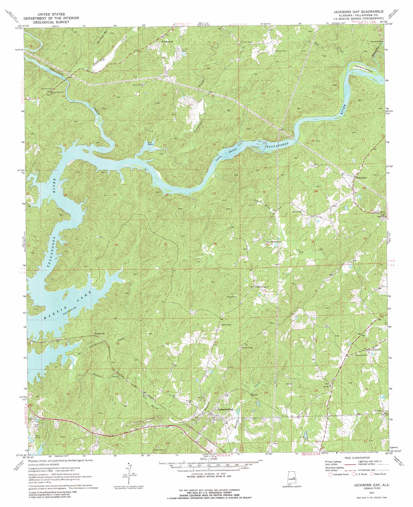
Jacksons Gap Topo Map Alabama
To zoom in, hover over the map of Jacksons Gap
USGS Topo Quad 32085h7 - 1:24,000 scale
| Topo Map Name: | Jacksons Gap |
| USGS Topo Quad ID: | 32085h7 |
| Print Size: | ca. 21 1/4" wide x 27" high |
| Southeast Coordinates: | 32.875° N latitude / 85.75° W longitude |
| Map Center Coordinates: | 32.9375° N latitude / 85.8125° W longitude |
| U.S. State: | AL |
| Filename: | o32085h7.jpg |
| Download Map JPG Image: | Jacksons Gap topo map 1:24,000 scale |
| Map Type: | Topographic |
| Topo Series: | 7.5´ |
| Map Scale: | 1:24,000 |
| Source of Map Images: | United States Geological Survey (USGS) |
| Alternate Map Versions: |
Jacksons Gap AL 1971, updated 1974 Download PDF Buy paper map Jacksons Gap AL 1971, updated 1989 Download PDF Buy paper map Jacksons Gap AL 2011 Download PDF Buy paper map Jacksons Gap AL 2014 Download PDF Buy paper map |
1:24,000 Topo Quads surrounding Jacksons Gap
Bulls Gap |
Millerville |
Gibsonville |
Mellow Valley |
Wadley North |
Goodwater |
Hackneyville |
New Site |
Daviston |
Wadley South |
Kellyton |
Alexander City |
Jacksons Gap |
Buttston |
Dudleyville |
Equality |
Our Town |
Dadeville |
Camp Hill |
Camp Hill Se |
Eclectic |
Red Hill |
Ponders |
Thornton |
Waverly |
> Back to 32085e1 at 1:100,000 scale
> Back to 32084a1 at 1:250,000 scale
> Back to U.S. Topo Maps home
Jacksons Gap topo map: Gazetteer
Jacksons Gap: Bars
Irwin Shoals elevation 149m 488′Jacksons Gap: Channels
Hams Cut elevation 214m 702′Jacksons Gap: Crossings
Stow Ferry (historical) elevation 149m 488′Welch Ferry (historical) elevation 149m 488′
Whaley Ferry (historical) elevation 154m 505′
Jacksons Gap: Islands
Peters Island elevation 166m 544′Jacksons Gap: Populated Places
Eagle Creek elevation 235m 770′Fosheeton elevation 226m 741′
Jacksons Gap elevation 195m 639′
Midway elevation 187m 613′
Sturdivant elevation 178m 583′
Tohopeka elevation 214m 702′
Jacksons Gap: Post Offices
Jacksons Gap Post Office elevation 195m 639′Jacksons Gap: Streams
Coley Creek elevation 149m 488′Emuckfaw Creek elevation 159m 521′
Fox Creek elevation 157m 515′
Gin House Branch elevation 151m 495′
Hillabee Creek elevation 149m 488′
Jay Bird Creek elevation 149m 488′
Josie Leg Creek elevation 152m 498′
Sturdivant Creek elevation 149m 488′
Timbergut Creek elevation 152m 498′
Turkey Branch elevation 162m 531′
Jacksons Gap digital topo map on disk
Buy this Jacksons Gap topo map showing relief, roads, GPS coordinates and other geographical features, as a high-resolution digital map file on DVD:
Gulf Coast (LA, MS, AL, FL) & Southwestern Georgia
Buy digital topo maps: Gulf Coast (LA, MS, AL, FL) & Southwestern Georgia
 & Southwestern Georgia map DVD")