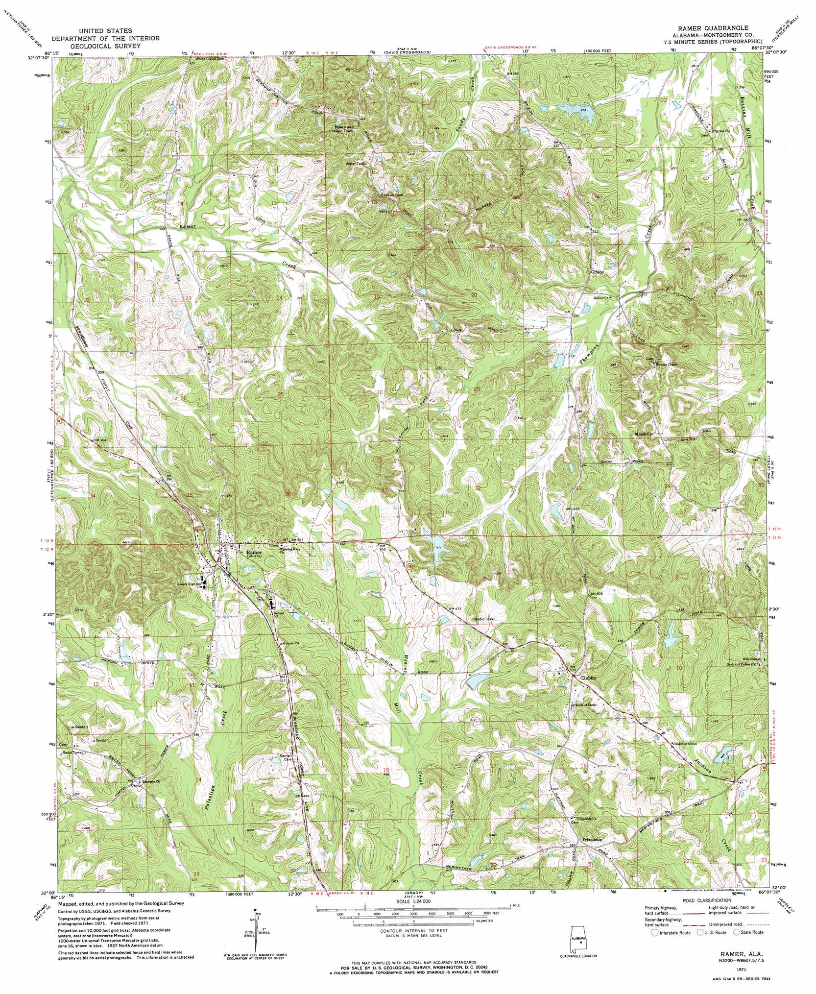
Ramer Topo Map Alabama
To zoom in, hover over the map of Ramer
USGS Topo Quad 32086a2 - 1:24,000 scale
| Topo Map Name: | Ramer |
| USGS Topo Quad ID: | 32086a2 |
| Print Size: | ca. 21 1/4" wide x 27" high |
| Southeast Coordinates: | 32° N latitude / 86.125° W longitude |
| Map Center Coordinates: | 32.0625° N latitude / 86.1875° W longitude |
| U.S. State: | AL |
| Filename: | o32086a2.jpg |
| Download Map JPG Image: | Ramer topo map 1:24,000 scale |
| Map Type: | Topographic |
| Topo Series: | 7.5´ |
| Map Scale: | 1:24,000 |
| Source of Map Images: | United States Geological Survey (USGS) |
| Alternate Map Versions: |
Ramer AL 1971, updated 1974 Download PDF Buy paper map Ramer AL 1971, updated 1974 Download PDF Buy paper map Ramer AL 2011 Download PDF Buy paper map Ramer AL 2014 Download PDF Buy paper map |
1:24,000 Topo Quads surrounding Ramer
Cantelous |
Montgomery South |
Barachias |
Mount Meigs |
Chesson |
Letohatchee |
Snowdoun |
Davis Crossroads |
Teasleys Mill |
Fitzpatrick |
Sandy Ridge |
Sellers |
Ramer |
Pine Level |
China Grove |
Danielsville |
Lapine |
Grady |
Ansley |
Needmore |
Honoraville |
Fullers Crossroads |
Petrey |
Youngblood |
Troy |
> Back to 32086a1 at 1:100,000 scale
> Back to 32086a1 at 1:250,000 scale
> Back to U.S. Topo Maps home
Ramer topo map: Gazetteer
Ramer: Dams
Bob Thompson Dam elevation 96m 314′C E Neal Dam elevation 133m 436′
C E Sellers Dam elevation 118m 387′
Evans Dam elevation 97m 318′
Fannin Dam elevation 153m 501′
Morris Dees Dam elevation 110m 360′
Strickland Dam elevation 143m 469′
Ramer: Populated Places
Dublin elevation 165m 541′Friendship elevation 155m 508′
Gibson elevation 102m 334′
Meadville elevation 128m 419′
Ramer elevation 143m 469′
Ramer: Post Offices
Ramer Post Office elevation 130m 426′Ramer: Reservoirs
Bob Thompson Lake elevation 96m 314′C E Sellers Lake elevation 118m 387′
Dees Lake elevation 110m 360′
Evans Lake elevation 98m 321′
Evans Lake elevation 97m 318′
Neal Lake elevation 133m 436′
Rushing Lake elevation 153m 501′
Strickland Lake elevation 143m 469′
Ramer digital topo map on disk
Buy this Ramer topo map showing relief, roads, GPS coordinates and other geographical features, as a high-resolution digital map file on DVD:
Gulf Coast (LA, MS, AL, FL) & Southwestern Georgia
Buy digital topo maps: Gulf Coast (LA, MS, AL, FL) & Southwestern Georgia
 & Southwestern Georgia map DVD")