Letohatchee Topo Map Alabama
To zoom in, hover over the map of Letohatchee
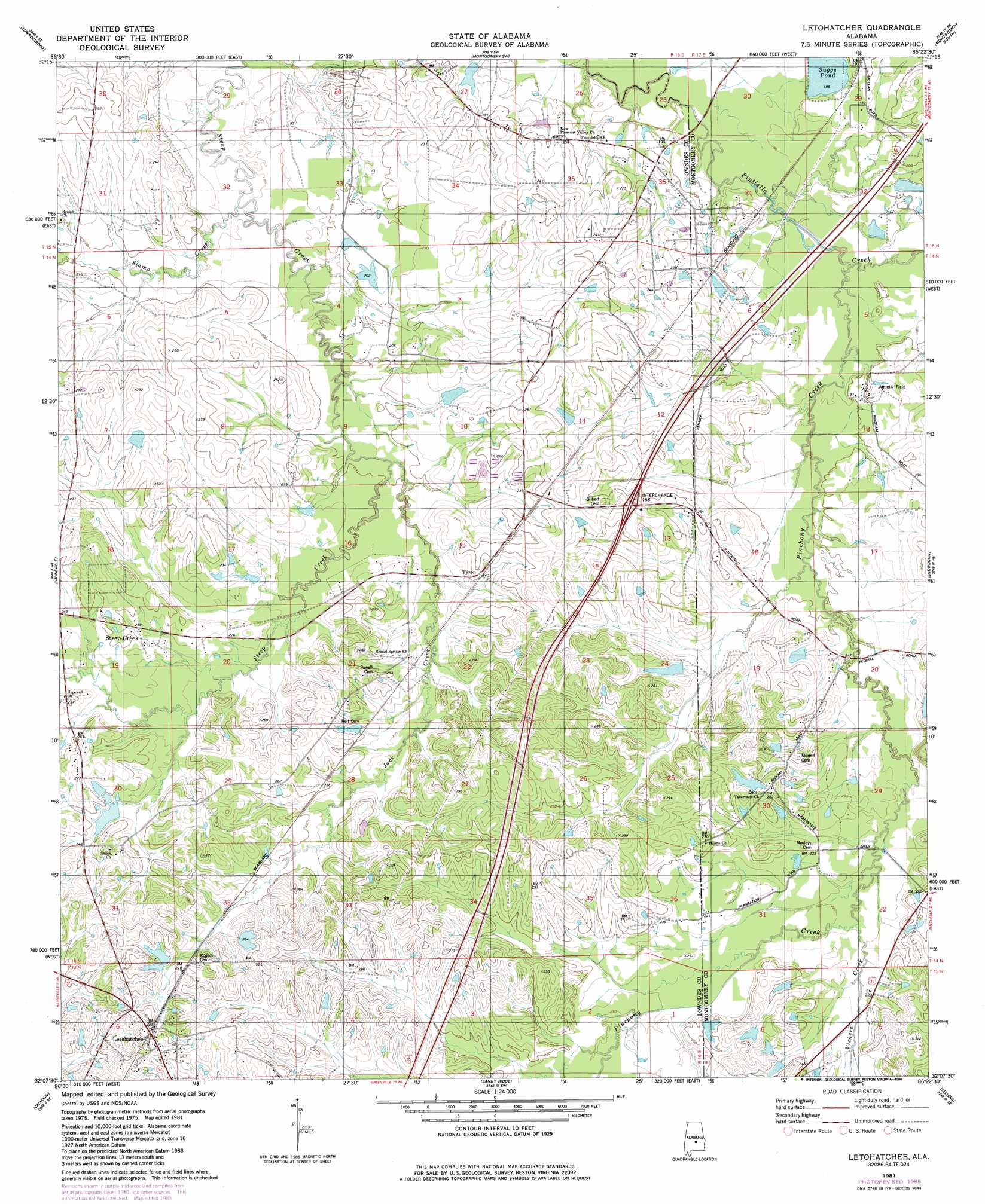
USGS Topo Quad 32086b4 - 1:24,000 scale
| Topo Map Name: | Letohatchee |
| USGS Topo Quad ID: | 32086b4 |
| Print Size: | ca. 21 1/4" wide x 27" high |
| Southeast Coordinates: | 32.125° N latitude / 86.375° W longitude |
| Map Center Coordinates: | 32.1875° N latitude / 86.4375° W longitude |
| U.S. State: | AL |
| Filename: | o32086b4.jpg |
| Download Map JPG Image: | Letohatchee topo map 1:24,000 scale |
| Map Type: | Topographic |
| Topo Series: | 7.5´ |
| Map Scale: | 1:24,000 |
| Source of Map Images: | United States Geological Survey (USGS) |
| Alternate Map Versions: |
Letohatchee AL 1981, updated 1981 Download PDF Buy paper map Letohatchee AL 1981, updated 1986 Download PDF Buy paper map Letohatchee AL 2011 Download PDF Buy paper map Letohatchee AL 2014 Download PDF Buy paper map |
1:24,000 Topo Quads surrounding Letohatchee
Autaugaville |
Forester |
Prattville |
Montgomery North |
Willow Springs |
White Hall |
Lowndesboro |
Cantelous |
Montgomery South |
Barachias |
Gordonsville |
Hayneville |
Letohatchee |
Snowdoun |
Davis Crossroads |
Mount Willing |
Calhoun |
Sandy Ridge |
Sellers |
Ramer |
Fort Dale |
Fort Deposit |
Danielsville |
Lapine |
Grady |
> Back to 32086a1 at 1:100,000 scale
> Back to 32086a1 at 1:250,000 scale
> Back to U.S. Topo Maps home
Letohatchee topo map: Gazetteer
Letohatchee: Crossings
Interchange 158 elevation 79m 259′Letohatchee: Dams
C P Crenshaw Dam elevation 86m 282′J L Crenshaw Number 1 Dam elevation 82m 269′
Johnstons Lake Dam elevation 75m 246′
Lila Rebecca Webster Lake Dam elevation 61m 200′
Robert Pinkston Junior Lake Dam elevation 64m 209′
Rogers Dam elevation 76m 249′
Suggs Dam elevation 56m 183′
Wallock Dam elevation 64m 209′
Letohatchee: Populated Places
Letohatchee elevation 98m 321′Rolling Acres elevation 67m 219′
Steep Creek elevation 92m 301′
Tyson elevation 74m 242′
Letohatchee: Post Offices
Letohatchee Post Office elevation 93m 305′Letohatchee: Reservoirs
Crenshaw Ponds elevation 84m 275′Crenshaws Pond elevation 83m 272′
Huffmans Pond elevation 76m 249′
J L Crenshaw Lake Number One elevation 82m 269′
Johnstons Lake elevation 75m 246′
Judges Pond elevation 64m 209′
Lake Wallock elevation 64m 209′
Lila Rebecca Webster Lake elevation 61m 200′
Robert Pinkston Junior Lake elevation 64m 209′
Rogers Pond elevation 76m 249′
Silvests Pond elevation 70m 229′
Suggs Pond elevation 54m 177′
Letohatchee: Streams
Jack Creek elevation 57m 187′North Prong Steep Creek elevation 57m 187′
Pinchony Creek elevation 52m 170′
Vickers Creek elevation 64m 209′
Letohatchee digital topo map on disk
Buy this Letohatchee topo map showing relief, roads, GPS coordinates and other geographical features, as a high-resolution digital map file on DVD:
Gulf Coast (LA, MS, AL, FL) & Southwestern Georgia
Buy digital topo maps: Gulf Coast (LA, MS, AL, FL) & Southwestern Georgia
 & Southwestern Georgia map DVD")