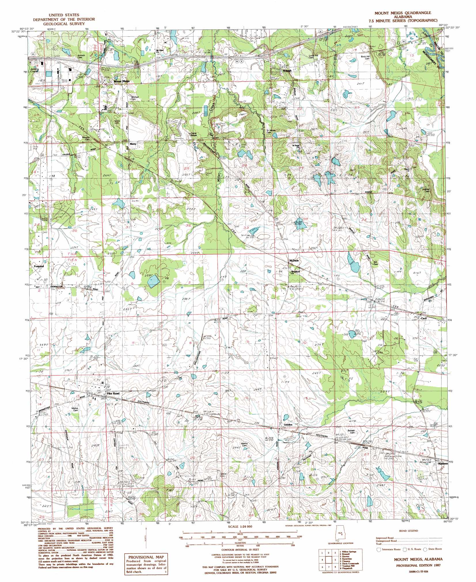
Mount Meigs Topo Map Alabama
To zoom in, hover over the map of Mount Meigs
USGS Topo Quad 32086c1 - 1:24,000 scale
| Topo Map Name: | Mount Meigs |
| USGS Topo Quad ID: | 32086c1 |
| Print Size: | ca. 21 1/4" wide x 27" high |
| Southeast Coordinates: | 32.25° N latitude / 86° W longitude |
| Map Center Coordinates: | 32.3125° N latitude / 86.0625° W longitude |
| U.S. State: | AL |
| Filename: | o32086c1.jpg |
| Download Map JPG Image: | Mount Meigs topo map 1:24,000 scale |
| Map Type: | Topographic |
| Topo Series: | 7.5´ |
| Map Scale: | 1:24,000 |
| Source of Map Images: | United States Geological Survey (USGS) |
| Alternate Map Versions: |
Mount Meigs SE AL 1975, updated 1977 Download PDF Buy paper map Mount Meigs AL 1987, updated 1987 Download PDF Buy paper map Mount Meigs AL 2012 Download PDF Buy paper map Mount Meigs AL 2014 Download PDF Buy paper map |
1:24,000 Topo Quads surrounding Mount Meigs
Elmore |
Wetumpka |
Claud |
Tallassee |
Carrville |
Montgomery North |
Willow Springs |
Brassell |
Shorter |
La Place |
Montgomery South |
Barachias |
Mount Meigs |
Chesson |
Hardaway |
Snowdoun |
Davis Crossroads |
Teasleys Mill |
Fitzpatrick |
Thompson |
Sellers |
Ramer |
Pine Level |
China Grove |
Almeria |
> Back to 32086a1 at 1:100,000 scale
> Back to 32086a1 at 1:250,000 scale
> Back to U.S. Topo Maps home
Mount Meigs topo map: Gazetteer
Mount Meigs: Airports
Kershaw Airport elevation 63m 206′Mount Meigs: Crossings
Interchange 16 elevation 70m 229′Mount Meigs: Dams
Barkley Dam elevation 76m 249′Belser Dam elevation 66m 216′
Boykin Dam elevation 77m 252′
Frank Rutland Number 1 Dam elevation 81m 265′
Frank Rutland Number 2 Dam elevation 71m 232′
Freeman Dam elevation 80m 262′
Gerald Wallace Number 1 Dam elevation 70m 229′
Gerald Wallace Number 2 Dam elevation 66m 216′
McClurkin Number 2 Dam elevation 68m 223′
McClurkin Number 3 Dam elevation 73m 239′
Shirley Dam elevation 89m 291′
Mount Meigs: Populated Places
Cecil elevation 73m 239′Eastwood Villa elevation 62m 203′
Foxchase elevation 73m 239′
Foxwood Trace elevation 81m 265′
Freeport elevation 67m 219′
Knollwood elevation 65m 213′
London elevation 83m 272′
Matthews elevation 77m 252′
McDade elevation 76m 249′
Merry elevation 83m 272′
Mount Meigs elevation 78m 255′
Pike Road elevation 90m 295′
Timberlane elevation 79m 259′
Waugh elevation 82m 269′
Mount Meigs: Post Offices
Mathews Post Office elevation 79m 259′Mount Meigs Post Office elevation 79m 259′
Pike Road Post Office elevation 86m 282′
Mount Meigs: Reservoirs
Barkley Lake elevation 76m 249′Belser Lake elevation 66m 216′
Boykin Lake elevation 77m 252′
Frank Rutland Lake Number 1 elevation 81m 265′
Frank Rutland Lake Number Two elevation 71m 232′
Freeman Lake elevation 80m 262′
Gerald Wallace Lake Number One elevation 70m 229′
Gerald Wallace Lake Number Two elevation 66m 216′
McClurkin Lake Number Three elevation 73m 239′
McClurkin Lake Number Two elevation 68m 223′
Shirley Lake elevation 89m 291′
Mount Meigs digital topo map on disk
Buy this Mount Meigs topo map showing relief, roads, GPS coordinates and other geographical features, as a high-resolution digital map file on DVD:
Gulf Coast (LA, MS, AL, FL) & Southwestern Georgia
Buy digital topo maps: Gulf Coast (LA, MS, AL, FL) & Southwestern Georgia
 & Southwestern Georgia map DVD")