Sardis Topo Map Alabama
To zoom in, hover over the map of Sardis
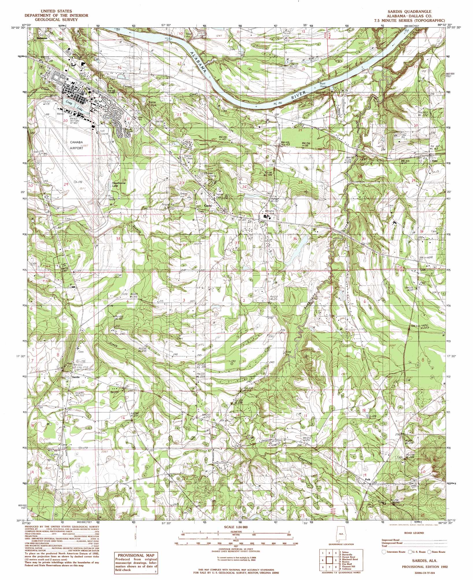
USGS Topo Quad 32086c8 - 1:24,000 scale
| Topo Map Name: | Sardis |
| USGS Topo Quad ID: | 32086c8 |
| Print Size: | ca. 21 1/4" wide x 27" high |
| Southeast Coordinates: | 32.25° N latitude / 86.875° W longitude |
| Map Center Coordinates: | 32.3125° N latitude / 86.9375° W longitude |
| U.S. State: | AL |
| Filename: | o32086c8.jpg |
| Download Map JPG Image: | Sardis topo map 1:24,000 scale |
| Map Type: | Topographic |
| Topo Series: | 7.5´ |
| Map Scale: | 1:24,000 |
| Source of Map Images: | United States Geological Survey (USGS) |
| Alternate Map Versions: |
Benton SW AL 1975, updated 1977 Download PDF Buy paper map Sardis AL 1982, updated 1982 Download PDF Buy paper map Sardis AL 2011 Download PDF Buy paper map Sardis AL 2014 Download PDF Buy paper map |
1:24,000 Topo Quads surrounding Sardis
Suttle |
Summerfield |
Jones |
Milton |
Vida |
Marion Junction |
Selma |
Burnsville |
Durant Bend |
Autaugaville |
Orrville |
Blackwell Bend |
Sardis |
Benton |
White Hall |
Tasso |
Elm Bluff |
Pleasant Hill |
Collirene |
Gordonsville |
Tilden |
Carlowville |
Minter |
Braggs |
Mount Willing |
> Back to 32086a1 at 1:100,000 scale
> Back to 32086a1 at 1:250,000 scale
> Back to U.S. Topo Maps home
Sardis topo map: Gazetteer
Sardis: Airports
Craig Field elevation 49m 160′Sardis: Bars
Tarver Bar elevation 24m 78′Sardis: Dams
Craig Field Lake Dam elevation 49m 160′Ward Estate Dam elevation 58m 190′
Sardis: Lakes
Hawthorne Lake elevation 45m 147′Sardis: Populated Places
Casey elevation 58m 190′Polk elevation 76m 249′
Sardis elevation 75m 246′
Tyler elevation 62m 203′
Sardis: Post Offices
Sardis Post Office elevation 74m 242′Tyler Post Office elevation 51m 167′
Sardis: Reservoirs
Plummer Lake elevation 58m 190′Sardis: Streams
Soapstone Creek elevation 27m 88′Sardis digital topo map on disk
Buy this Sardis topo map showing relief, roads, GPS coordinates and other geographical features, as a high-resolution digital map file on DVD:
Gulf Coast (LA, MS, AL, FL) & Southwestern Georgia
Buy digital topo maps: Gulf Coast (LA, MS, AL, FL) & Southwestern Georgia
 & Southwestern Georgia map DVD")