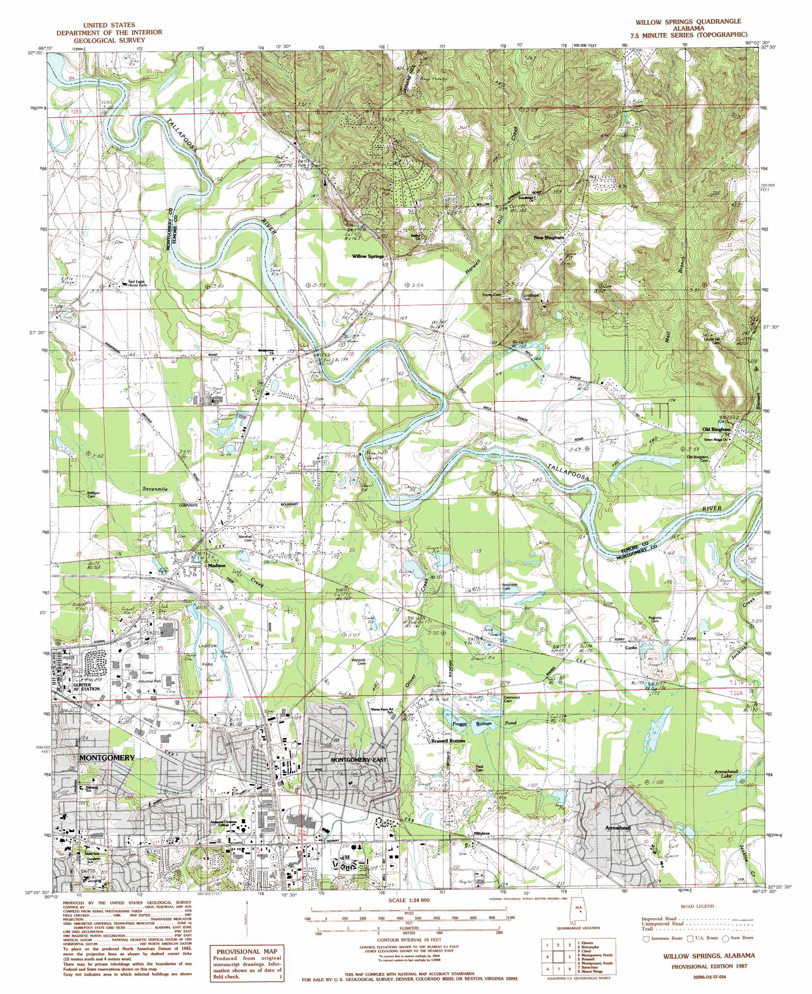
Willow Springs Topo Map Alabama
To zoom in, hover over the map of Willow Springs
USGS Topo Quad 32086d2 - 1:24,000 scale
| Topo Map Name: | Willow Springs |
| USGS Topo Quad ID: | 32086d2 |
| Print Size: | ca. 21 1/4" wide x 27" high |
| Southeast Coordinates: | 32.375° N latitude / 86.125° W longitude |
| Map Center Coordinates: | 32.4375° N latitude / 86.1875° W longitude |
| U.S. State: | AL |
| Filename: | o32086d2.jpg |
| Download Map JPG Image: | Willow Springs topo map 1:24,000 scale |
| Map Type: | Topographic |
| Topo Series: | 7.5´ |
| Map Scale: | 1:24,000 |
| Source of Map Images: | United States Geological Survey (USGS) |
| Alternate Map Versions: |
Mount Meigs NW AL 1975, updated 1977 Download PDF Buy paper map Willows Springs AL 1987, updated 1987 Download PDF Buy paper map Willows Springs AL 1987, updated 1987 Download PDF Buy paper map Willow Springs AL 2011 Download PDF Buy paper map Willow Springs AL 2014 Download PDF Buy paper map |
1:24,000 Topo Quads surrounding Willow Springs
Marbury |
Holtville |
Dexter |
Eclectic |
Red Hill |
Deatsville |
Elmore |
Wetumpka |
Claud |
Tallassee |
Prattville |
Montgomery North |
Willow Springs |
Brassell |
Shorter |
Cantelous |
Montgomery South |
Barachias |
Mount Meigs |
Chesson |
Letohatchee |
Snowdoun |
Davis Crossroads |
Teasleys Mill |
Fitzpatrick |
> Back to 32086a1 at 1:100,000 scale
> Back to 32086a1 at 1:250,000 scale
> Back to U.S. Topo Maps home
Willow Springs topo map: Gazetteer
Willow Springs: Crossings
Hughes Ferry (historical) elevation 37m 121′Judkins Ferry (historical) elevation 46m 150′
Winters Ferry (historical) elevation 37m 121′
Willow Springs: Parks
Goodwyn Park elevation 79m 259′Lagoon Park elevation 56m 183′
Willow Springs: Populated Places
Arrowhead elevation 70m 229′Azalea Woods Estates elevation 73m 239′
Bellehurst elevation 88m 288′
Blue Ridge elevation 112m 367′
Blue Ridge Estates elevation 81m 265′
Brassell Bottom elevation 55m 180′
College Grove elevation 70m 229′
Cooks elevation 52m 170′
Dalraida elevation 70m 229′
Eastmont elevation 70m 229′
Gunter Grove elevation 67m 219′
Jasmine Hill elevation 131m 429′
John Lee Acres elevation 52m 170′
Johnstown elevation 67m 219′
Johnstown East elevation 67m 219′
Kulumi (historical) elevation 53m 173′
Landmarks elevation 70m 229′
Madison elevation 53m 173′
Mitylene elevation 65m 213′
Montgomery East elevation 67m 219′
Mountain View Estates elevation 98m 321′
Muklassa (historical) elevation 59m 193′
New Bingham elevation 105m 344′
Old Bingham elevation 59m 193′
Redland Bluffs elevation 107m 351′
Sunshine Village elevation 64m 209′
Timbers elevation 66m 216′
Willow Springs elevation 52m 170′
Willow Springs: Reservoirs
Froggy Bottom Pond elevation 52m 170′Willow Springs: Streams
Brensen Branch elevation 43m 141′Harwell Mill Creek elevation 40m 131′
Marl Branch elevation 59m 193′
Willow Springs digital topo map on disk
Buy this Willow Springs topo map showing relief, roads, GPS coordinates and other geographical features, as a high-resolution digital map file on DVD:
Gulf Coast (LA, MS, AL, FL) & Southwestern Georgia
Buy digital topo maps: Gulf Coast (LA, MS, AL, FL) & Southwestern Georgia
 & Southwestern Georgia map DVD")