Forester Topo Map Alabama
To zoom in, hover over the map of Forester
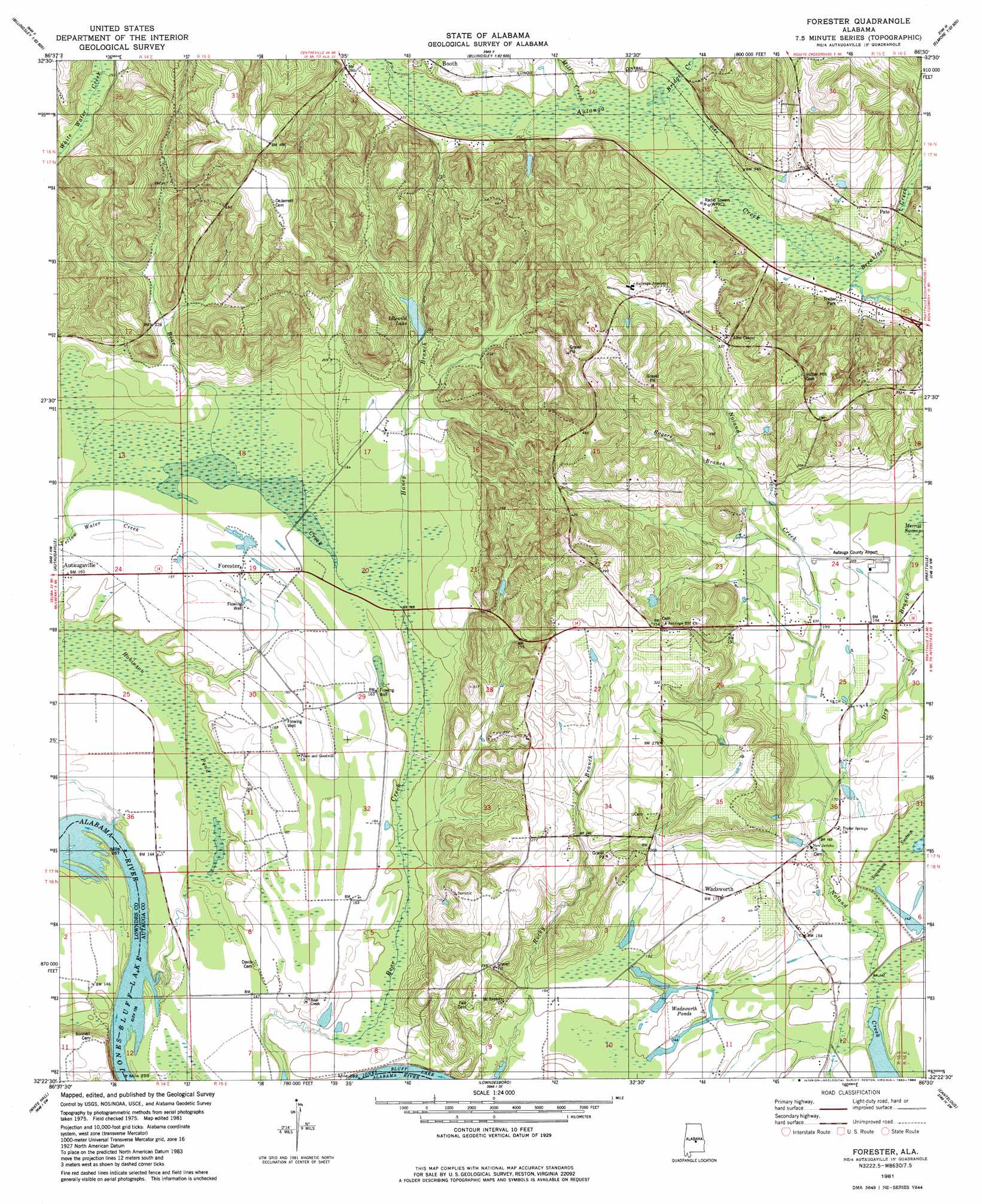
USGS Topo Quad 32086d5 - 1:24,000 scale
| Topo Map Name: | Forester |
| USGS Topo Quad ID: | 32086d5 |
| Print Size: | ca. 21 1/4" wide x 27" high |
| Southeast Coordinates: | 32.375° N latitude / 86.5° W longitude |
| Map Center Coordinates: | 32.4375° N latitude / 86.5625° W longitude |
| U.S. State: | AL |
| Filename: | o32086d5.jpg |
| Download Map JPG Image: | Forester topo map 1:24,000 scale |
| Map Type: | Topographic |
| Topo Series: | 7.5´ |
| Map Scale: | 1:24,000 |
| Source of Map Images: | United States Geological Survey (USGS) |
| Alternate Map Versions: |
Autaugaville NE AL 1975, updated 1977 Download PDF Buy paper map Forester AL 1981, updated 1982 Download PDF Buy paper map Forester AL 1981, updated 1984 Download PDF Buy paper map Forester AL 2011 Download PDF Buy paper map Forester AL 2014 Download PDF Buy paper map |
1:24,000 Topo Quads surrounding Forester
Pletcher |
Billingsley |
White City |
Marbury |
Holtville |
Milton |
Vida |
Old Kingston |
Deatsville |
Elmore |
Durant Bend |
Autaugaville |
Forester |
Prattville |
Montgomery North |
Benton |
White Hall |
Lowndesboro |
Cantelous |
Montgomery South |
Collirene |
Gordonsville |
Hayneville |
Letohatchee |
Snowdoun |
> Back to 32086a1 at 1:100,000 scale
> Back to 32086a1 at 1:250,000 scale
> Back to U.S. Topo Maps home
Forester topo map: Gazetteer
Forester: Airports
Autauga County Airport elevation 61m 200′Forester: Crossings
Newport Ferry (historical) elevation 38m 124′Forester: Dams
Idlewood Lake Dam elevation 71m 232′Forester: Lakes
Gum Cypress Lake (historical) elevation 45m 147′Forester: Populated Places
Forester elevation 49m 160′Old Vernon (historical) elevation 42m 137′
Pate elevation 79m 259′
Wadsworth elevation 52m 170′
Forester: Post Offices
Indian Springs Post Office (historical) elevation 140m 459′Forester: Reservoirs
Idlewild Lake elevation 68m 223′Wadsworth Ponds elevation 43m 141′
Forester: Streams
Breakfast Creek elevation 62m 203′Bridge Creek elevation 67m 219′
Dry Branch elevation 49m 160′
Haney Branch elevation 48m 157′
Mill Creek elevation 70m 229′
Rogers Branch elevation 76m 249′
Forester: Swamps
Bear Creek Swamp elevation 46m 150′Bear Swamp elevation 48m 157′
Merritt Swamp elevation 59m 193′
Robinson Pond elevation 42m 137′
Forester digital topo map on disk
Buy this Forester topo map showing relief, roads, GPS coordinates and other geographical features, as a high-resolution digital map file on DVD:
Gulf Coast (LA, MS, AL, FL) & Southwestern Georgia
Buy digital topo maps: Gulf Coast (LA, MS, AL, FL) & Southwestern Georgia
 & Southwestern Georgia map DVD")