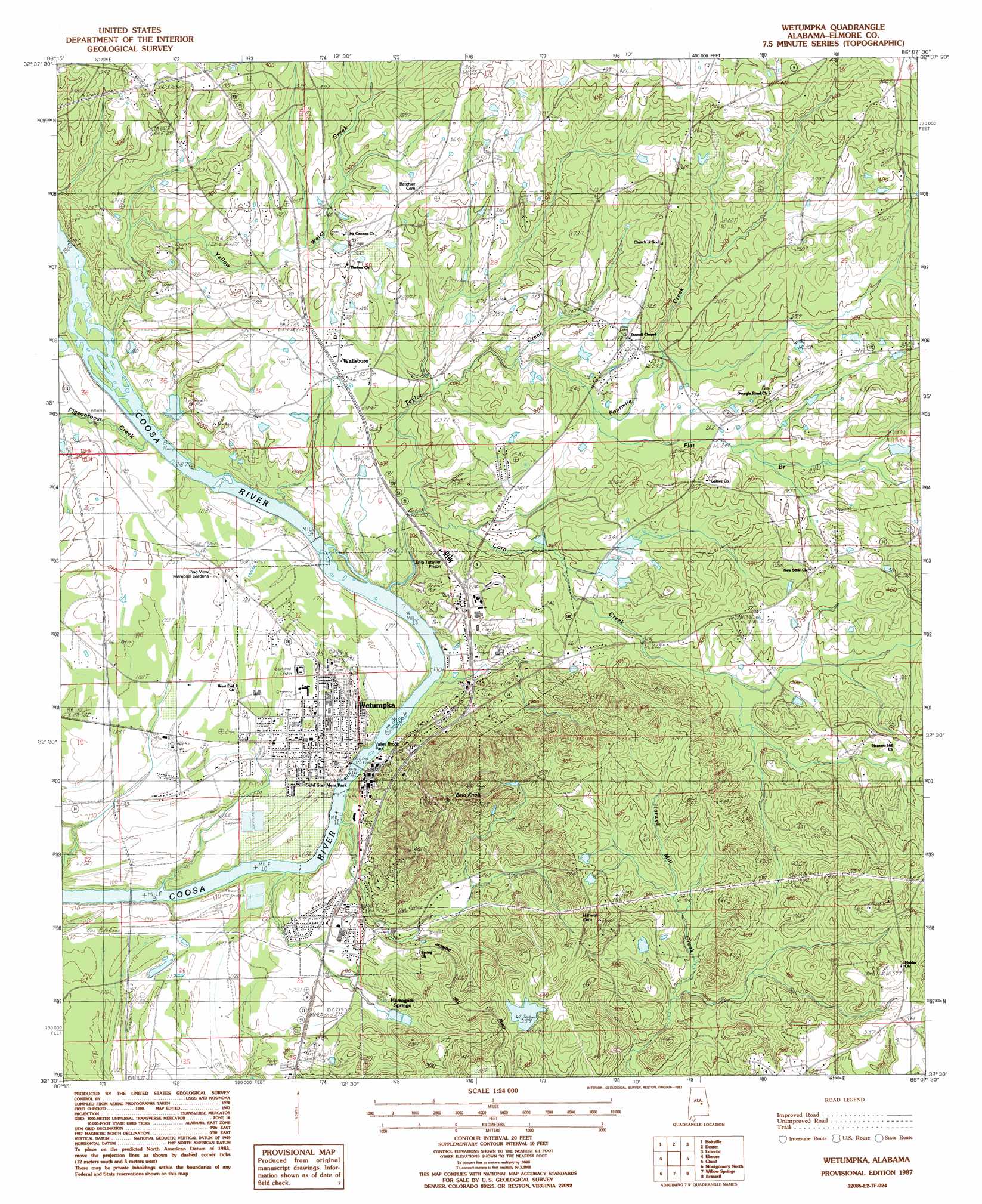
Wetumpka Topo Map Alabama
To zoom in, hover over the map of Wetumpka
USGS Topo Quad 32086e2 - 1:24,000 scale
| Topo Map Name: | Wetumpka |
| USGS Topo Quad ID: | 32086e2 |
| Print Size: | ca. 21 1/4" wide x 27" high |
| Southeast Coordinates: | 32.5° N latitude / 86.125° W longitude |
| Map Center Coordinates: | 32.5625° N latitude / 86.1875° W longitude |
| U.S. State: | AL |
| Filename: | o32086e2.jpg |
| Download Map JPG Image: | Wetumpka topo map 1:24,000 scale |
| Map Type: | Topographic |
| Topo Series: | 7.5´ |
| Map Scale: | 1:24,000 |
| Source of Map Images: | United States Geological Survey (USGS) |
| Alternate Map Versions: |
Wetumpka SW AL 1975, updated 1977 Download PDF Buy paper map Wetumpka AL 1987 Download PDF Buy paper map Wetumpka AL 1987, updated 1987 Download PDF Buy paper map Wetumpka AL 2011 Download PDF Buy paper map Wetumpka AL 2014 Download PDF Buy paper map |
1:24,000 Topo Quads surrounding Wetumpka
Mitchell Dam |
Richville |
Rockford Sw |
Equality |
Our Town |
Marbury |
Holtville |
Dexter |
Eclectic |
Red Hill |
Deatsville |
Elmore |
Wetumpka |
Claud |
Tallassee |
Prattville |
Montgomery North |
Willow Springs |
Brassell |
Shorter |
Cantelous |
Montgomery South |
Barachias |
Mount Meigs |
Chesson |
> Back to 32086e1 at 1:100,000 scale
> Back to 32086a1 at 1:250,000 scale
> Back to U.S. Topo Maps home
Wetumpka topo map: Gazetteer
Wetumpka: Bars
Corn Creek Shoals elevation 41m 134′Grays Island Shoal elevation 50m 164′
Moccasin Shoals elevation 42m 137′
Wetumpka: Bridges
Bibb Graves Bridge elevation 39m 127′Wetumpka: Dams
Crommelin Lake Dam elevation 70m 229′Fitzpatrick Dam elevation 101m 331′
Wetumpka: Falls
Wetumpka Falls elevation 39m 127′Wetumpka: Parks
East Wetumpka Commercial Historic District elevation 58m 190′Gold Star Park elevation 43m 141′
Hohenberg Field elevation 55m 180′
Meadowbrook Park elevation 56m 183′
Memorial Park elevation 55m 180′
Valley Brook Park elevation 50m 164′
Wetumpka Municipal Park elevation 55m 180′
Wetumpka: Populated Places
Blueberry Hill elevation 75m 246′Cherokee Estates elevation 76m 249′
Harrogate Springs elevation 70m 229′
Quail Run elevation 57m 187′
Saint Clair elevation 55m 180′
Tarwater elevation 72m 236′
Wallsboro elevation 74m 242′
Wetumpka elevation 55m 180′
Wetumpka: Post Offices
Wetumpka Post Office elevation 53m 173′Wetumpka: Reservoirs
Crommelin Lake elevation 70m 229′Fitzpatrick Lake elevation 101m 331′
Wetumpka: Streams
Corn Creek elevation 41m 134′Flat Branch elevation 71m 232′
Fourmile Creek elevation 64m 209′
Pigeonroost Creek elevation 49m 160′
Taylor Creek elevation 49m 160′
Yellow Water Creek elevation 45m 147′
Wetumpka: Summits
Bald Knob elevation 115m 377′Wetumpka digital topo map on disk
Buy this Wetumpka topo map showing relief, roads, GPS coordinates and other geographical features, as a high-resolution digital map file on DVD:
Gulf Coast (LA, MS, AL, FL) & Southwestern Georgia
Buy digital topo maps: Gulf Coast (LA, MS, AL, FL) & Southwestern Georgia
 & Southwestern Georgia map DVD")