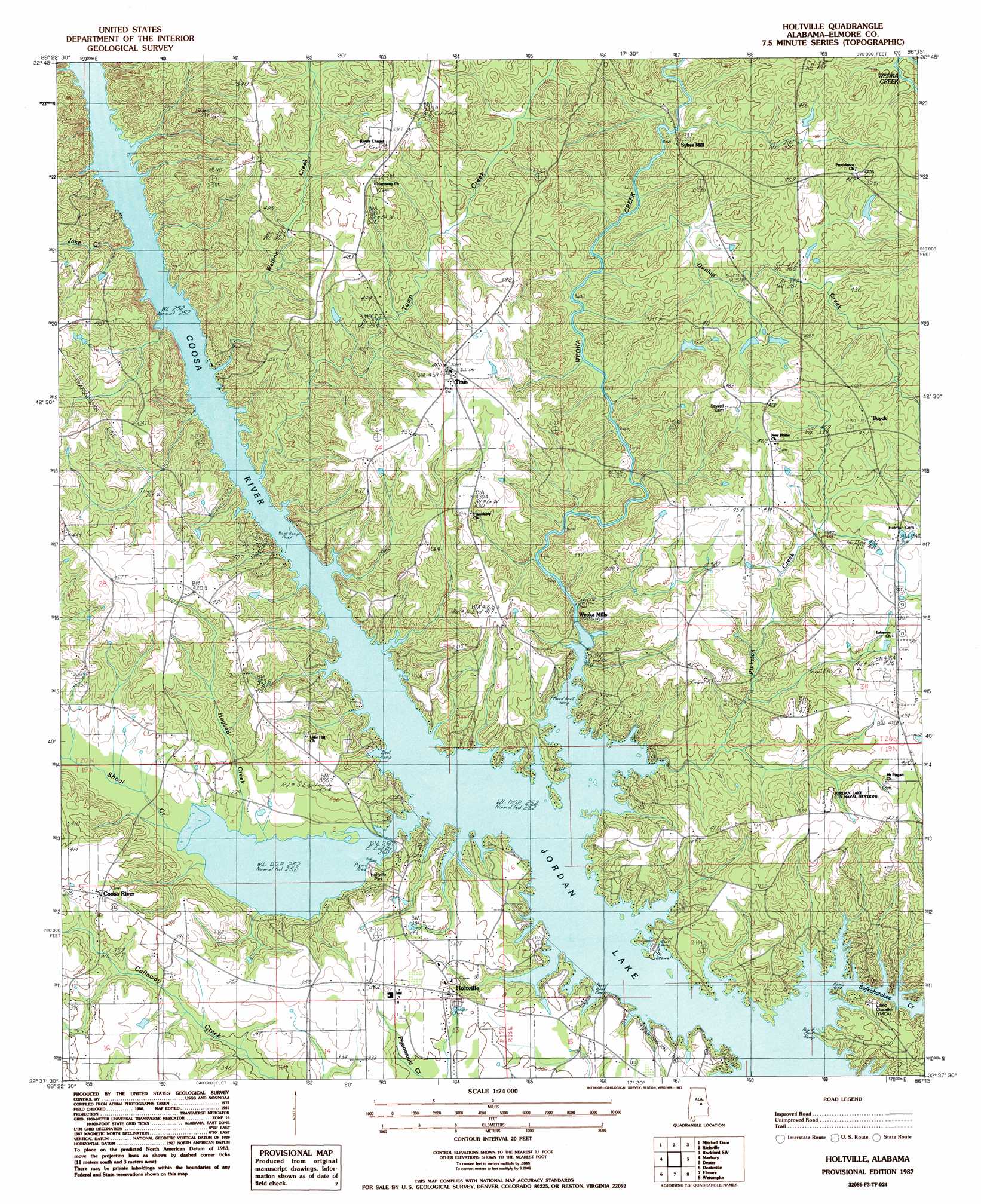
Holtville Topo Map Alabama
To zoom in, hover over the map of Holtville
USGS Topo Quad 32086f3 - 1:24,000 scale
| Topo Map Name: | Holtville |
| USGS Topo Quad ID: | 32086f3 |
| Print Size: | ca. 21 1/4" wide x 27" high |
| Southeast Coordinates: | 32.625° N latitude / 86.25° W longitude |
| Map Center Coordinates: | 32.6875° N latitude / 86.3125° W longitude |
| U.S. State: | AL |
| Filename: | o32086f3.jpg |
| Download Map JPG Image: | Holtville topo map 1:24,000 scale |
| Map Type: | Topographic |
| Topo Series: | 7.5´ |
| Map Scale: | 1:24,000 |
| Source of Map Images: | United States Geological Survey (USGS) |
| Alternate Map Versions: |
Holtville AL 1987, updated 1987 Download PDF Buy paper map Holtville AL 2011 Download PDF Buy paper map Holtville AL 2014 Download PDF Buy paper map |
1:24,000 Topo Quads surrounding Holtville
Lay Dam |
Mitchell Dam Nw |
Flag Mountain |
Rockford |
Kellyton |
Clanton East |
Mitchell Dam |
Richville |
Rockford Sw |
Equality |
White City |
Marbury |
Holtville |
Dexter |
Eclectic |
Old Kingston |
Deatsville |
Elmore |
Wetumpka |
Claud |
Forester |
Prattville |
Montgomery North |
Willow Springs |
Brassell |
> Back to 32086e1 at 1:100,000 scale
> Back to 32086a1 at 1:250,000 scale
> Back to U.S. Topo Maps home
Holtville topo map: Gazetteer
Holtville: Crossings
Morris Ferry (historical) elevation 77m 252′Nobles Ferry (historical) elevation 77m 252′
Wadsworths Old Ferry (historical) elevation 77m 252′
Holtville: Parks
Holtville Park elevation 90m 295′Holtville: Populated Places
Buyck elevation 140m 459′Coosa River elevation 125m 410′
Holtville elevation 108m 354′
Titus elevation 142m 465′
Weoka Mills elevation 79m 259′
Holtville: Post Offices
Little York Post Office (historical) elevation 91m 298′Titus Post Office elevation 141m 462′
Holtville: Streams
Big Branch elevation 79m 259′Dunlap Creek elevation 96m 314′
Gennie Branch elevation 77m 252′
Hogbed Creek elevation 77m 252′
Jake Creek elevation 77m 252′
Pinkston Creek elevation 77m 252′
Shoal Creek elevation 77m 252′
Sofkahatchee Creek elevation 77m 252′
Tan Trough Creek elevation 82m 269′
Town Creek elevation 79m 259′
Trash Branch elevation 78m 255′
Welona Creek elevation 79m 259′
Weoka Creek elevation 77m 252′
Holtville digital topo map on disk
Buy this Holtville topo map showing relief, roads, GPS coordinates and other geographical features, as a high-resolution digital map file on DVD:
Gulf Coast (LA, MS, AL, FL) & Southwestern Georgia
Buy digital topo maps: Gulf Coast (LA, MS, AL, FL) & Southwestern Georgia
 & Southwestern Georgia map DVD")