Kellyton Topo Map Alabama
To zoom in, hover over the map of Kellyton
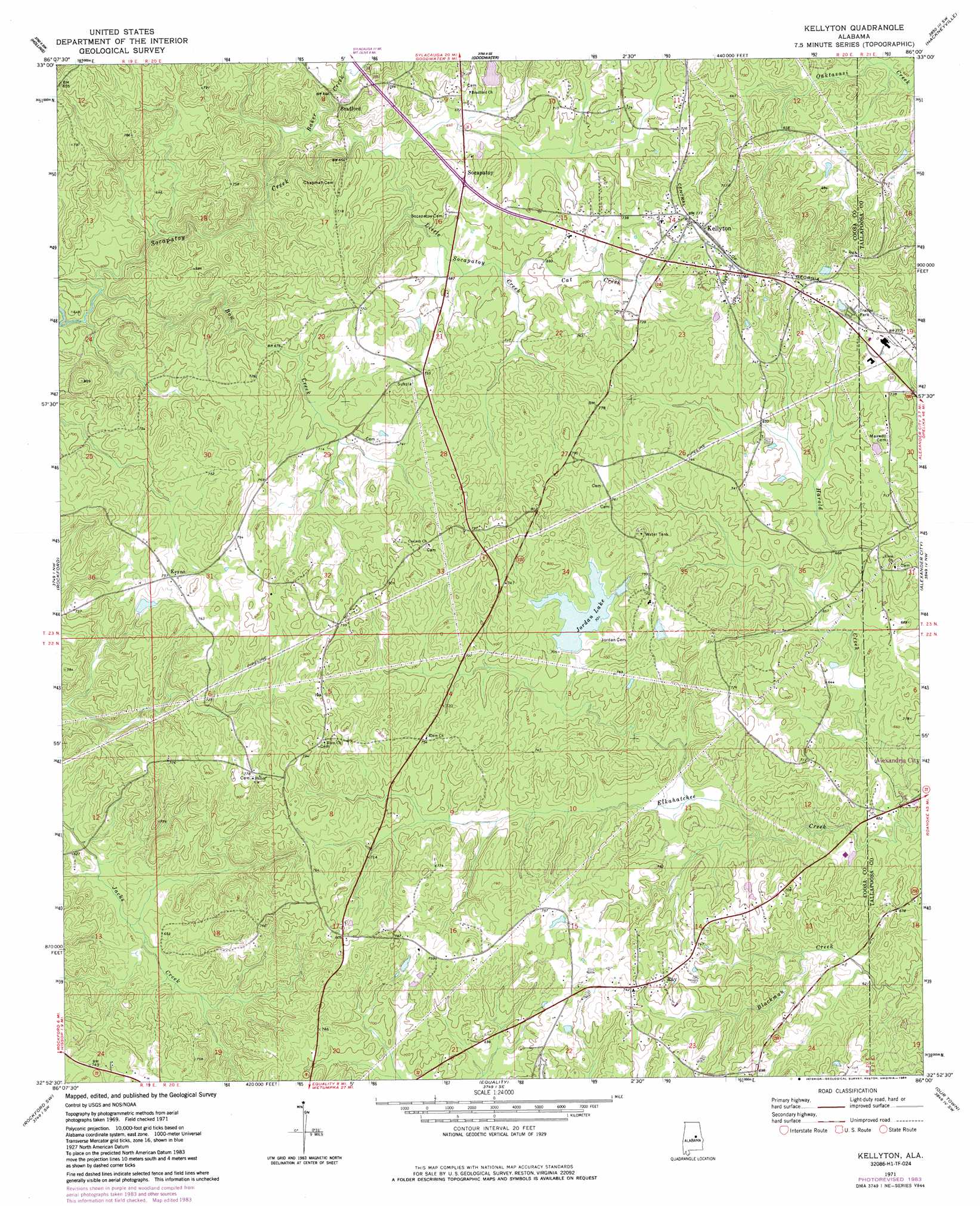
USGS Topo Quad 32086h1 - 1:24,000 scale
| Topo Map Name: | Kellyton |
| USGS Topo Quad ID: | 32086h1 |
| Print Size: | ca. 21 1/4" wide x 27" high |
| Southeast Coordinates: | 32.875° N latitude / 86° W longitude |
| Map Center Coordinates: | 32.9375° N latitude / 86.0625° W longitude |
| U.S. State: | AL |
| Filename: | o32086h1.jpg |
| Download Map JPG Image: | Kellyton topo map 1:24,000 scale |
| Map Type: | Topographic |
| Topo Series: | 7.5´ |
| Map Scale: | 1:24,000 |
| Source of Map Images: | United States Geological Survey (USGS) |
| Alternate Map Versions: |
Kellyton AL 1971, updated 1973 Download PDF Buy paper map Kellyton AL 1971, updated 1984 Download PDF Buy paper map Kellyton AL 2011 Download PDF Buy paper map Kellyton AL 2014 Download PDF Buy paper map |
1:24,000 Topo Quads surrounding Kellyton
Sylacauga West |
Sylacauga East |
Bulls Gap |
Millerville |
Gibsonville |
Weogufka |
Hollins |
Goodwater |
Hackneyville |
New Site |
Flag Mountain |
Rockford |
Kellyton |
Alexander City |
Jacksons Gap |
Richville |
Rockford Sw |
Equality |
Our Town |
Dadeville |
Holtville |
Dexter |
Eclectic |
Red Hill |
Ponders |
> Back to 32086e1 at 1:100,000 scale
> Back to 32086a1 at 1:250,000 scale
> Back to U.S. Topo Maps home
Kellyton topo map: Gazetteer
Kellyton: Dams
Ann Jordan Lake Dam elevation 207m 679′Brooks Farm Pond Dam elevation 226m 741′
Walls Lake Dam elevation 208m 682′
Kellyton: Parks
Ann Jordan Resort Area elevation 219m 718′Kellyton: Populated Places
Bradford elevation 199m 652′Jon elevation 227m 744′
Kellyton elevation 232m 761′
Keyno elevation 230m 754′
Ray elevation 223m 731′
Socapatoy elevation 228m 748′
Kellyton: Post Offices
Kellyton Post Office elevation 228m 748′Kellyton: Reservoirs
Brooks Farm Pond elevation 226m 741′Dunnings Pond elevation 212m 695′
Hallmans Lake elevation 228m 748′
Holdridge Pond elevation 210m 688′
Jones Pond elevation 226m 741′
Jordan Lake elevation 213m 698′
Nibletts Pond elevation 223m 731′
Swan Lake elevation 219m 718′
Walls Lake elevation 208m 682′
Kellyton: Streams
Baker Creek elevation 202m 662′Bow Creek elevation 174m 570′
Cat Creek elevation 207m 679′
Harold Creek elevation 188m 616′
Little Socapatoy Creek elevation 197m 646′
Kellyton digital topo map on disk
Buy this Kellyton topo map showing relief, roads, GPS coordinates and other geographical features, as a high-resolution digital map file on DVD:
Gulf Coast (LA, MS, AL, FL) & Southwestern Georgia
Buy digital topo maps: Gulf Coast (LA, MS, AL, FL) & Southwestern Georgia
 & Southwestern Georgia map DVD")