Crumptonia Topo Map Alabama
To zoom in, hover over the map of Crumptonia
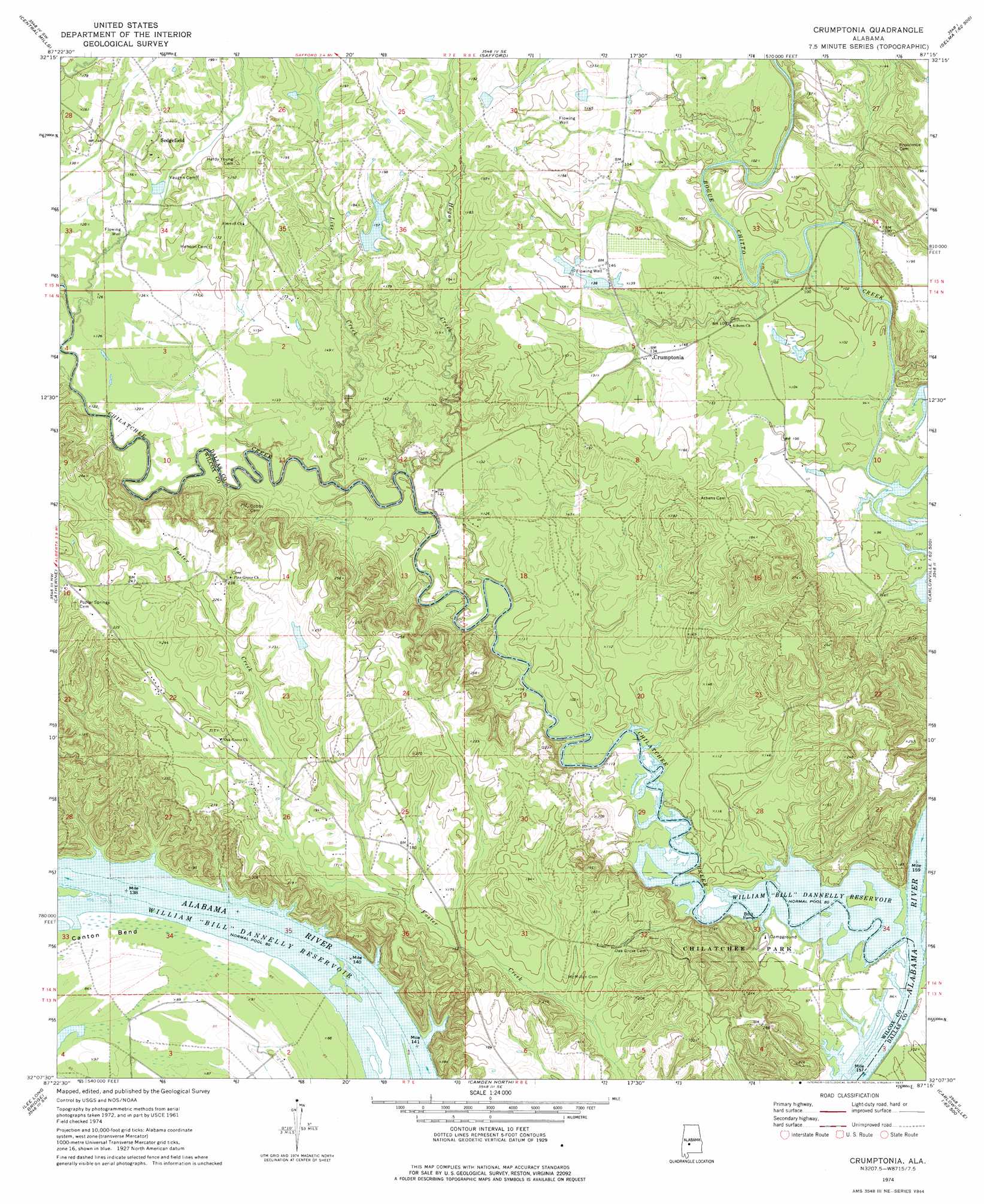
USGS Topo Quad 32087b3 - 1:24,000 scale
| Topo Map Name: | Crumptonia |
| USGS Topo Quad ID: | 32087b3 |
| Print Size: | ca. 21 1/4" wide x 27" high |
| Southeast Coordinates: | 32.125° N latitude / 87.25° W longitude |
| Map Center Coordinates: | 32.1875° N latitude / 87.3125° W longitude |
| U.S. State: | AL |
| Filename: | o32087b3.jpg |
| Download Map JPG Image: | Crumptonia topo map 1:24,000 scale |
| Map Type: | Topographic |
| Topo Series: | 7.5´ |
| Map Scale: | 1:24,000 |
| Source of Map Images: | United States Geological Survey (USGS) |
| Alternate Map Versions: |
Crumptonia AL 1974, updated 1977 Download PDF Buy paper map Crumptonia AL 2011 Download PDF Buy paper map Crumptonia AL 2014 Download PDF Buy paper map |
1:24,000 Topo Quads surrounding Crumptonia
Uniontown West |
Uniontown East |
Browns |
Marion Junction |
Selma |
Thomaston East |
Central Mills |
Safford |
Orrville |
Blackwell Bend |
Flatwood |
Catherine |
Crumptonia |
Tasso |
Elm Bluff |
Kimbrough |
Lee Long Bridge |
Camden North |
Tilden |
Carlowville |
Pine Hill |
Coy |
Camden South |
Rosebud |
Oak Hill |
> Back to 32087a1 at 1:100,000 scale
> Back to 32086a1 at 1:250,000 scale
> Back to U.S. Topo Maps home
Crumptonia topo map: Gazetteer
Crumptonia: Cliffs
Red Bluff elevation 28m 91′Crumptonia: Dams
Sedgefield Lake Dam elevation 55m 180′Crumptonia: Parks
Chilatchee Park elevation 30m 98′Crumptonia: Populated Places
Cobbs Quarters elevation 37m 121′Crumptonia elevation 43m 141′
Sedgefield elevation 55m 180′
Crumptonia: Post Offices
Cambridge Post Office (historical) elevation 43m 141′Retreat Post Office (historical) elevation 51m 167′
Crumptonia: Reservoirs
Sedgefield Lake elevation 55m 180′Crumptonia: Streams
Chilatchee Creek elevation 24m 78′Hogan Creek elevation 30m 98′
Lize Creek elevation 28m 91′
Crumptonia digital topo map on disk
Buy this Crumptonia topo map showing relief, roads, GPS coordinates and other geographical features, as a high-resolution digital map file on DVD:
Gulf Coast (LA, MS, AL, FL) & Southwestern Georgia
Buy digital topo maps: Gulf Coast (LA, MS, AL, FL) & Southwestern Georgia
 & Southwestern Georgia map DVD")