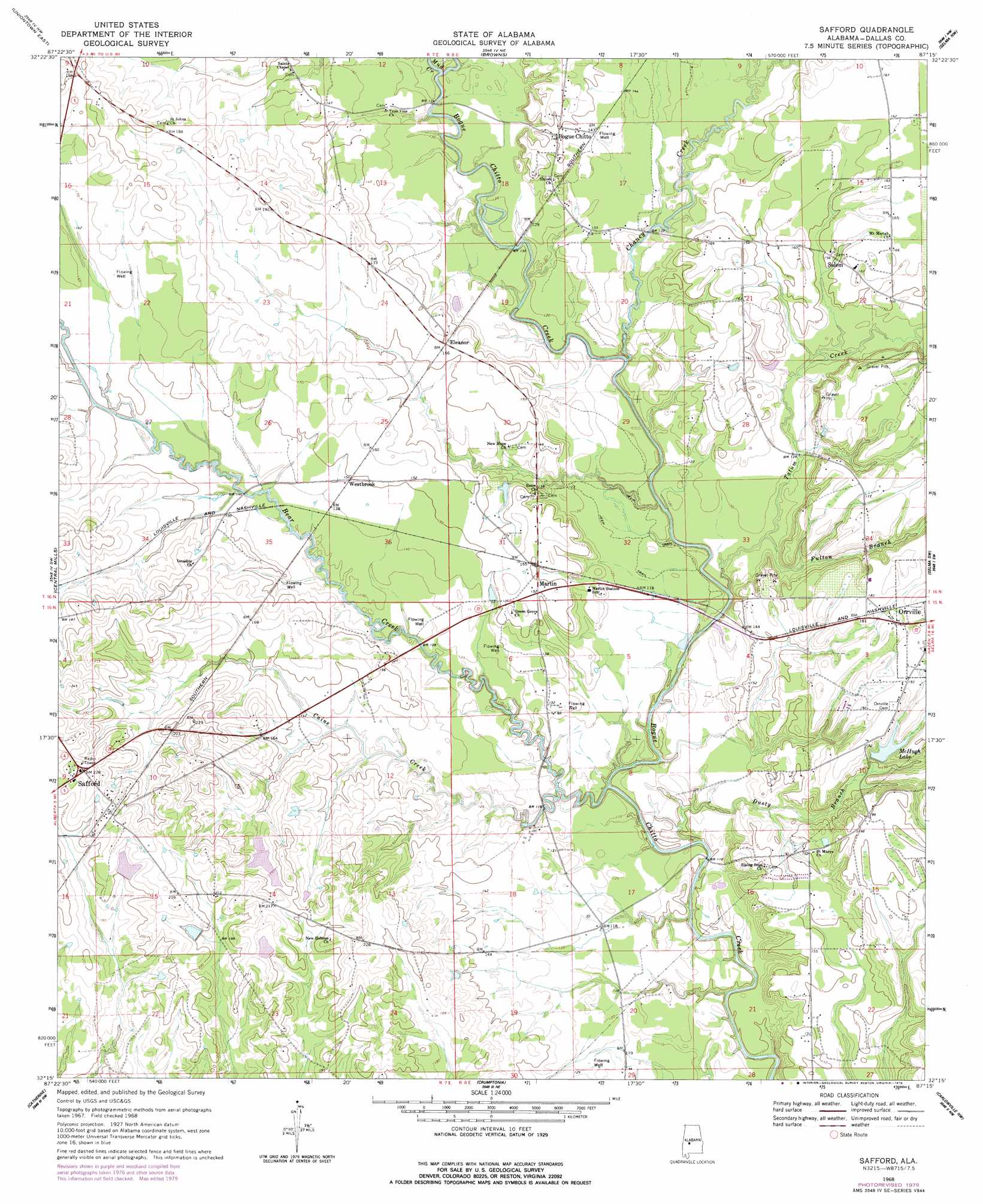
Safford Topo Map Alabama
To zoom in, hover over the map of Safford
USGS Topo Quad 32087c3 - 1:24,000 scale
| Topo Map Name: | Safford |
| USGS Topo Quad ID: | 32087c3 |
| Print Size: | ca. 21 1/4" wide x 27" high |
| Southeast Coordinates: | 32.25° N latitude / 87.25° W longitude |
| Map Center Coordinates: | 32.3125° N latitude / 87.3125° W longitude |
| U.S. State: | AL |
| Filename: | o32087c3.jpg |
| Download Map JPG Image: | Safford topo map 1:24,000 scale |
| Map Type: | Topographic |
| Topo Series: | 7.5´ |
| Map Scale: | 1:24,000 |
| Source of Map Images: | United States Geological Survey (USGS) |
| Alternate Map Versions: |
Safford AL 1968, updated 1971 Download PDF Buy paper map Safford AL 1968, updated 1979 Download PDF Buy paper map Safford AL 2011 Download PDF Buy paper map Safford AL 2014 Download PDF Buy paper map |
1:24,000 Topo Quads surrounding Safford
Newbern |
Scott Station |
Marion South |
Suttle |
Summerfield |
Uniontown West |
Uniontown East |
Browns |
Marion Junction |
Selma |
Thomaston East |
Central Mills |
Safford |
Orrville |
Blackwell Bend |
Flatwood |
Catherine |
Crumptonia |
Tasso |
Elm Bluff |
Kimbrough |
Lee Long Bridge |
Camden North |
Tilden |
Carlowville |
> Back to 32087a1 at 1:100,000 scale
> Back to 32086a1 at 1:250,000 scale
> Back to U.S. Topo Maps home
Safford topo map: Gazetteer
Safford: Dams
E Ables Lake Dam elevation 65m 213′McHugh Lake Dam elevation 46m 150′
Safford: Populated Places
Bogue Chitto elevation 46m 150′Brookwood elevation 47m 154′
Eleanor elevation 48m 157′
Martin elevation 46m 150′
Safford elevation 70m 229′
Salem elevation 47m 154′
Westbrook elevation 45m 147′
Safford: Post Offices
Safford Post Office elevation 68m 223′Safford: Reservoirs
E Ables Lake elevation 65m 213′McHugh Lake elevation 50m 164′
Safford: Streams
Bear Creek elevation 27m 88′Caine Creek elevation 29m 95′
Chaney Creek elevation 31m 101′
Dusty Branch elevation 29m 95′
Fulton Branch elevation 32m 104′
Kendricks Branch elevation 40m 131′
Mud Creek elevation 32m 104′
Tatum Creek elevation 31m 101′
Safford digital topo map on disk
Buy this Safford topo map showing relief, roads, GPS coordinates and other geographical features, as a high-resolution digital map file on DVD:
Gulf Coast (LA, MS, AL, FL) & Southwestern Georgia
Buy digital topo maps: Gulf Coast (LA, MS, AL, FL) & Southwestern Georgia
 & Southwestern Georgia map DVD")