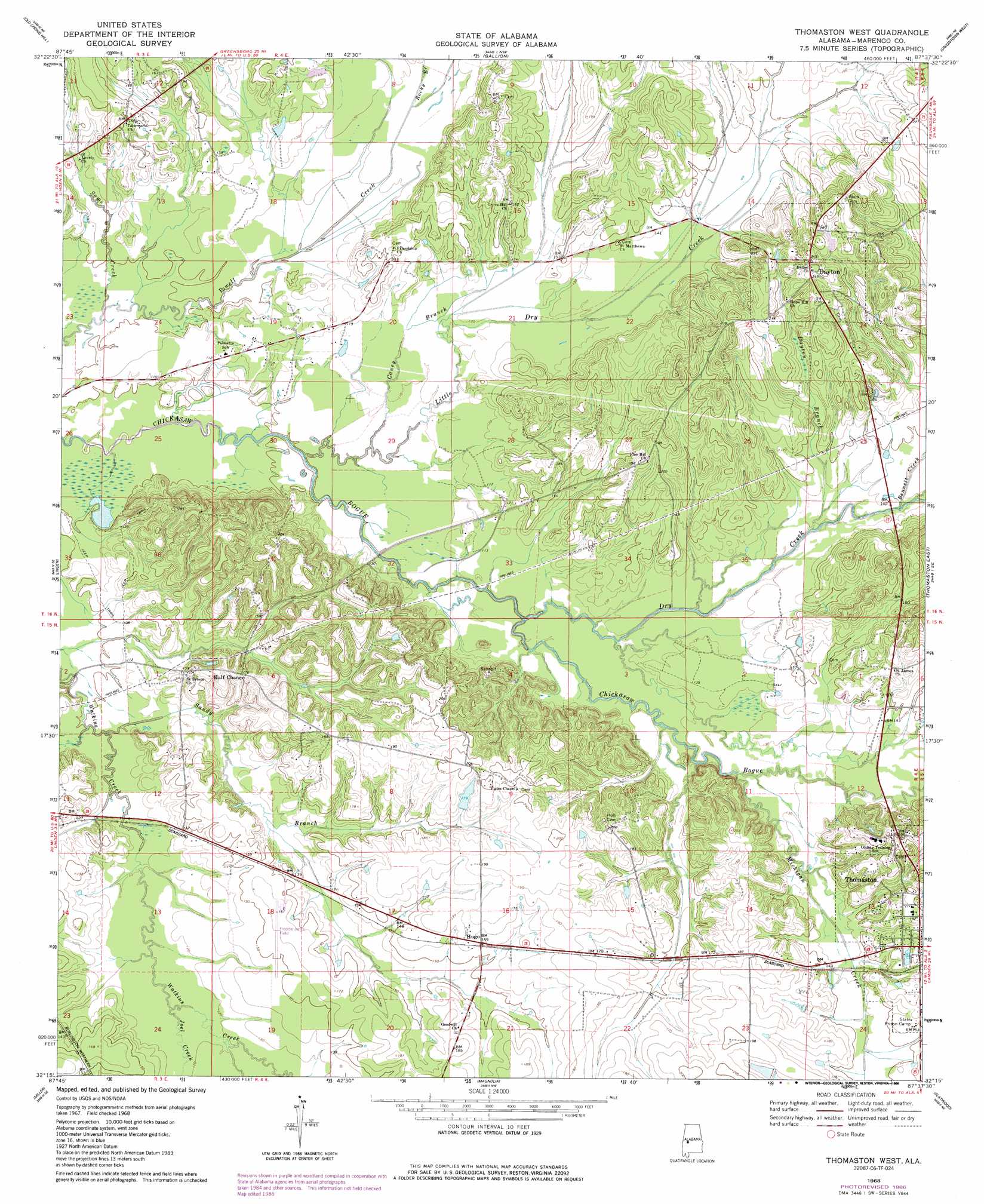
Thomaston West Topo Map Alabama
To zoom in, hover over the map of Thomaston West
USGS Topo Quad 32087c6 - 1:24,000 scale
| Topo Map Name: | Thomaston West |
| USGS Topo Quad ID: | 32087c6 |
| Print Size: | ca. 21 1/4" wide x 27" high |
| Southeast Coordinates: | 32.25° N latitude / 87.625° W longitude |
| Map Center Coordinates: | 32.3125° N latitude / 87.6875° W longitude |
| U.S. State: | AL |
| Filename: | o32087c6.jpg |
| Download Map JPG Image: | Thomaston West topo map 1:24,000 scale |
| Map Type: | Topographic |
| Topo Series: | 7.5´ |
| Map Scale: | 1:24,000 |
| Source of Map Images: | United States Geological Survey (USGS) |
| Alternate Map Versions: |
Thomaston West AL 1968, updated 1971 Download PDF Buy paper map Thomaston West AL 1968, updated 1986 Download PDF Buy paper map Thomaston West AL 2011 Download PDF Buy paper map Thomaston West AL 2014 Download PDF Buy paper map |
1:24,000 Topo Quads surrounding Thomaston West
Mcdowell |
Demopolis |
Casemore |
Newbern |
Scott Station |
Jefferson |
Old Spring Hill |
Gallion |
Uniontown West |
Uniontown East |
Myrtlewood North |
Linden |
Thomaston West |
Thomaston East |
Central Mills |
Myrtlewood South |
Miller |
Magnolia |
Flatwood |
Catherine |
Nanafalia |
Sweet Water |
Surginer |
Kimbrough |
Lee Long Bridge |
> Back to 32087a1 at 1:100,000 scale
> Back to 32086a1 at 1:250,000 scale
> Back to U.S. Topo Maps home
Thomaston West topo map: Gazetteer
Thomaston West: Airports
Linden Municipal Airport elevation 48m 157′Thomaston West: Dams
Mitchell Dam elevation 58m 190′Whitley Dam elevation 54m 177′
Thomaston West: Parks
Eagles Stadium elevation 60m 196′Thomaston West: Populated Places
Dayton elevation 74m 242′Half Chance elevation 56m 183′
Hugo elevation 49m 160′
Thomaston elevation 57m 187′
Thomaston West: Reservoirs
Mitchell Lake elevation 58m 190′Whitley Lake elevation 54m 177′
Thomaston West: Streams
Bennett Creek elevation 39m 127′Caney Branch elevation 31m 101′
Dayton Branch elevation 35m 114′
Dry Creek elevation 30m 98′
Joel Creek elevation 34m 111′
Little Dry Creek elevation 27m 88′
Michigan Creek elevation 35m 114′
Rocky Branch elevation 34m 111′
Sams Creek elevation 27m 88′
Sandy Branch elevation 30m 98′
Thomaston West digital topo map on disk
Buy this Thomaston West topo map showing relief, roads, GPS coordinates and other geographical features, as a high-resolution digital map file on DVD:
Gulf Coast (LA, MS, AL, FL) & Southwestern Georgia
Buy digital topo maps: Gulf Coast (LA, MS, AL, FL) & Southwestern Georgia
 & Southwestern Georgia map DVD")