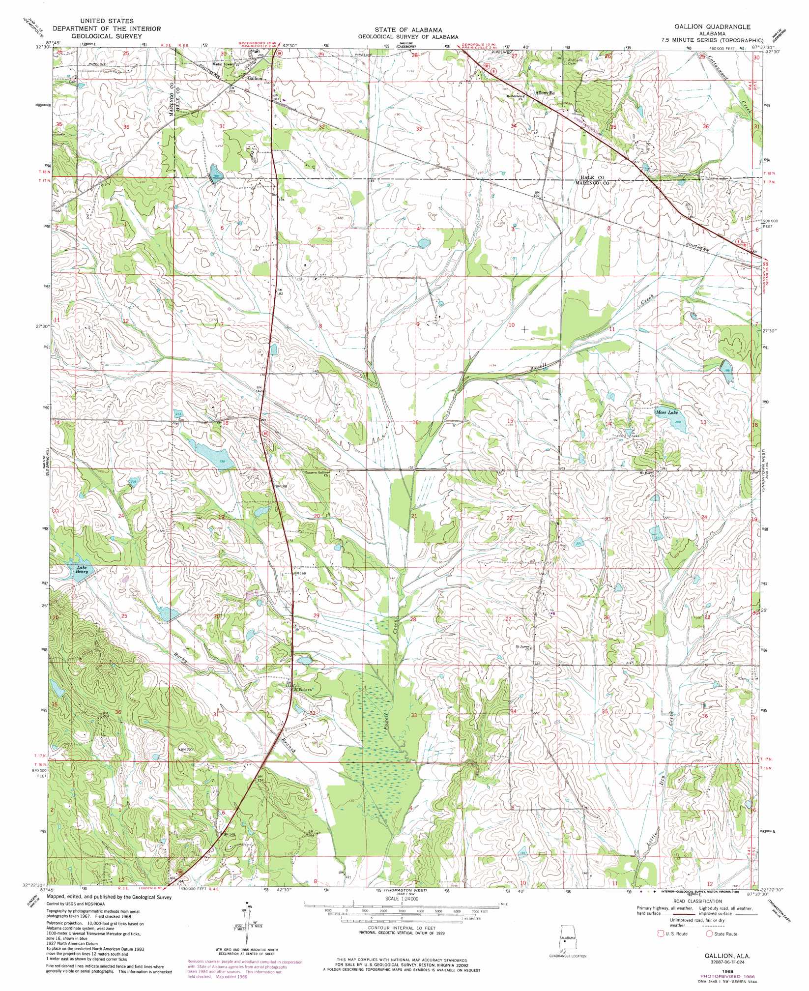
Gallion Topo Map Alabama
To zoom in, hover over the map of Gallion
USGS Topo Quad 32087d6 - 1:24,000 scale
| Topo Map Name: | Gallion |
| USGS Topo Quad ID: | 32087d6 |
| Print Size: | ca. 21 1/4" wide x 27" high |
| Southeast Coordinates: | 32.375° N latitude / 87.625° W longitude |
| Map Center Coordinates: | 32.4375° N latitude / 87.6875° W longitude |
| U.S. State: | AL |
| Filename: | o32087d6.jpg |
| Download Map JPG Image: | Gallion topo map 1:24,000 scale |
| Map Type: | Topographic |
| Topo Series: | 7.5´ |
| Map Scale: | 1:24,000 |
| Source of Map Images: | United States Geological Survey (USGS) |
| Alternate Map Versions: |
Gallion AL 1968, updated 1971 Download PDF Buy paper map Gallion AL 1968, updated 1984 Download PDF Buy paper map Gallion AL 1968, updated 1986 Download PDF Buy paper map Gallion AL 2011 Download PDF Buy paper map Gallion AL 2014 Download PDF Buy paper map |
1:24,000 Topo Quads surrounding Gallion
Forkland |
Mason Bend |
Melton |
Greensboro |
Morgan Springs |
Mcdowell |
Demopolis |
Casemore |
Newbern |
Scott Station |
Jefferson |
Old Spring Hill |
Gallion |
Uniontown West |
Uniontown East |
Myrtlewood North |
Linden |
Thomaston West |
Thomaston East |
Central Mills |
Myrtlewood South |
Miller |
Magnolia |
Flatwood |
Catherine |
> Back to 32087a1 at 1:100,000 scale
> Back to 32086a1 at 1:250,000 scale
> Back to U.S. Topo Maps home
Gallion topo map: Gazetteer
Gallion: Dams
Bethea Dam elevation 60m 196′N B Fields Lake Dam elevation 63m 206′
Powell Creek Number 7 Dam elevation 58m 190′
Powell Creek Number 8 Dam elevation 52m 170′
Spencer Dam Number Two elevation 52m 170′
Gallion: Populated Places
Allenville elevation 64m 209′Gallion elevation 58m 190′
Tombigbee (historical) elevation 67m 219′
Gallion: Reservoirs
Fields Lake elevation 63m 206′Lake Henry elevation 57m 187′
Moss Lake elevation 61m 200′
Powell Creek Lake Number Eight elevation 52m 170′
Spencer Lake Two elevation 52m 170′
Gallion digital topo map on disk
Buy this Gallion topo map showing relief, roads, GPS coordinates and other geographical features, as a high-resolution digital map file on DVD:
Gulf Coast (LA, MS, AL, FL) & Southwestern Georgia
Buy digital topo maps: Gulf Coast (LA, MS, AL, FL) & Southwestern Georgia
 & Southwestern Georgia map DVD")