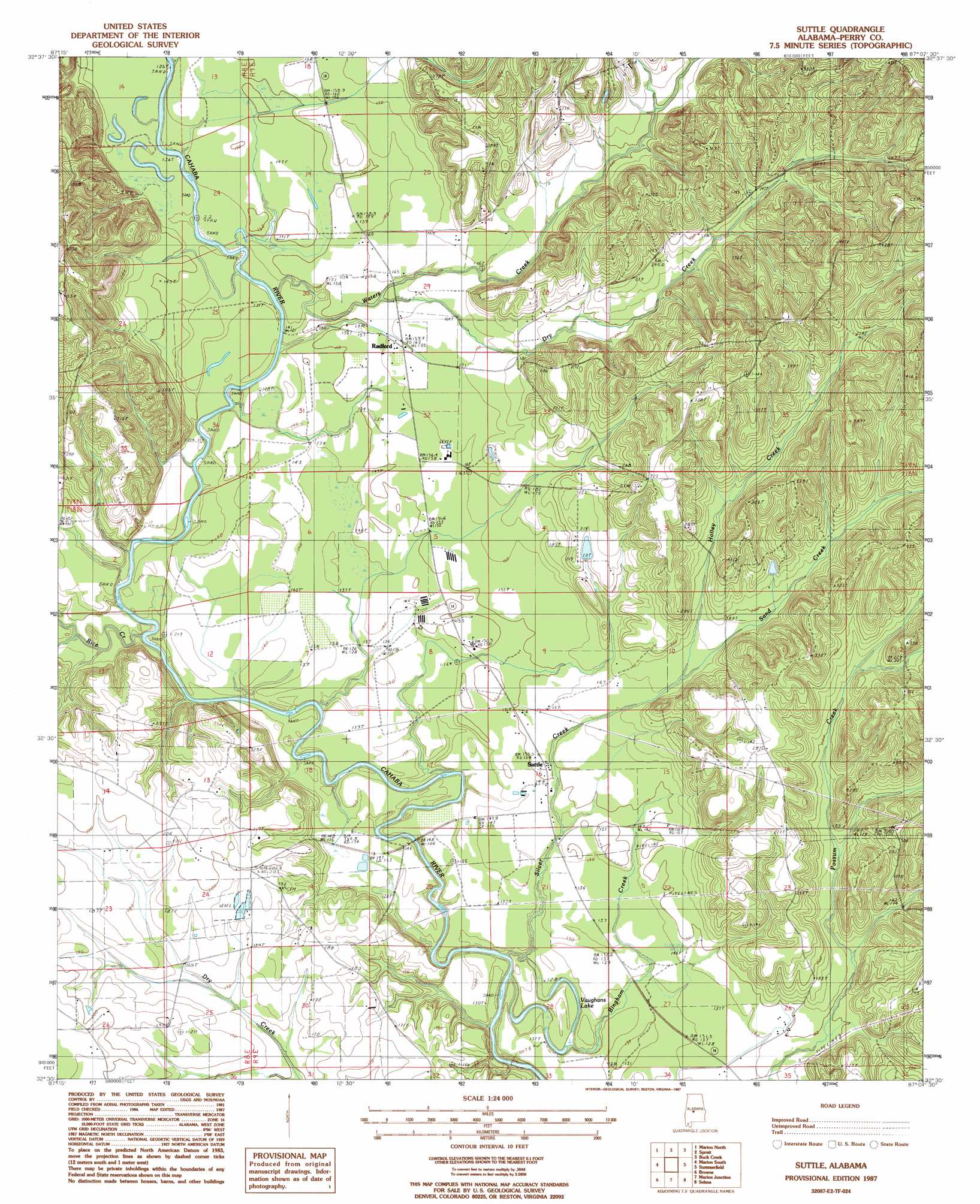
Suttle Topo Map Alabama
To zoom in, hover over the map of Suttle
USGS Topo Quad 32087e2 - 1:24,000 scale
| Topo Map Name: | Suttle |
| USGS Topo Quad ID: | 32087e2 |
| Print Size: | ca. 21 1/4" wide x 27" high |
| Southeast Coordinates: | 32.5° N latitude / 87.125° W longitude |
| Map Center Coordinates: | 32.5625° N latitude / 87.1875° W longitude |
| U.S. State: | AL |
| Filename: | o32087e2.jpg |
| Download Map JPG Image: | Suttle topo map 1:24,000 scale |
| Map Type: | Topographic |
| Topo Series: | 7.5´ |
| Map Scale: | 1:24,000 |
| Source of Map Images: | United States Geological Survey (USGS) |
| Alternate Map Versions: |
Summerfield SW AL 1975, updated 1977 Download PDF Buy paper map Suttle AL 1987, updated 1987 Download PDF Buy paper map Suttle AL 2011 Download PDF Buy paper map Suttle AL 2014 Download PDF Buy paper map |
1:24,000 Topo Quads surrounding Suttle
Hogglesville |
Heiberger |
Harrisburg |
Oakmulgee |
Maplesville West |
Morgan Springs |
Marion North |
Sprott |
Buck Creek |
Plantersville |
Scott Station |
Marion South |
Suttle |
Summerfield |
Jones |
Uniontown East |
Browns |
Marion Junction |
Selma |
Burnsville |
Central Mills |
Safford |
Orrville |
Blackwell Bend |
Sardis |
> Back to 32087e1 at 1:100,000 scale
> Back to 32086a1 at 1:250,000 scale
> Back to U.S. Topo Maps home
Suttle topo map: Gazetteer
Suttle: Dams
Lakeland Farms Dam Number Nineteen elevation 107m 351′Suttle: Lakes
Vaughans Lake elevation 33m 108′Suttle: Populated Places
Radford elevation 49m 160′Suttle elevation 45m 147′
Suttle: Post Offices
Suttle Post Office elevation 46m 150′Suttle: Reservoirs
Lakeland Farms Pond Number Nineteen elevation 107m 351′Suttle: Streams
Bingham Creek elevation 33m 108′Dry Creek elevation 46m 150′
Holley Creek elevation 54m 177′
Rice Creek elevation 37m 121′
Sand Creek elevation 54m 177′
Silver Creek elevation 36m 118′
Waters Creek elevation 39m 127′
Wells Creek elevation 43m 141′
Suttle digital topo map on disk
Buy this Suttle topo map showing relief, roads, GPS coordinates and other geographical features, as a high-resolution digital map file on DVD:
Gulf Coast (LA, MS, AL, FL) & Southwestern Georgia
Buy digital topo maps: Gulf Coast (LA, MS, AL, FL) & Southwestern Georgia
 & Southwestern Georgia map DVD")