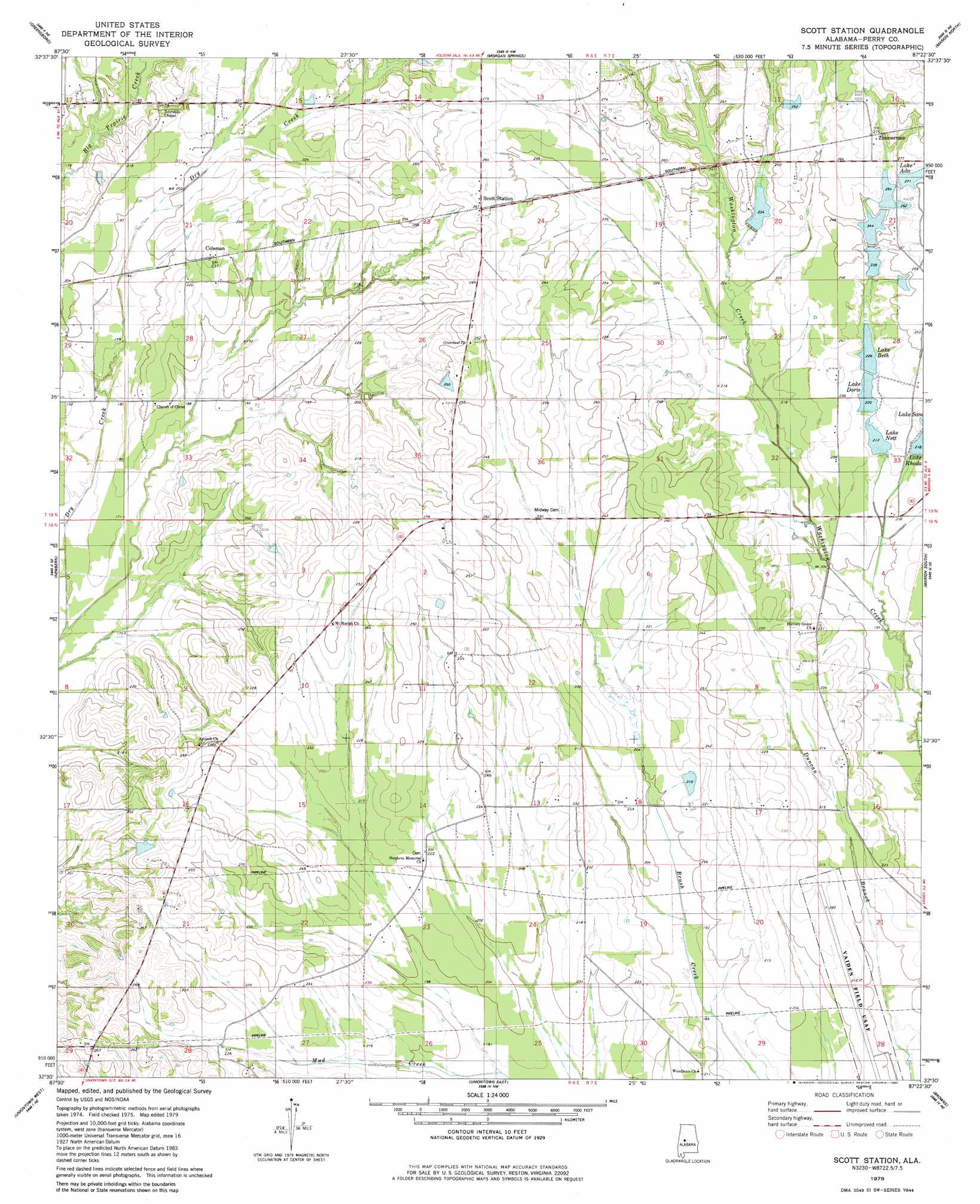
Scott Station Topo Map Alabama
To zoom in, hover over the map of Scott Station
USGS Topo Quad 32087e4 - 1:24,000 scale
| Topo Map Name: | Scott Station |
| USGS Topo Quad ID: | 32087e4 |
| Print Size: | ca. 21 1/4" wide x 27" high |
| Southeast Coordinates: | 32.5° N latitude / 87.375° W longitude |
| Map Center Coordinates: | 32.5625° N latitude / 87.4375° W longitude |
| U.S. State: | AL |
| Filename: | o32087e4.jpg |
| Download Map JPG Image: | Scott Station topo map 1:24,000 scale |
| Map Type: | Topographic |
| Topo Series: | 7.5´ |
| Map Scale: | 1:24,000 |
| Source of Map Images: | United States Geological Survey (USGS) |
| Alternate Map Versions: |
Scott Station AL 1979, updated 1980 Download PDF Buy paper map Scott Station AL 2011 Download PDF Buy paper map Scott Station AL 2014 Download PDF Buy paper map |
1:24,000 Topo Quads surrounding Scott Station
Sawyerville |
Ingram |
Hogglesville |
Heiberger |
Harrisburg |
Melton |
Greensboro |
Morgan Springs |
Marion North |
Sprott |
Casemore |
Newbern |
Scott Station |
Marion South |
Suttle |
Gallion |
Uniontown West |
Uniontown East |
Browns |
Marion Junction |
Thomaston West |
Thomaston East |
Central Mills |
Safford |
Orrville |
> Back to 32087e1 at 1:100,000 scale
> Back to 32086a1 at 1:250,000 scale
> Back to U.S. Topo Maps home
Scott Station topo map: Gazetteer
Scott Station: Airports
Vaiden Field elevation 64m 209′Scott Station: Areas
Scotts Prairie elevation 81m 265′Walkers Prairie elevation 70m 229′
Scott Station: Dams
Bone Lake Dam elevation 80m 262′Hilton Mckee Lake Dam elevation 78m 255′
James A Wheeler Lake Dam elevation 64m 209′
Joe Dozier Dam elevation 71m 232′
Lakeland Farms Dam Number Eight elevation 76m 249′
Lakeland Farms Dam Number Five elevation 67m 219′
Lakeland Farms Dam Number Four elevation 67m 219′
Lakeland Farms Dam Number Seven elevation 76m 249′
Lakeland Farms Dam Number Seventeen elevation 83m 272′
Lakeland Farms Dam Number Six elevation 72m 236′
Lakeland Farms Dam Number Three elevation 67m 219′
Lakeland Farms Dam Number Two elevation 68m 223′
Marguerite S Howell Lake Dam elevation 62m 203′
Scott Station: Populated Places
Coleman elevation 70m 229′Sugarville elevation 71m 232′
Zimmerman elevation 83m 272′
Scott Station: Reservoirs
Bone Lake elevation 80m 262′Hilton Mckee Lake elevation 78m 255′
James A Wheeler Lake elevation 64m 209′
Joe Dozier Lake elevation 71m 232′
Lake Ada elevation 83m 272′
Lake Beth elevation 69m 226′
Lake Doris elevation 67m 219′
Lake Nett elevation 65m 213′
Lake Rhoda elevation 67m 219′
Lakeland Farms Lake Number Eight elevation 76m 249′
Lakeland Farms Lake Number Seven elevation 76m 249′
Lakeland Farms Lake Number Six elevation 72m 236′
Marguerite S Howell Lake elevation 62m 203′
Scott Station: Streams
Piney Ridge Branch elevation 66m 216′Scott Station digital topo map on disk
Buy this Scott Station topo map showing relief, roads, GPS coordinates and other geographical features, as a high-resolution digital map file on DVD:
Gulf Coast (LA, MS, AL, FL) & Southwestern Georgia
Buy digital topo maps: Gulf Coast (LA, MS, AL, FL) & Southwestern Georgia
 & Southwestern Georgia map DVD")