Newbern Topo Map Alabama
To zoom in, hover over the map of Newbern
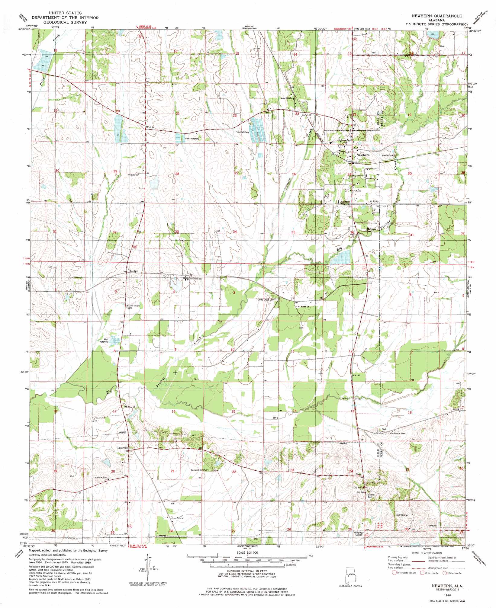
USGS Topo Quad 32087e5 - 1:24,000 scale
| Topo Map Name: | Newbern |
| USGS Topo Quad ID: | 32087e5 |
| Print Size: | ca. 21 1/4" wide x 27" high |
| Southeast Coordinates: | 32.5° N latitude / 87.5° W longitude |
| Map Center Coordinates: | 32.5625° N latitude / 87.5625° W longitude |
| U.S. State: | AL |
| Filename: | o32087e5.jpg |
| Download Map JPG Image: | Newbern topo map 1:24,000 scale |
| Map Type: | Topographic |
| Topo Series: | 7.5´ |
| Map Scale: | 1:24,000 |
| Source of Map Images: | United States Geological Survey (USGS) |
| Alternate Map Versions: |
Newbern AL 1980, updated 1980 Download PDF Buy paper map Newbern AL 2011 Download PDF Buy paper map Newbern AL 2014 Download PDF Buy paper map |
1:24,000 Topo Quads surrounding Newbern
Warrior Dam |
Sawyerville |
Ingram |
Hogglesville |
Heiberger |
Mason Bend |
Melton |
Greensboro |
Morgan Springs |
Marion North |
Demopolis |
Casemore |
Newbern |
Scott Station |
Marion South |
Old Spring Hill |
Gallion |
Uniontown West |
Uniontown East |
Browns |
Linden |
Thomaston West |
Thomaston East |
Central Mills |
Safford |
> Back to 32087e1 at 1:100,000 scale
> Back to 32086a1 at 1:250,000 scale
> Back to U.S. Topo Maps home
Newbern topo map: Gazetteer
Newbern: Dams
B W Coleman Farm Dam Number 1 elevation 49m 160′B W Coleman Farm Dam Number 2 elevation 49m 160′
Cottrell Lake Dam elevation 69m 226′
Jack Hardenbergh Dam elevation 61m 200′
Kyser Lakes Dam Number 4 elevation 41m 134′
Kyser Lakes Dam Number 5 elevation 44m 144′
Kyser Lakes Dam Number 6 elevation 43m 141′
Walthall Lake Dam elevation 41m 134′
William Dale Dam elevation 51m 167′
Willie Woods Dam Number 1 elevation 42m 137′
Willie Woods Dam Number 2 elevation 40m 131′
Willie Woods Dam Number 3 elevation 41m 134′
Newbern: Parks
Frank Watford Stadium elevation 46m 150′Newbern: Populated Places
Laneville elevation 58m 190′Newbern elevation 57m 187′
Sunshine elevation 56m 183′
Whitsitt elevation 62m 203′
Newbern: Post Offices
Newbern Post Office elevation 62m 203′Newbern: Reservoirs
Coleman Farm Ponds elevation 49m 160′Coleman Farm Ponds elevation 49m 160′
Cottrell Lake elevation 69m 226′
Hardenbergh Lake elevation 61m 200′
Kyser Lakes elevation 41m 134′
Kyser Lakes elevation 44m 144′
Kyser Lakes elevation 43m 141′
Walthall Lake elevation 41m 134′
Watershed Structure Number Eleven elevation 62m 203′
William Dale Lake elevation 51m 167′
Willie Woods Lake elevation 41m 134′
Willie Woods Lake elevation 40m 131′
Willie Woods Lake elevation 42m 137′
Newbern: Streams
Dry Creek elevation 34m 111′Jollywell Branch elevation 40m 131′
Posey Branch elevation 34m 111′
Whitsitt Creek elevation 40m 131′
Newbern digital topo map on disk
Buy this Newbern topo map showing relief, roads, GPS coordinates and other geographical features, as a high-resolution digital map file on DVD:
Gulf Coast (LA, MS, AL, FL) & Southwestern Georgia
Buy digital topo maps: Gulf Coast (LA, MS, AL, FL) & Southwestern Georgia
 & Southwestern Georgia map DVD")