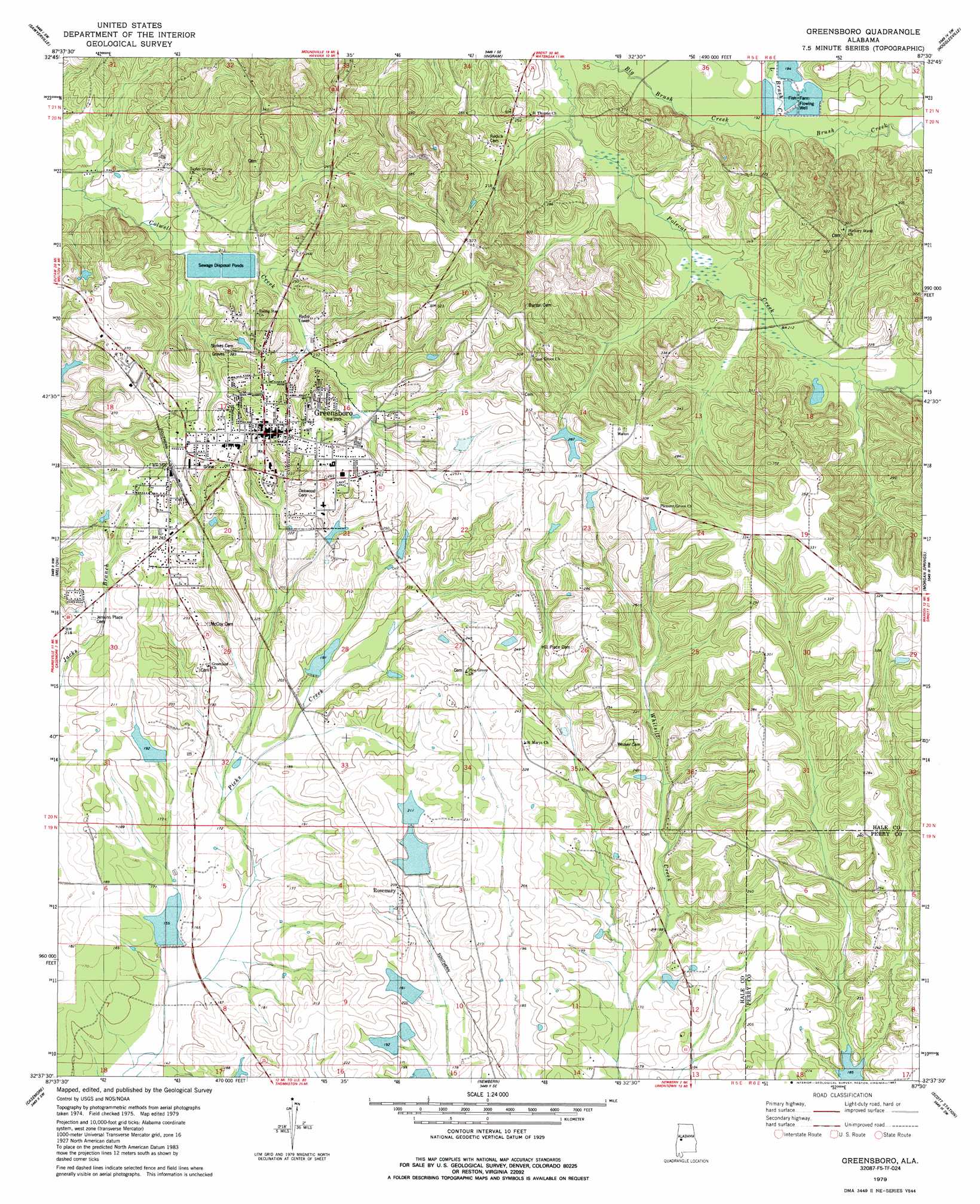
Greensboro Topo Map Alabama
To zoom in, hover over the map of Greensboro
USGS Topo Quad 32087f5 - 1:24,000 scale
| Topo Map Name: | Greensboro |
| USGS Topo Quad ID: | 32087f5 |
| Print Size: | ca. 21 1/4" wide x 27" high |
| Southeast Coordinates: | 32.625° N latitude / 87.5° W longitude |
| Map Center Coordinates: | 32.6875° N latitude / 87.5625° W longitude |
| U.S. State: | AL |
| Filename: | o32087f5.jpg |
| Download Map JPG Image: | Greensboro topo map 1:24,000 scale |
| Map Type: | Topographic |
| Topo Series: | 7.5´ |
| Map Scale: | 1:24,000 |
| Source of Map Images: | United States Geological Survey (USGS) |
| Alternate Map Versions: |
Greensboro AL 1979, updated 1980 Download PDF Buy paper map Greensboro AL 2011 Download PDF Buy paper map Greensboro AL 2014 Download PDF Buy paper map |
1:24,000 Topo Quads surrounding Greensboro
Knoxville |
Moundville West |
Moundville East |
Payne Lake |
Pondville |
Warrior Dam |
Sawyerville |
Ingram |
Hogglesville |
Heiberger |
Mason Bend |
Melton |
Greensboro |
Morgan Springs |
Marion North |
Demopolis |
Casemore |
Newbern |
Scott Station |
Marion South |
Old Spring Hill |
Gallion |
Uniontown West |
Uniontown East |
Browns |
> Back to 32087e1 at 1:100,000 scale
> Back to 32086a1 at 1:250,000 scale
> Back to U.S. Topo Maps home
Greensboro topo map: Gazetteer
Greensboro: Dams
Carmichael Lake Dam elevation 47m 154′Gross Lake Dam elevation 58m 190′
J L Morrison Dam Number 1 elevation 61m 200′
J L Morrison Dam Number 2 elevation 85m 278′
Kyser Lakes Dam Number 1 elevation 59m 193′
Kyser Lakes Dam Number 2 elevation 64m 209′
Kyser Lakes Dam Number 7 elevation 54m 177′
Lenson Montz Dam Number 1 elevation 59m 193′
Lenson Montz Dam Number 2 elevation 59m 193′
Lenson Montz Dam Number 3 elevation 59m 193′
Lenson Montz Dam Number 4 elevation 59m 193′
Lewis Lawson Dam Number 4 elevation 58m 190′
Lewis Lawson Dam Number 5 elevation 62m 203′
Morrison Brothers Dam elevation 61m 200′
Greensboro: Parks
Greensboro Historic District elevation 86m 282′Lions Park elevation 75m 246′
Greensboro: Populated Places
Greensboro elevation 86m 282′Rosemary elevation 64m 209′
Greensboro: Post Offices
Greensboro Post Office elevation 84m 275′Greensboro: Reservoirs
Carmichael Lake elevation 47m 154′Gross Lake elevation 58m 190′
J L Morrison Lake Number One elevation 61m 200′
J L Morrison Lake Number Two elevation 85m 278′
Kyser Lakes elevation 54m 177′
Kyser Lakes elevation 64m 209′
Kyser Lakes elevation 59m 193′
Lenson Montz Ponds elevation 59m 193′
Lenson Montz Ponds elevation 59m 193′
Lenson Montz Ponds elevation 59m 193′
Lewis Lawson Lake Number Five elevation 62m 203′
Lewis Lawson Lake Number Four elevation 58m 190′
Montz Lake Number Four elevation 59m 193′
Morrison Brothers Lake elevation 61m 200′
Greensboro: Streams
Bills Branch elevation 60m 196′Brush Creek elevation 59m 193′
Little Brush Creek elevation 59m 193′
Greensboro digital topo map on disk
Buy this Greensboro topo map showing relief, roads, GPS coordinates and other geographical features, as a high-resolution digital map file on DVD:
Gulf Coast (LA, MS, AL, FL) & Southwestern Georgia
Buy digital topo maps: Gulf Coast (LA, MS, AL, FL) & Southwestern Georgia
 & Southwestern Georgia map DVD")