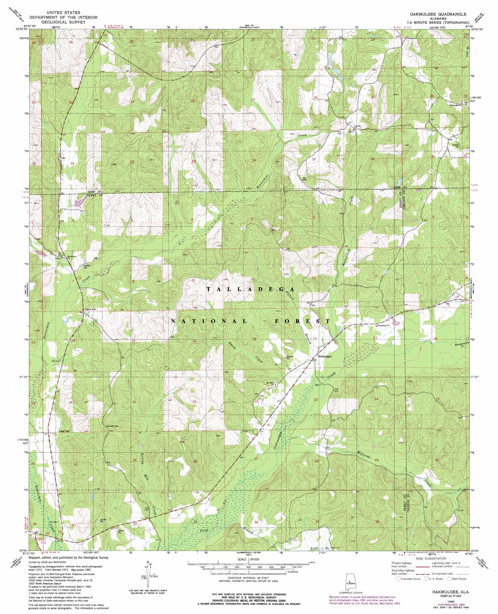
Oakmulgee Topo Map Alabama
To zoom in, hover over the map of Oakmulgee
USGS Topo Quad 32087g1 - 1:24,000 scale
| Topo Map Name: | Oakmulgee |
| USGS Topo Quad ID: | 32087g1 |
| Print Size: | ca. 21 1/4" wide x 27" high |
| Southeast Coordinates: | 32.75° N latitude / 87° W longitude |
| Map Center Coordinates: | 32.8125° N latitude / 87.0625° W longitude |
| U.S. State: | AL |
| Filename: | o32087g1.jpg |
| Download Map JPG Image: | Oakmulgee topo map 1:24,000 scale |
| Map Type: | Topographic |
| Topo Series: | 7.5´ |
| Map Scale: | 1:24,000 |
| Source of Map Images: | United States Geological Survey (USGS) |
| Alternate Map Versions: |
Oakmulgee AL 1980, updated 1980 Download PDF Buy paper map Oakmulgee AL 1980, updated 1985 Download PDF Buy paper map Oakmulgee AL 2002, updated 2003 Download PDF Buy paper map Oakmulgee AL 2011 Download PDF Buy paper map Oakmulgee AL 2014 Download PDF Buy paper map |
| FStopo: | US Forest Service topo Oakmulgee is available: Download FStopo PDF Download FStopo TIF |
1:24,000 Topo Quads surrounding Oakmulgee
Pearson |
West Blocton West |
West Blocton East |
Aldrich |
Montevallo |
Pondville |
Centreville West |
Centreville East |
Randolph |
Jemison West |
Heiberger |
Harrisburg |
Oakmulgee |
Maplesville West |
Maplesville East |
Marion North |
Sprott |
Buck Creek |
Plantersville |
Pletcher |
Marion South |
Suttle |
Summerfield |
Jones |
Milton |
> Back to 32087e1 at 1:100,000 scale
> Back to 32086a1 at 1:250,000 scale
> Back to U.S. Topo Maps home
Oakmulgee topo map: Gazetteer
Oakmulgee: Populated Places
Bethlehem elevation 120m 393′Oakmulgee elevation 98m 321′
Pinetucky elevation 99m 324′
Tabernacle elevation 179m 587′
Oakmulgee: Post Offices
Oakmulgee Post Office (historical) elevation 114m 374′Oakmulgee: Streams
Boiling Mill Creek elevation 83m 272′Camp Branch elevation 120m 393′
Dutch Creek elevation 94m 308′
Frith Branch elevation 82m 269′
Holsombech Creek elevation 94m 308′
Honeysuckle Creek elevation 100m 328′
Pickett Branch elevation 93m 305′
Undermine Creek elevation 122m 400′
Williams Creek elevation 90m 295′
Oakmulgee: Summits
Bull Mountain elevation 183m 600′Oakmulgee digital topo map on disk
Buy this Oakmulgee topo map showing relief, roads, GPS coordinates and other geographical features, as a high-resolution digital map file on DVD:
Gulf Coast (LA, MS, AL, FL) & Southwestern Georgia
Buy digital topo maps: Gulf Coast (LA, MS, AL, FL) & Southwestern Georgia
 & Southwestern Georgia map DVD")