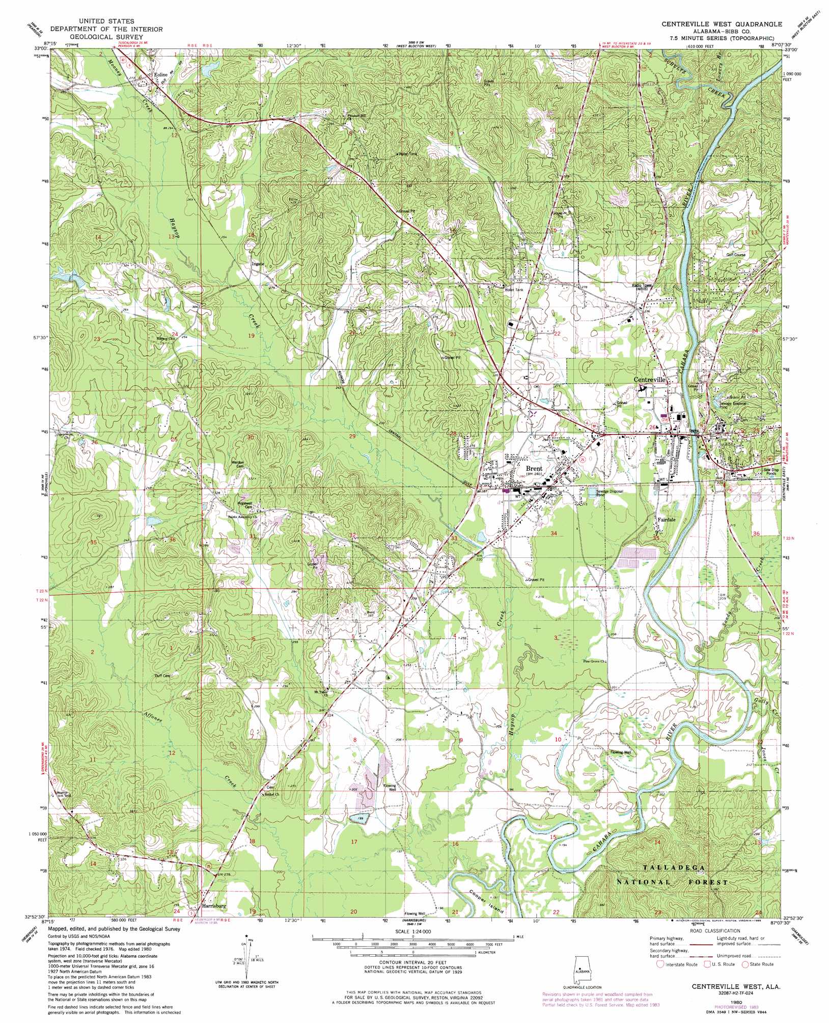
Centreville West Topo Map Alabama
To zoom in, hover over the map of Centreville West
USGS Topo Quad 32087h2 - 1:24,000 scale
| Topo Map Name: | Centreville West |
| USGS Topo Quad ID: | 32087h2 |
| Print Size: | ca. 21 1/4" wide x 27" high |
| Southeast Coordinates: | 32.875° N latitude / 87.125° W longitude |
| Map Center Coordinates: | 32.9375° N latitude / 87.1875° W longitude |
| U.S. State: | AL |
| Filename: | o32087h2.jpg |
| Download Map JPG Image: | Centreville West topo map 1:24,000 scale |
| Map Type: | Topographic |
| Topo Series: | 7.5´ |
| Map Scale: | 1:24,000 |
| Source of Map Images: | United States Geological Survey (USGS) |
| Alternate Map Versions: |
Centreville West AL 1980, updated 1980 Download PDF Buy paper map Centreville West AL 1980, updated 1985 Download PDF Buy paper map Centreville West AL 2002, updated 2004 Download PDF Buy paper map Centreville West AL 2011 Download PDF Buy paper map Centreville West AL 2014 Download PDF Buy paper map |
| FStopo: | US Forest Service topo Centreville West is available: Download FStopo PDF Download FStopo TIF |
1:24,000 Topo Quads surrounding Centreville West
Cottondale |
Coaling |
Woodstock |
Halfmile Shoals |
Pea Ridge |
Duncanville |
Pearson |
West Blocton West |
West Blocton East |
Aldrich |
Payne Lake |
Pondville |
Centreville West |
Centreville East |
Randolph |
Hogglesville |
Heiberger |
Harrisburg |
Oakmulgee |
Maplesville West |
Morgan Springs |
Marion North |
Sprott |
Buck Creek |
Plantersville |
> Back to 32087e1 at 1:100,000 scale
> Back to 32086a1 at 1:250,000 scale
> Back to U.S. Topo Maps home
Centreville West topo map: Gazetteer
Centreville West: Bridges
Howard Cooper Bridge elevation 60m 196′Centreville West: Crossings
Centreville Ferry (historical) elevation 60m 196′Youngbloods Ferry (historical) elevation 59m 193′
Centreville West: Flats
Goodson Bottoms elevation 60m 196′Centreville West: Islands
Cooper Island elevation 58m 190′Centreville West: Lakes
Avery Pond (historical) elevation 79m 259′Centreville West: Populated Places
Brent elevation 73m 239′Centreville elevation 77m 252′
Choctaw Hills elevation 124m 406′
Duff Settlement elevation 111m 364′
East Centreville elevation 82m 269′
East Town elevation 96m 314′
Eoline elevation 84m 275′
Fairdale elevation 68m 223′
Goodson elevation 81m 265′
Harrisburg elevation 70m 229′
Ingate elevation 80m 262′
Jamesville elevation 81m 265′
Penootaw (historical) elevation 84m 275′
Pleasant Hill elevation 114m 374′
Spencer elevation 89m 291′
West Centreville elevation 67m 219′
Zulu elevation 68m 223′
Centreville West: Post Offices
Brent Post Office elevation 75m 246′Centreville Post Office elevation 90m 295′
Centreville West: Streams
Bill Branch elevation 66m 216′Congo Creek elevation 60m 196′
Cooper Pasture Branch elevation 60m 196′
Dry Hollow Branch elevation 59m 193′
Gully Creek elevation 60m 196′
Haysop Creek elevation 54m 177′
Horse Branch elevation 83m 272′
Jones Creek elevation 59m 193′
Lowery Branch elevation 66m 216′
Mooney Creek elevation 75m 246′
Sandy Creek elevation 58m 190′
Schultz Creek elevation 60m 196′
Smith Creek elevation 58m 190′
Centreville West digital topo map on disk
Buy this Centreville West topo map showing relief, roads, GPS coordinates and other geographical features, as a high-resolution digital map file on DVD:
Gulf Coast (LA, MS, AL, FL) & Southwestern Georgia
Buy digital topo maps: Gulf Coast (LA, MS, AL, FL) & Southwestern Georgia
 & Southwestern Georgia map DVD")