Knoxville Topo Map Alabama
To zoom in, hover over the map of Knoxville
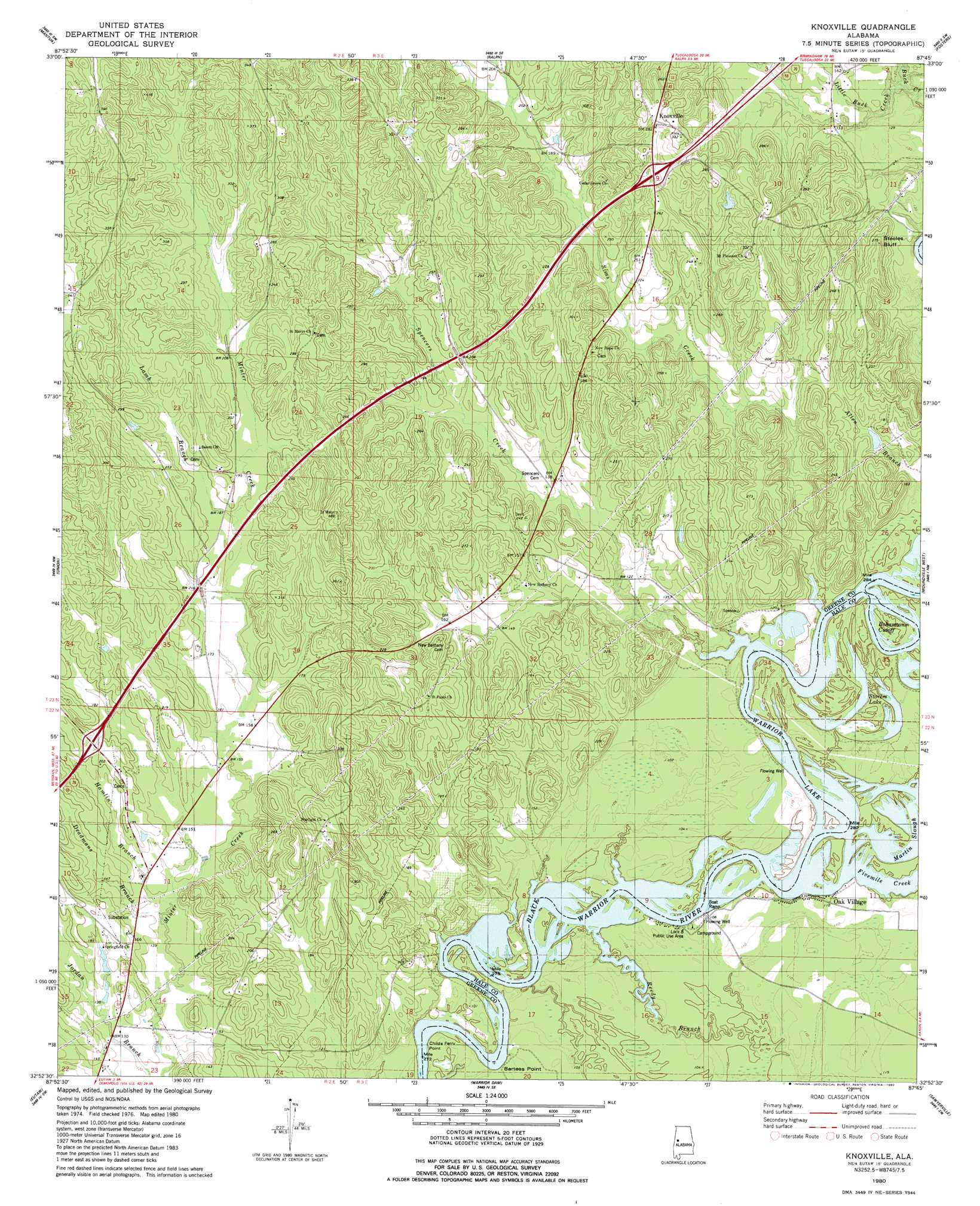
USGS Topo Quad 32087h7 - 1:24,000 scale
| Topo Map Name: | Knoxville |
| USGS Topo Quad ID: | 32087h7 |
| Print Size: | ca. 21 1/4" wide x 27" high |
| Southeast Coordinates: | 32.875° N latitude / 87.75° W longitude |
| Map Center Coordinates: | 32.9375° N latitude / 87.8125° W longitude |
| U.S. State: | AL |
| Filename: | o32087h7.jpg |
| Download Map JPG Image: | Knoxville topo map 1:24,000 scale |
| Map Type: | Topographic |
| Topo Series: | 7.5´ |
| Map Scale: | 1:24,000 |
| Source of Map Images: | United States Geological Survey (USGS) |
| Alternate Map Versions: |
Knoxville AL 1980, updated 1980 Download PDF Buy paper map Knoxville AL 2011 Download PDF Buy paper map Knoxville AL 2014 Download PDF Buy paper map |
1:24,000 Topo Quads surrounding Knoxville
Cunningham |
Kirk |
Romulus |
Coker |
Tuscaloosa |
Pleasant Ridge |
Mantua |
Ralph |
Fosters |
Englewood |
West Greene |
Union |
Knoxville |
Moundville West |
Moundville East |
Boligee |
Eutaw |
Warrior Dam |
Sawyerville |
Ingram |
Epes East |
Forkland |
Mason Bend |
Melton |
Greensboro |
> Back to 32087e1 at 1:100,000 scale
> Back to 32086a1 at 1:250,000 scale
> Back to U.S. Topo Maps home
Knoxville topo map: Gazetteer
Knoxville: Bars
Bartees Bar elevation 29m 95′Brodnax Bar elevation 29m 95′
Chiles Ferry Bar elevation 29m 95′
Hickmans Bar elevation 29m 95′
Long Bend Shoal elevation 29m 95′
Merriweather Reef elevation 30m 98′
Merriweathers Bar elevation 29m 95′
Morrow Rock elevation 30m 98′
Z Loggans Bar elevation 31m 101′
Knoxville: Bends
Bohannons Cutoff elevation 31m 101′Long Bend elevation 30m 98′
Knoxville: Capes
Bartees Point elevation 31m 101′Childs Ferry Point elevation 31m 101′
Knoxville: Cliffs
Eagle Bluff elevation 31m 101′Logan Bluff elevation 31m 101′
Steeles Bluff elevation 55m 180′
Steeles Bluff elevation 77m 252′
Wilson Bluff elevation 32m 104′
Knoxville: Crossings
Chiles Ferry (historical) elevation 29m 95′Exit 45 elevation 66m 216′
Exit 52 elevation 76m 249′
Knoxville: Guts
Martin Slough elevation 29m 95′Knoxville: Islands
Colvins Island elevation 31m 101′Jones Field elevation 31m 101′
Wildmans Island elevation 30m 98′
Knoxville: Lakes
Storers Lake elevation 29m 95′Stovers Lake elevation 29m 95′
Knoxville: Parks
Lock Eight Public Use Area elevation 32m 104′Knoxville: Populated Places
Knoxville elevation 88m 288′Oak Village elevation 31m 101′
Knoxville: Streams
Deadmans Branch elevation 36m 118′Fivemile Creek elevation 29m 95′
Hamlin Branch elevation 37m 121′
Lamb Branch elevation 55m 180′
Little Buck Creek elevation 36m 118′
Reedy Branch elevation 29m 95′
Sims Creek elevation 30m 98′
Spencers Creek elevation 29m 95′
Knoxville digital topo map on disk
Buy this Knoxville topo map showing relief, roads, GPS coordinates and other geographical features, as a high-resolution digital map file on DVD:
Gulf Coast (LA, MS, AL, FL) & Southwestern Georgia
Buy digital topo maps: Gulf Coast (LA, MS, AL, FL) & Southwestern Georgia
 & Southwestern Georgia map DVD")