Putnam Topo Map Alabama
To zoom in, hover over the map of Putnam
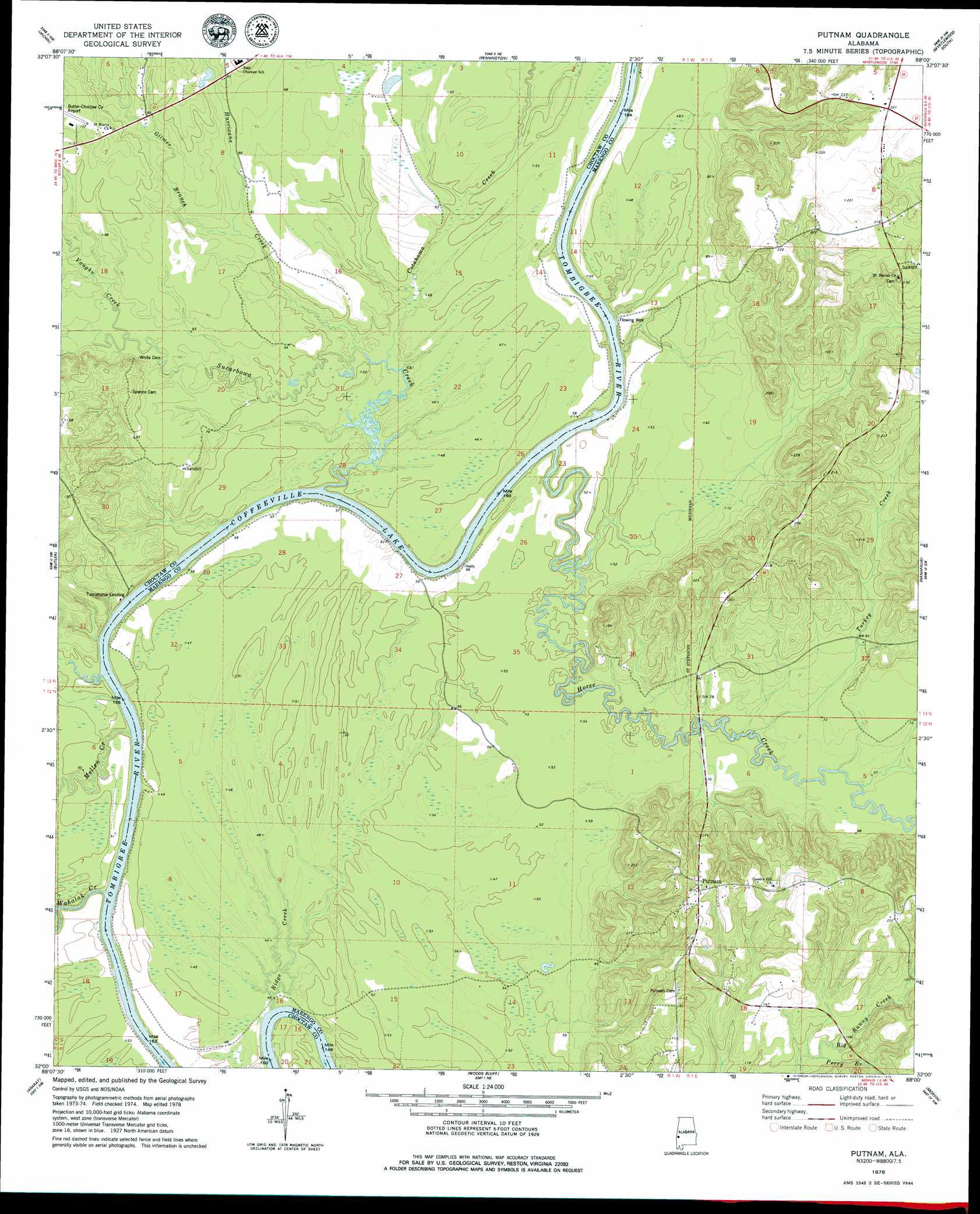
USGS Topo Quad 32088a1 - 1:24,000 scale
| Topo Map Name: | Putnam |
| USGS Topo Quad ID: | 32088a1 |
| Print Size: | ca. 21 1/4" wide x 27" high |
| Southeast Coordinates: | 32° N latitude / 88° W longitude |
| Map Center Coordinates: | 32.0625° N latitude / 88.0625° W longitude |
| U.S. State: | AL |
| Filename: | o32088a1.jpg |
| Download Map JPG Image: | Putnam topo map 1:24,000 scale |
| Map Type: | Topographic |
| Topo Series: | 7.5´ |
| Map Scale: | 1:24,000 |
| Source of Map Images: | United States Geological Survey (USGS) |
| Alternate Map Versions: |
Putnam AL 1978, updated 1979 Download PDF Buy paper map Putnam AL 2011 Download PDF Buy paper map Putnam AL 2014 Download PDF Buy paper map |
1:24,000 Topo Quads surrounding Putnam
Ward |
Gaston |
Whitfield |
Myrtlewood North |
Linden |
Lisman |
Jachin |
Pennington |
Myrtlewood South |
Miller |
Land |
Butler |
Putnam |
Nanafalia |
Sweet Water |
Toxey |
Ararat |
Woods Bluff |
Morvin |
Bashi |
Silas |
Coffeeville Lock And Dam |
Coffeeville |
Mcentyre |
Fulton West |
> Back to 32088a1 at 1:100,000 scale
> Back to 32088a1 at 1:250,000 scale
> Back to U.S. Topo Maps home
Putnam topo map: Gazetteer
Putnam: Bars
Pearsons Shoal elevation 10m 32′Putnam: Bends
Jacksons Bend elevation 11m 36′Putnam: Crossings
Gays Ferry (historical) elevation 14m 45′Putnam: Populated Places
Hornsboro (historical) elevation 64m 209′Putnam elevation 64m 209′
Putnam: Post Offices
Pineville Post Office (historical) elevation 58m 190′Putnam: Streams
Cotahoma Creek elevation 12m 39′Crooked Creek elevation 18m 59′
Gilmer Branch elevation 16m 52′
Horse Creek elevation 10m 32′
Hurricane Creek elevation 12m 39′
Mellen Creek elevation 12m 39′
Perry Branch elevation 27m 88′
Ridge Creek elevation 10m 32′
Sucarbowa Creek elevation 11m 36′
Sweetwater Creek elevation 12m 39′
Turkey Creek elevation 15m 49′
Vaughn Creek elevation 18m 59′
Wahalak Creek elevation 10m 32′
Putnam digital topo map on disk
Buy this Putnam topo map showing relief, roads, GPS coordinates and other geographical features, as a high-resolution digital map file on DVD:
Gulf Coast (LA, MS, AL, FL) & Southwestern Georgia
Buy digital topo maps: Gulf Coast (LA, MS, AL, FL) & Southwestern Georgia
 & Southwestern Georgia map DVD")