Yantley Topo Map Mississippi
To zoom in, hover over the map of Yantley
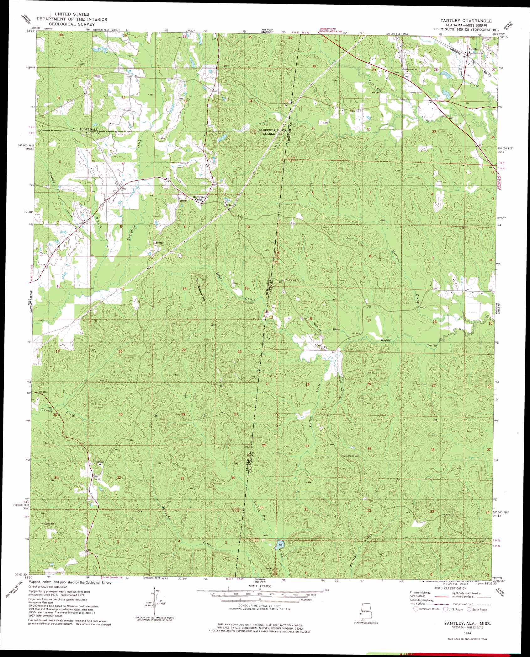
USGS Topo Quad 32088b4 - 1:24,000 scale
| Topo Map Name: | Yantley |
| USGS Topo Quad ID: | 32088b4 |
| Print Size: | ca. 21 1/4" wide x 27" high |
| Southeast Coordinates: | 32.125° N latitude / 88.375° W longitude |
| Map Center Coordinates: | 32.1875° N latitude / 88.4375° W longitude |
| U.S. States: | MS, AL |
| Filename: | o32088b4.jpg |
| Download Map JPG Image: | Yantley topo map 1:24,000 scale |
| Map Type: | Topographic |
| Topo Series: | 7.5´ |
| Map Scale: | 1:24,000 |
| Source of Map Images: | United States Geological Survey (USGS) |
| Alternate Map Versions: |
Yantley AL 1974, updated 1978 Download PDF Buy paper map Yantley AL 2011 Download PDF Buy paper map Yantley AL 2014 Download PDF Buy paper map |
1:24,000 Topo Quads surrounding Yantley
Meridian North |
Toomsuba |
Kewanee |
York |
Bellamy |
Meridian South |
Vimville |
Whynot |
Ward |
Gaston |
Sable |
Snell |
Yantley |
Lisman |
Jachin |
Quittman |
Sykes |
Hinton |
Land |
Butler |
De Soto |
Carmichael |
Melvin |
Toxey |
Ararat |
> Back to 32088a1 at 1:100,000 scale
> Back to 32088a1 at 1:250,000 scale
> Back to U.S. Topo Maps home
Yantley topo map: Gazetteer
Yantley: Canals
Douglas Canal elevation 80m 262′Yantley: Gaps
Rock Gap elevation 105m 344′Yantley: Populated Places
Cyril elevation 79m 259′Davidson (historical) elevation 124m 406′
Hurricane Creek elevation 134m 439′
Yantley elevation 85m 278′
Yantley: Ridges
Hog Wallow Ridge elevation 148m 485′Turkey Pen Ridge elevation 155m 508′
Yantley: Streams
Bowls Branch elevation 71m 232′Fuller Creek elevation 73m 239′
Goddin Creek elevation 112m 367′
Johnnie Branch elevation 106m 347′
Page Branch elevation 67m 219′
Williams Creek elevation 61m 200′
Williams Creek elevation 61m 200′
Yantley: Summits
Bill Mountain elevation 165m 541′Yantley digital topo map on disk
Buy this Yantley topo map showing relief, roads, GPS coordinates and other geographical features, as a high-resolution digital map file on DVD:
Gulf Coast (LA, MS, AL, FL) & Southwestern Georgia
Buy digital topo maps: Gulf Coast (LA, MS, AL, FL) & Southwestern Georgia
 & Southwestern Georgia map DVD")