Vimville Topo Map Mississippi
To zoom in, hover over the map of Vimville
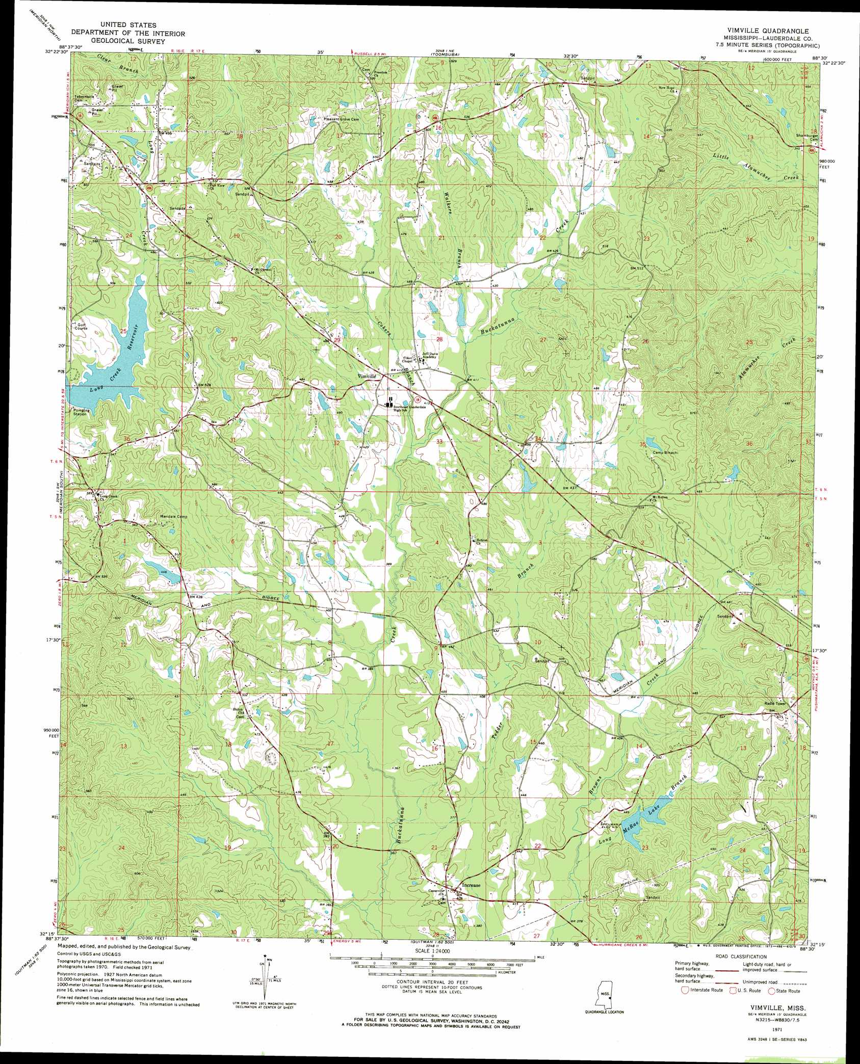
USGS Topo Quad 32088c5 - 1:24,000 scale
| Topo Map Name: | Vimville |
| USGS Topo Quad ID: | 32088c5 |
| Print Size: | ca. 21 1/4" wide x 27" high |
| Southeast Coordinates: | 32.25° N latitude / 88.5° W longitude |
| Map Center Coordinates: | 32.3125° N latitude / 88.5625° W longitude |
| U.S. State: | MS |
| Filename: | o32088c5.jpg |
| Download Map JPG Image: | Vimville topo map 1:24,000 scale |
| Map Type: | Topographic |
| Topo Series: | 7.5´ |
| Map Scale: | 1:24,000 |
| Source of Map Images: | United States Geological Survey (USGS) |
| Alternate Map Versions: |
Vimville MS 1971, updated 1973 Download PDF Buy paper map Vimville MS 2012 Download PDF Buy paper map Vimville MS 2015 Download PDF Buy paper map |
1:24,000 Topo Quads surrounding Vimville
Center Hill |
Daleville |
Lauderdale |
Tamola |
Boyd |
Collinsville |
Meridian North |
Toomsuba |
Kewanee |
York |
Meehan |
Meridian South |
Vimville |
Whynot |
Ward |
Stonewall |
Sable |
Snell |
Yantley |
Lisman |
Wautubbee |
Quittman |
Sykes |
Hinton |
Land |
> Back to 32088a1 at 1:100,000 scale
> Back to 32088a1 at 1:250,000 scale
> Back to U.S. Topo Maps home
Vimville topo map: Gazetteer
Vimville: Dams
Boy Scout Lake Dam elevation 157m 515′Boy Scout Lake Dam elevation 153m 501′
Carlyle Pond Dam elevation 151m 495′
D A Cook Pond Dam elevation 136m 446′
E M Carr Pond Dam elevation 126m 413′
J A Price Pond Dam elevation 134m 439′
J B McInnis Pond Dam elevation 134m 439′
L W Wilson Pond Dam elevation 128m 419′
Leland McInnis Castfish Pond Dam elevation 137m 449′
Long Creek Reservoir Dam elevation 134m 439′
Mae Hall Pond Dam elevation 125m 410′
Marble Pond Dam elevation 161m 528′
McDonald Pond Dam elevation 142m 465′
McRae Lake Dam elevation 128m 419′
Morris Covington Pond Dam elevation 122m 400′
Powell Catfish Ponds Dam elevation 158m 518′
Raymond Harper Pond Dam elevation 135m 442′
T E Tanner Pond Dam elevation 145m 475′
Vimville: Populated Places
Cliff Williams elevation 134m 439′Enzor elevation 170m 557′
Increase elevation 122m 400′
Vimville elevation 136m 446′
Vimville: Reservoirs
Long Creek Reservoir elevation 140m 459′McRae Lake elevation 122m 400′
Vimville: Streams
Cokers Branch elevation 119m 390′Long Branch elevation 116m 380′
Tedder Branch elevation 109m 357′
Walkers Branch elevation 122m 400′
Vimville digital topo map on disk
Buy this Vimville topo map showing relief, roads, GPS coordinates and other geographical features, as a high-resolution digital map file on DVD:
Gulf Coast (LA, MS, AL, FL) & Southwestern Georgia
Buy digital topo maps: Gulf Coast (LA, MS, AL, FL) & Southwestern Georgia
 & Southwestern Georgia map DVD")