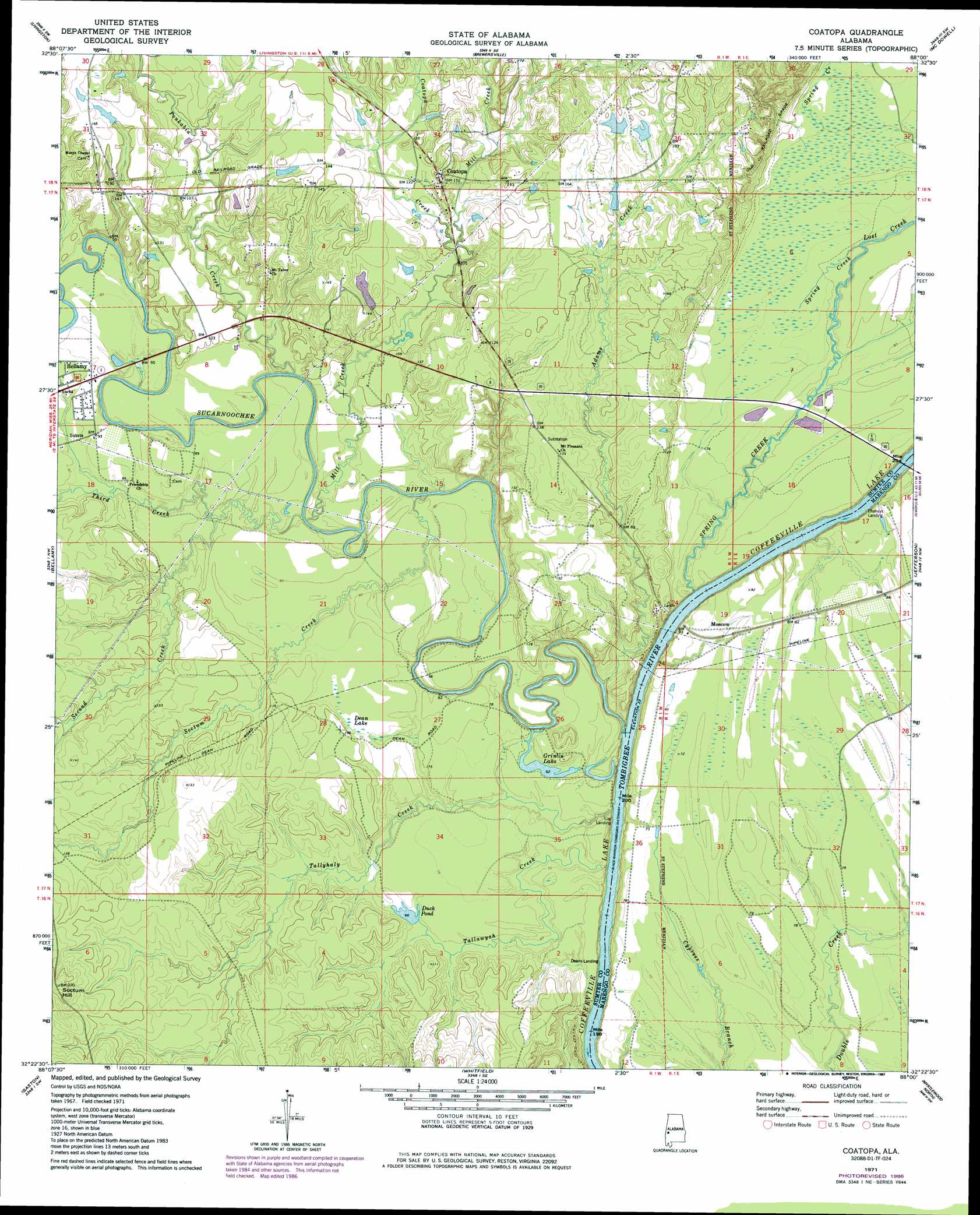
Coatopa Topo Map Alabama
To zoom in, hover over the map of Coatopa
USGS Topo Quad 32088d1 - 1:24,000 scale
| Topo Map Name: | Coatopa |
| USGS Topo Quad ID: | 32088d1 |
| Print Size: | ca. 21 1/4" wide x 27" high |
| Southeast Coordinates: | 32.375° N latitude / 88° W longitude |
| Map Center Coordinates: | 32.4375° N latitude / 88.0625° W longitude |
| U.S. State: | AL |
| Filename: | o32088d1.jpg |
| Download Map JPG Image: | Coatopa topo map 1:24,000 scale |
| Map Type: | Topographic |
| Topo Series: | 7.5´ |
| Map Scale: | 1:24,000 |
| Source of Map Images: | United States Geological Survey (USGS) |
| Alternate Map Versions: |
Coatopa AL 1971, updated 1974 Download PDF Buy paper map Coatopa AL 1971, updated 1984 Download PDF Buy paper map Coatopa AL 1971, updated 1987 Download PDF Buy paper map Coatopa AL 2011 Download PDF Buy paper map Coatopa AL 2014 Download PDF Buy paper map |
1:24,000 Topo Quads surrounding Coatopa
Emelle |
Epes West |
Epes East |
Forkland |
Mason Bend |
Boyd |
Livingston |
Brewersville |
Mcdowell |
Demopolis |
York |
Bellamy |
Coatopa |
Jefferson |
Old Spring Hill |
Ward |
Gaston |
Whitfield |
Myrtlewood North |
Linden |
Lisman |
Jachin |
Pennington |
Myrtlewood South |
Miller |
> Back to 32088a1 at 1:100,000 scale
> Back to 32088a1 at 1:250,000 scale
> Back to U.S. Topo Maps home
Coatopa topo map: Gazetteer
Coatopa: Bars
Indian Queen Bar elevation 11m 36′Coatopa: Bridges
Rooster Bridge elevation 10m 32′Coatopa: Crossings
Moscow Ferry (historical) elevation 10m 32′Coatopa: Dams
Mcgregor Dam elevation 31m 101′Coatopa: Lakes
Duck Pond elevation 20m 65′Coatopa: Populated Places
Arrington (historical) elevation 44m 144′Coatopa elevation 47m 154′
Coatopa: Post Offices
Coatopa Post Office elevation 47m 154′Coatopa: Reservoirs
Dean Lake elevation 25m 82′Grinlin Lake elevation 20m 65′
Mcgregor Lake elevation 31m 101′
Coatopa: Streams
Adams Creek elevation 12m 39′Coatopa Creek elevation 28m 91′
Lost Creek elevation 21m 68′
Mill Creek elevation 17m 55′
Ponkabia Creek elevation 17m 55′
Second Creek elevation 17m 55′
Soctum Creek elevation 17m 55′
Spring Creek elevation 13m 42′
Sucarnoochee River elevation 10m 32′
Tallawyah Creek elevation 15m 49′
Tallyhaly Creek elevation 11m 36′
Third Creek elevation 20m 65′
Coatopa: Summits
Soctum Hill elevation 68m 223′Coatopa digital topo map on disk
Buy this Coatopa topo map showing relief, roads, GPS coordinates and other geographical features, as a high-resolution digital map file on DVD:
Gulf Coast (LA, MS, AL, FL) & Southwestern Georgia
Buy digital topo maps: Gulf Coast (LA, MS, AL, FL) & Southwestern Georgia
 & Southwestern Georgia map DVD")