York Topo Map Alabama
To zoom in, hover over the map of York
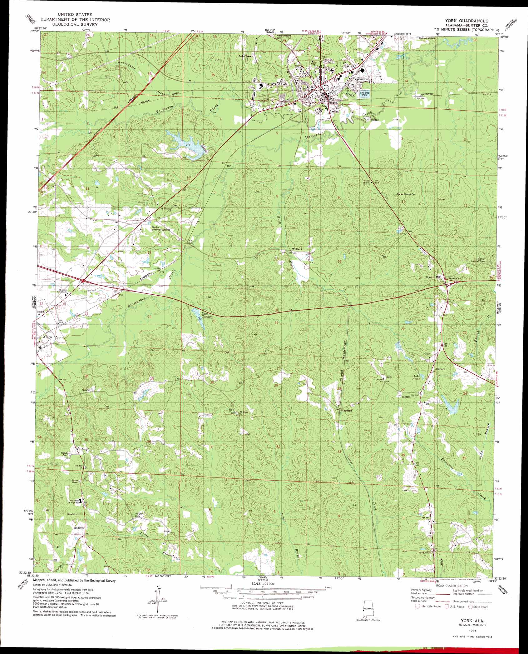
USGS Topo Quad 32088d3 - 1:24,000 scale
| Topo Map Name: | York |
| USGS Topo Quad ID: | 32088d3 |
| Print Size: | ca. 21 1/4" wide x 27" high |
| Southeast Coordinates: | 32.375° N latitude / 88.25° W longitude |
| Map Center Coordinates: | 32.4375° N latitude / 88.3125° W longitude |
| U.S. State: | AL |
| Filename: | o32088d3.jpg |
| Download Map JPG Image: | York topo map 1:24,000 scale |
| Map Type: | Topographic |
| Topo Series: | 7.5´ |
| Map Scale: | 1:24,000 |
| Source of Map Images: | United States Geological Survey (USGS) |
| Alternate Map Versions: |
York AL 1974, updated 1978 Download PDF Buy paper map York AL 2011 Download PDF Buy paper map York AL 2014 Download PDF Buy paper map |
1:24,000 Topo Quads surrounding York
Oak Grove |
Porterville |
Emelle |
Epes West |
Epes East |
Lauderdale |
Tamola |
Boyd |
Livingston |
Brewersville |
Toomsuba |
Kewanee |
York |
Bellamy |
Coatopa |
Vimville |
Whynot |
Ward |
Gaston |
Whitfield |
Snell |
Yantley |
Lisman |
Jachin |
Pennington |
> Back to 32088a1 at 1:100,000 scale
> Back to 32088a1 at 1:250,000 scale
> Back to U.S. Topo Maps home
York topo map: Gazetteer
York: Airports
Mallard Airport elevation 43m 141′York: Dams
Carolyn Dam elevation 62m 203′F N Grant Dam elevation 87m 285′
F N Grant Dam elevation 88m 288′
Lake Louise Dam elevation 68m 223′
York: Lakes
Lake Annie elevation 96m 314′York: Parks
Wildcat Stadium elevation 49m 160′York: Populated Places
Scratch Hill elevation 106m 347′Siloam elevation 103m 337′
Standard elevation 87m 285′
Williams elevation 57m 187′
York elevation 52m 170′
York: Post Offices
York Post Office elevation 53m 173′York: Reservoirs
F N Grant Lake elevation 88m 288′Grant Lake elevation 87m 285′
Lake Carolyn elevation 63m 206′
Lake Louise elevation 68m 223′
York: Streams
Buck Creek elevation 43m 141′Detain Branch elevation 65m 213′
Sweetwater Creek elevation 48m 157′
Toomsuba Creek elevation 43m 141′
Wiley Branch elevation 68m 223′
York: Summits
Alamuchee Hill elevation 116m 380′York digital topo map on disk
Buy this York topo map showing relief, roads, GPS coordinates and other geographical features, as a high-resolution digital map file on DVD:
Gulf Coast (LA, MS, AL, FL) & Southwestern Georgia
Buy digital topo maps: Gulf Coast (LA, MS, AL, FL) & Southwestern Georgia
 & Southwestern Georgia map DVD")