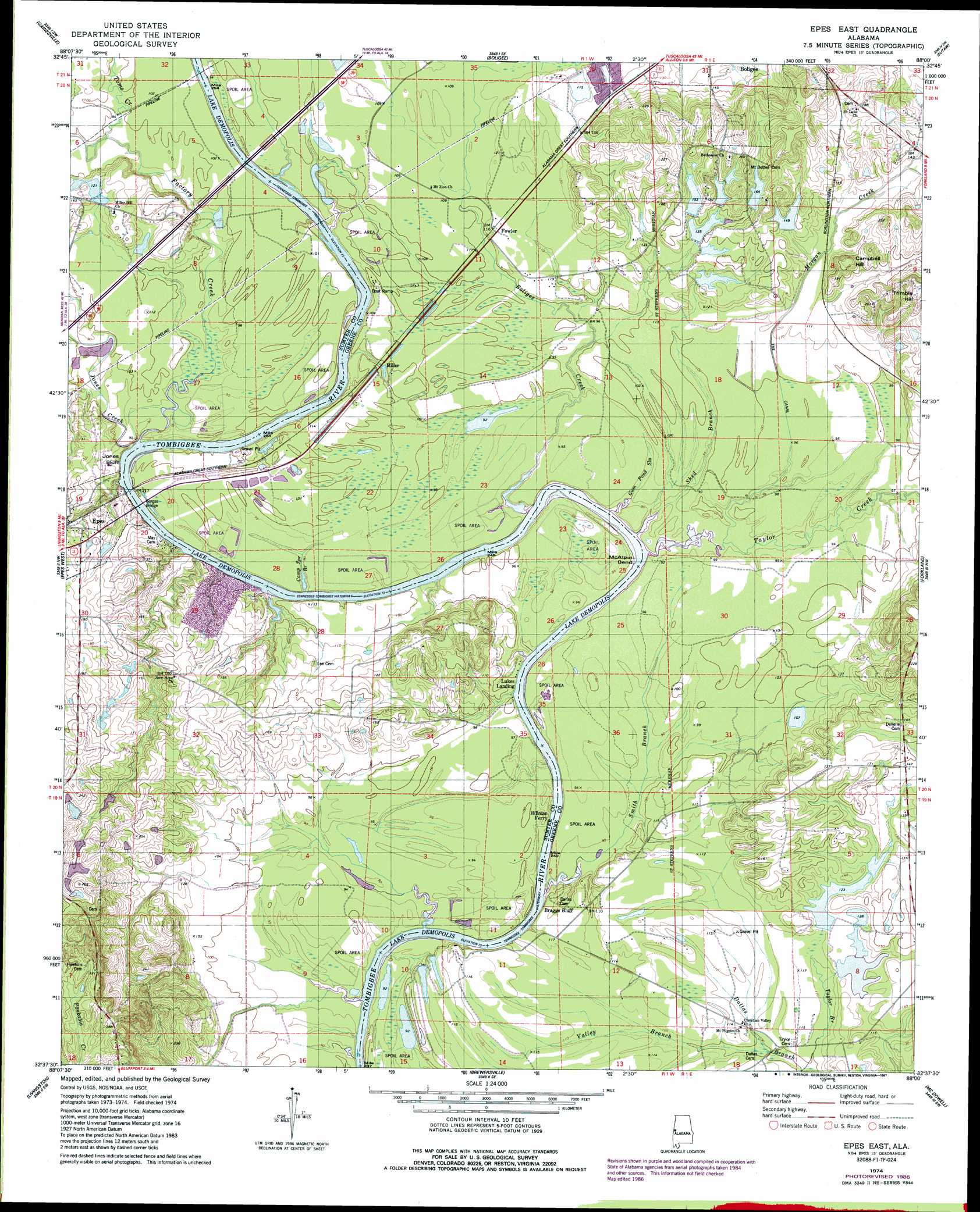
Epes East Topo Map Alabama
To zoom in, hover over the map of Epes East
USGS Topo Quad 32088f1 - 1:24,000 scale
| Topo Map Name: | Epes East |
| USGS Topo Quad ID: | 32088f1 |
| Print Size: | ca. 21 1/4" wide x 27" high |
| Southeast Coordinates: | 32.625° N latitude / 88° W longitude |
| Map Center Coordinates: | 32.6875° N latitude / 88.0625° W longitude |
| U.S. State: | AL |
| Filename: | o32088f1.jpg |
| Download Map JPG Image: | Epes East topo map 1:24,000 scale |
| Map Type: | Topographic |
| Topo Series: | 7.5´ |
| Map Scale: | 1:24,000 |
| Source of Map Images: | United States Geological Survey (USGS) |
| Alternate Map Versions: |
Epes East AL 1974, updated 1978 Download PDF Buy paper map Epes East AL 1974, updated 1987 Download PDF Buy paper map Epes East AL 2011 Download PDF Buy paper map Epes East AL 2014 Download PDF Buy paper map |
1:24,000 Topo Quads surrounding Epes East
Panola |
Warsaw |
West Greene |
Union |
Knoxville |
Geiger |
Gainesville |
Boligee |
Eutaw |
Warrior Dam |
Emelle |
Epes West |
Epes East |
Forkland |
Mason Bend |
Boyd |
Livingston |
Brewersville |
Mcdowell |
Demopolis |
York |
Bellamy |
Coatopa |
Jefferson |
Old Spring Hill |
> Back to 32088e1 at 1:100,000 scale
> Back to 32088a1 at 1:250,000 scale
> Back to U.S. Topo Maps home
Epes East topo map: Gazetteer
Epes East: Bars
Belfast Bar elevation 22m 72′Boligee Bar elevation 22m 72′
Boligee Lower Bar elevation 22m 72′
Epes Bar elevation 22m 72′
Hayes Bar elevation 28m 91′
Jones Bluff Shoals elevation 22m 72′
Jones Creek Bar elevation 22m 72′
Millers Bar elevation 22m 72′
Phillips Bar elevation 22m 72′
Santos Bar elevation 22m 72′
Epes East: Bends
McAlpin Bend elevation 28m 91′Epes East: Bridges
Gorgas Bridge elevation 22m 72′Epes East: Canals
The Canal elevation 28m 91′Epes East: Cliffs
Braggs Bluff elevation 34m 111′Jones Bluff elevation 22m 72′
McAlpine Bluff elevation 28m 91′
Epes East: Crossings
Hayes Ferry (historical) elevation 31m 101′Hillman Ferry (historical) elevation 22m 72′
Martans Ferry (historical) elevation 23m 75′
McAlpines Ferry (historical) elevation 22m 72′
Epes East: Dams
C N Drennen Dam Number 1 elevation 41m 134′C N Drennen Dam Number 2 elevation 32m 104′
C N Drennen Dam Number 3 elevation 42m 137′
C N Drennen Dam Number 4 elevation 41m 134′
Don Drennen Dam Number 1 elevation 45m 147′
Don Drennen Dam Number 2 elevation 46m 150′
Nab Drennen Dam Number 2 elevation 35m 114′
Nab Drennen Dams elevation 33m 108′
T H Spree Eight Feet Dam elevation 36m 118′
T H Spree Fourteen Feet Dam elevation 34m 111′
W D Johnston Dam elevation 38m 124′
W D Johnston Dams elevation 40m 131′
Epes East: Islands
Hales Island (historical) elevation 22m 72′Hillmans Island (historical) elevation 22m 72′
Houstons Island (historical) elevation 22m 72′
Epes East: Populated Places
Fowler elevation 35m 114′Miller elevation 31m 101′
Epes East: Post Offices
Epes Post Office elevation 46m 150′Epes East: Reservoirs
C N Drennen Lake Number 1 elevation 41m 134′C N Drennen Lake Number 2 elevation 32m 104′
Drennen Lake Number 1 elevation 45m 147′
Drennen Lake Number 2 elevation 46m 150′
Drennen Lake Number 3 elevation 42m 137′
Drennen Lake Number 4 elevation 41m 134′
Nab Drennen Lake Number 1 elevation 33m 108′
Nab Drennen Lake Number 2 elevation 35m 114′
Sprees Ten Acre Lake elevation 34m 111′
Sprees Twenty Acre Lake elevation 36m 118′
W D Johnston Lake Number 1 elevation 38m 124′
W D Johnston Lake Number 2 elevation 40m 131′
Epes East: Streams
Boligee Creek elevation 22m 72′Camp Spring Branch elevation 22m 72′
Factory Creek elevation 23m 75′
Gum Pond Slough elevation 23m 75′
Jones Creek elevation 23m 75′
Martins Creek elevation 25m 82′
Morgan Creek elevation 23m 75′
Shed Branch elevation 23m 75′
Smith Branch elevation 25m 82′
Taylor Creek elevation 23m 75′
Toms Creek elevation 28m 91′
Valley Branch elevation 30m 98′
Epes East: Summits
Campbell Hill elevation 66m 216′Trimble Hill elevation 77m 252′
Epes East: Valleys
Bryant Gulley elevation 28m 91′Epes East digital topo map on disk
Buy this Epes East topo map showing relief, roads, GPS coordinates and other geographical features, as a high-resolution digital map file on DVD:
Gulf Coast (LA, MS, AL, FL) & Southwestern Georgia
Buy digital topo maps: Gulf Coast (LA, MS, AL, FL) & Southwestern Georgia
 & Southwestern Georgia map DVD")