House Topo Map Mississippi
To zoom in, hover over the map of House
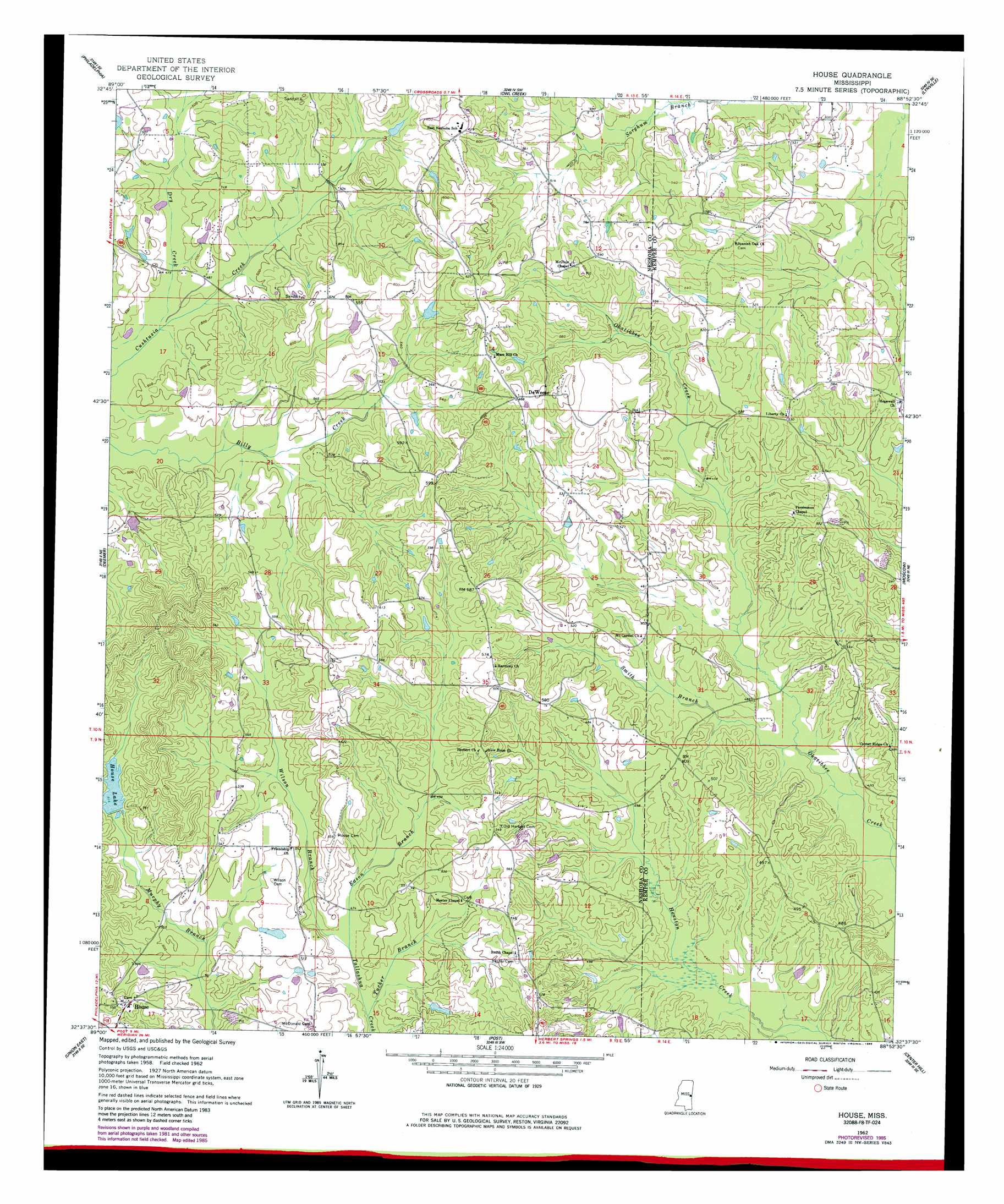
USGS Topo Quad 32088f8 - 1:24,000 scale
| Topo Map Name: | House |
| USGS Topo Quad ID: | 32088f8 |
| Print Size: | ca. 21 1/4" wide x 27" high |
| Southeast Coordinates: | 32.625° N latitude / 88.875° W longitude |
| Map Center Coordinates: | 32.6875° N latitude / 88.9375° W longitude |
| U.S. State: | MS |
| Filename: | o32088f8.jpg |
| Download Map JPG Image: | House topo map 1:24,000 scale |
| Map Type: | Topographic |
| Topo Series: | 7.5´ |
| Map Scale: | 1:24,000 |
| Source of Map Images: | United States Geological Survey (USGS) |
| Alternate Map Versions: |
House MS 1962, updated 1963 Download PDF Buy paper map House MS 1962, updated 1982 Download PDF Buy paper map House MS 1962, updated 1985 Download PDF Buy paper map House MS 2012 Download PDF Buy paper map House MS 2015 Download PDF Buy paper map |
1:24,000 Topo Quads surrounding House
Plattsburg |
Noxapater |
Vernon |
Preston |
Gholson |
Pearl River |
Philadelphia |
Owl Creek |
Lynville |
De Kalb |
Mcdonald |
Deemer |
House |
Moscow |
Lauderdale Nw |
Union West |
Union East |
Post |
Center Hill |
Daleville |
Decatur Nw |
Decatur |
Duffee |
Collinsville |
Meridian North |
> Back to 32088e1 at 1:100,000 scale
> Back to 32088a1 at 1:250,000 scale
> Back to U.S. Topo Maps home
House topo map: Gazetteer
House: Dams
Hester Lake Dam elevation 157m 515′Union Sportsman Club Lake Dam elevation 157m 515′
House: Populated Places
DeWeese elevation 176m 577′Herbert (historical) elevation 153m 501′
House elevation 174m 570′
Spinks (historical) elevation 166m 544′
House: Reservoirs
House Lake elevation 152m 498′House: Streams
Dry Creek elevation 142m 465′Eason Branch elevation 140m 459′
Smith Branch elevation 128m 419′
Tucker Branch elevation 139m 456′
Wilson Branch elevation 140m 459′
House digital topo map on disk
Buy this House topo map showing relief, roads, GPS coordinates and other geographical features, as a high-resolution digital map file on DVD:
Gulf Coast (LA, MS, AL, FL) & Southwestern Georgia
Buy digital topo maps: Gulf Coast (LA, MS, AL, FL) & Southwestern Georgia
 & Southwestern Georgia map DVD")