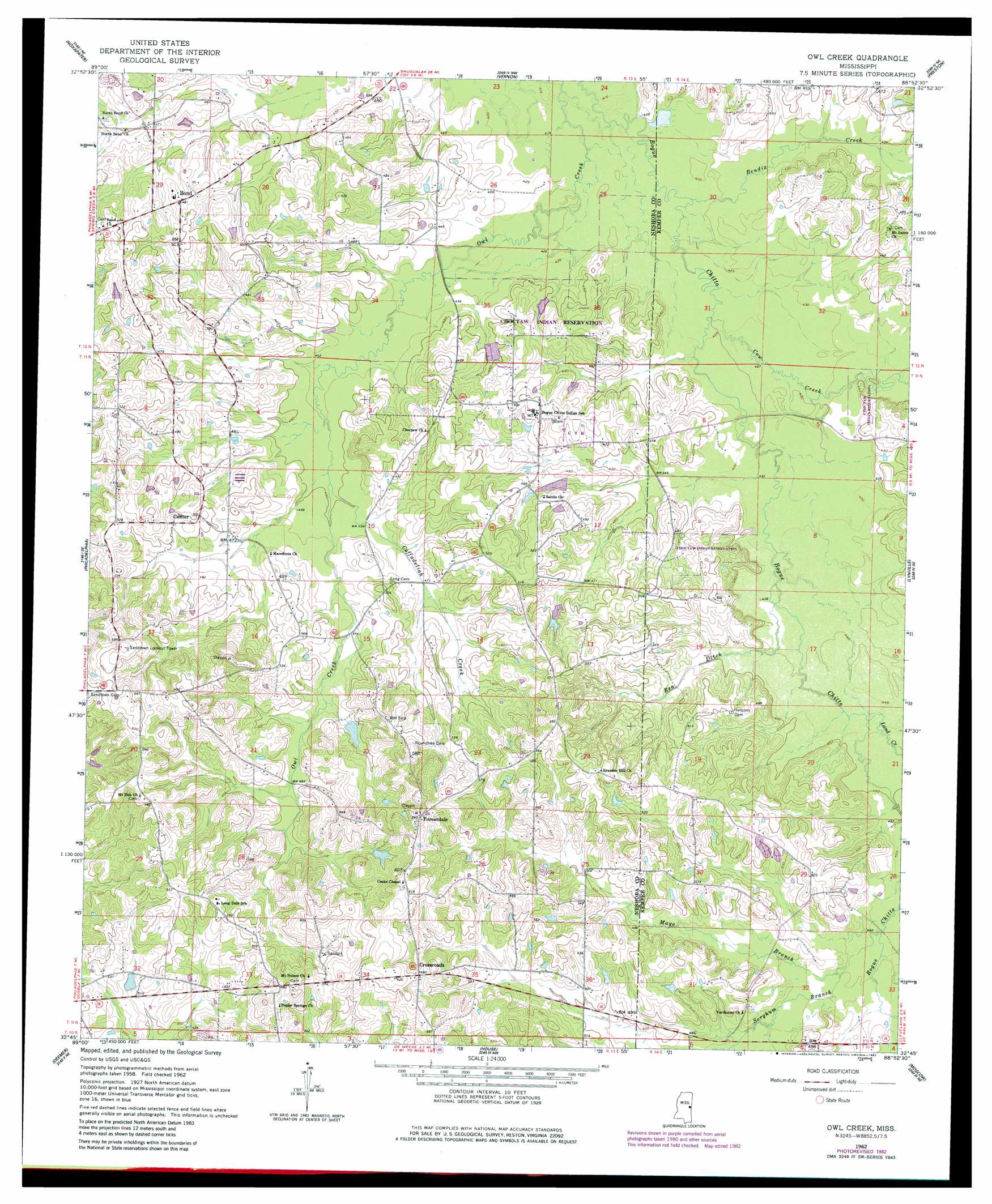
Owl Creek Topo Map Mississippi
To zoom in, hover over the map of Owl Creek
USGS Topo Quad 32088g8 - 1:24,000 scale
| Topo Map Name: | Owl Creek |
| USGS Topo Quad ID: | 32088g8 |
| Print Size: | ca. 21 1/4" wide x 27" high |
| Southeast Coordinates: | 32.75° N latitude / 88.875° W longitude |
| Map Center Coordinates: | 32.8125° N latitude / 88.9375° W longitude |
| U.S. State: | MS |
| Filename: | o32088g8.jpg |
| Download Map JPG Image: | Owl Creek topo map 1:24,000 scale |
| Map Type: | Topographic |
| Topo Series: | 7.5´ |
| Map Scale: | 1:24,000 |
| Source of Map Images: | United States Geological Survey (USGS) |
| Alternate Map Versions: |
Owl Creek MS 1962, updated 1963 Download PDF Buy paper map Owl Creek MS 1962, updated 1982 Download PDF Buy paper map Owl Creek MS 2012 Download PDF Buy paper map Owl Creek MS 2015 Download PDF Buy paper map |
1:24,000 Topo Quads surrounding Owl Creek
Louisville Sw |
Louisville South |
Boon |
Fearns Springs |
Mashulaville |
Plattsburg |
Noxapater |
Vernon |
Preston |
Gholson |
Pearl River |
Philadelphia |
Owl Creek |
Lynville |
De Kalb |
Mcdonald |
Deemer |
House |
Moscow |
Lauderdale Nw |
Union West |
Union East |
Post |
Center Hill |
Daleville |
> Back to 32088e1 at 1:100,000 scale
> Back to 32088a1 at 1:250,000 scale
> Back to U.S. Topo Maps home
Owl Creek topo map: Gazetteer
Owl Creek: Dams
Guy Gray Lake Dam elevation 144m 472′Indian Reservation Lake Dam elevation 143m 469′
Pat McDonald Lake Dam elevation 161m 528′
Owl Creek: Populated Places
Bogue Chitto elevation 149m 488′Bond elevation 146m 479′
Crossroads elevation 179m 587′
Forestdale elevation 180m 590′
North Bend elevation 142m 465′
Red Bud (historical) elevation 152m 498′
Owl Creek: Streams
Bendix Creek elevation 127m 416′Coffadeliah Creek elevation 136m 446′
Cow Creek elevation 129m 423′
Land Creek elevation 135m 442′
Mayo Branch elevation 139m 456′
Rea Ditch elevation 133m 436′
Sorghum Branch elevation 140m 459′
Owl Creek digital topo map on disk
Buy this Owl Creek topo map showing relief, roads, GPS coordinates and other geographical features, as a high-resolution digital map file on DVD:
Gulf Coast (LA, MS, AL, FL) & Southwestern Georgia
Buy digital topo maps: Gulf Coast (LA, MS, AL, FL) & Southwestern Georgia
 & Southwestern Georgia map DVD")